File contains a copy of “The Defenitive Treaty of Peace and Friendship Between His Britannick Majesty, and the United States of America”, signed at Paris on Sept. 3rd 1783; including in the peace agreement is the Canada (Southern) Boundary.
File contains a 1783 letter from surveyor, W. Samuel Holland, to General Hallimand in Quebec regarding the establishments of settlements along the St. Lawrence and the Mohawks.
File contains a typescript excerpt of The Rambling River, written and compiled by Mary G. Plumption, concerning the early settlement of Thurlow Township from 1784, together with brief biographical information on Lord Thurlow, and Baron Rawdon, Earl of Moira. Also present are four printed lists of Thurlow Township land holders by name and date of patent from 1798-1818.
A survey plan map of the Township of Fredericksburg, 1784. Contains names of local property owners and bodies of water. Composed by James Peachy, Lewis Kotte, Henry Holland and Samuel Jaffe. Scale: 40 chains in an inch. Dimensions: 53cm x 39cm.
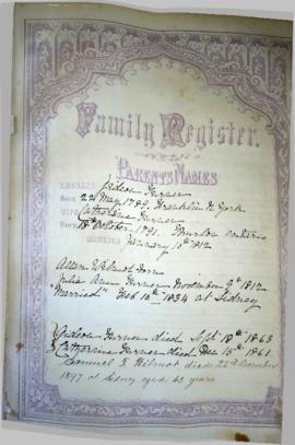
The file contains a typed copy of Samuel Sherwood's account book. Included is a brief biography as well as a genealogy of Samuel, his wife and children, dated from 1754-1924.
Map showing the Bay of Quinte to Presqu'ile to the eastern tip of Grande Isle (Wolfe Island) used as a teacher's guide to the area in 1785. The 20th century names are in capital letters as per the Legend.
Papers collected by members of the Dafoe, Lloyd and Reid families of Thurlow and Sidney Townships, Hastings County. The collection includes:
1899 [solicitor's?] account book used as scrapbook for newspaper clippings about hymns and Methodism (some entries from the account book are still visible), 1940s. Includes an essay from 1921 on the benefits of music for improving society.
Newspaper clippings, 1916-1964
Various receipts and flyers, including advertisements for a Copperstyle washing machine and wringer, and a bagless vacuum cleaner, 1929-1954
Orders of service from various United Churches, including one to be used at the end of hostilities in the Second World War, 1911-1950 and International Plowing Match promotional materials from 1961
Photograph of Keitha Lloyd as a child, c.1910; postcards of Potters Creek camp ground, 1930s; text of a talk by Norma Lloyd Dafoe on the first automobile in Belleville, c.1950
1940s scrapbook on anniversaries and churches made using an edition of Star Weekly of 27 May 1944
Digital copies of notes on the family history of the Wilmot, Merritt, Chisholm and Wartman families, 1785-1940
A copy of an original map by Surveyor General John Collins showing land from Presqu'ile to Kingston in 1785. Scale: 4 miles : 1 inch. Photocopied by the Archives of Canada 10 Jan 1990.
This collection comprises some 4,400 vertical files of materials gathered by the Hastings County Historical Society. They cover a wide range of subjects and were received from a variety of different sources, not always recorded.
The collection includes original materials, newspaper clippings, secondary histories and copies.
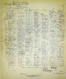
A recopy of the 1787 map of Sidney Township. The original map entitled "Plan of the Township of Sidney in the District of Mecklinburg. Surveyed in 1787 by Lewis Kotts, with the names of the proprietor inserted in the Lots." The recopy was completed by Mrs. Dorothy Ashton in 1981, for the Corby Public Library and Hastings County Historical Society. Scale 40 chains to an inch.
File contains photocopied manuscript lists of persons nominated for township and parish officers in Sidney Township, 1790-1819. Also contains a newspaper article regarding the establishment of the Sidney Township Council and highlights of its proceedings to the 1930s. Also present is photocopied typescript outline of the history of Sidney Township and Trenton from ca. 1787-1819.
File contains a photocopy from the original of land grants including name of grantee, date, acreage,concession and lot in Thurlow Township from 1787-ca.1890.
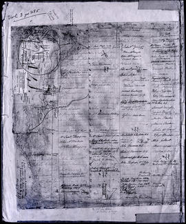
A map of the Township of Thurlow, in 1787. Contains names of local property owners within their respective lots. Surveyed by Deputy Provincial Surveyor Lewis Kotte. Scale: 40 chains : 1 inch.
This description is for part of a collection of some 4,400 vertical files of materials gathered by the Hastings County Historical Society. They cover a wide range of subjects and were received from a variety of different sources, not always recorded.
The collection includes original materials, newspaper clippings, secondary histories and copies.
A map of Sidney Township, specifically the District of Mecklenburg in 1787. Contains information on the plans for the 1st, 2nd, and 3rd concessions, as well as property owners. Created by Lewis Kotte, Deputy Provincial Surveyor. Scale: 40 chains to an inch.
A land grant map of the Township of Thurlow, in 1787. Contains names of local property owners within their respective lots and concessions 1-4. Footnotes around the waterfront were added c.1960. Dimensions: 22cm x 28cm.