
- CA ON00156 M
- Collection
- 1792-2018
Maps collected by the Hastings County Historical Society and added to by the Community Archives of Belleville and Hastings County. The maps cover locations in Hastings County and extend to all of Canada.
Sans titre
897 résultats avec objets numériques Afficher les résultats avec des objets numériques
Maps collected by the Hastings County Historical Society and added to by the Community Archives of Belleville and Hastings County. The maps cover locations in Hastings County and extend to all of Canada.
Sans titre
Fait partie de Map collection
Sans titre
Fait partie de Map collection
Road Map of Ontario, 2008-2009
Fait partie de Map collection
Sans titre
Fait partie de Map collection
Sans titre
Maps of the National Topographic System - Index 1
Fait partie de Map collection
Canada Maps of the National Topographic System Index #1 (Montreal and East). Dated October 31, 1969. Scale: 1:50,000.
Sans titre
Maps of the National Topographic System - Index 21
Fait partie de Map collection
Canada Maps of the National Topographic System Index #21 (All of Canada). Dated 1970. Scale: 1:500,000.
Sans titre
Maps of the National Topographic System - Index 2
Fait partie de Map collection
Canada Maps of the National Topographic System Index #2 (Ontario). Dated May 31, 1970. Scale: 1:50,000.
Sans titre
Belleville Transit Rider Guide and Schedule 2015
Fait partie de Map collection
A map featuring the transit routes, street routes and rider fares for the Belleville Bus Transit system.
Sans titre
Belleville Transit Rider Guide and Schedule 1979
Fait partie de Map collection
A map featuring the transit routes, street routes and rider fares for the Belleville Bus Transit system.
Sans titre
Belleville Transit Rider Guide and Schedule 2018
Fait partie de Map collection
A map featuring the transit routes, street routes and rider fares for the Belleville Bus Transit system.
Sans titre
Belleville Transit Rider Guide and Schedule 2017
Fait partie de Map collection
A map featuring the transit routes, street routes and rider fares for the Belleville Bus Transit system.
Sans titre
Belleville Transit Rider Guide and Schedule 2016
Fait partie de Map collection
A map featuring the transit routes, street routes and rider fares for the Belleville Bus Transit system.
Sans titre
Belleville Transit Rider Guide and Schedule 2010
Fait partie de Map collection
A map featuring the transit routes, street routes and rider fares for the Belleville Bus Transit system.
Sans titre

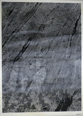
Fait partie de Map collection
A reproduction of an air survey photograph produced by the Ontario Ministry of Natural Resources. Map # 444773E of Rawdon Township in Hastings County, Ontario. Circa 1950.
The photograph shows Rawdon Township from the eastern border to Hwy 14, Harold and Springbrook Villages, western Huntingdon Township, southern Marmora and Madoc Townships, Banker Lake.
Donated by Walter I. Watson, P.L.S.
Sans titre

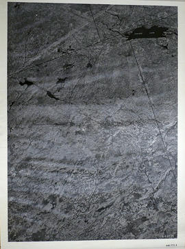
Fait partie de Map collection
A reproduction of an air survey photograph produced by the Ontario Ministry of Natural Resources. Map # 444773W of Rawdon Township in Hastings County, Ontario. Circa 1950.
The photograph shows Rawdon Township, Concession 8 to 14, west of Hwy 14, small sections of Marmora Township including Marmora Village and Crow Lake and a small part of Seymour Township in Northumberland County
Donated by Walter I. Watson, P.L.S.
Sans titre
Sheffield Township Map # 445771E
Fait partie de Map collection
A reproduction of an air survey photograph produced by the Ontario Ministry of Natural Resources. Map #445771E of Sheffield Township in Lennox and Addington County, Ontario. Circa 1950.
The photograph shows Sheffield Township, Concession 3 to 9, Beaver Lake and north to Kaladar Township, Concession VIII to XI, Lingham Lakes in Grimthorpe Township in Hastings County.
Donated by Walter I. Watson, P.L.S.
Sans titre
Elzevir Township Map # 446772E
Fait partie de Map collection
A reproduction of an air survey photograph produced by the Ontario Ministry of Natural Resources. Map #446772E of Elzevir Township in Hastings County, Ontario. Circa 1950.
The photograph shows the North East part of Elzevir Township, Elzevir Creek and the Skootamata River.
Donated by Walter I. Watson, P.L.S.
Sans titre
Election Canada Advance Polling Stations in Belleville
Fait partie de Map collection
A reproduced map detailing advance electoral polling stations within the City of Belleville. The map includes Bayview Mall, Fire Dept Training Office and St. Mark's United Church as stations, wards and boundaries.
Sans titre
Fait partie de Map collection
An aerial photograph of Napanee (Map # 49C4709/70). Map includes: Napanee River and Village in the Townships of South & North Fredericksburg. A small part of Ernestown & Camden Townships. Concession 1 to 5 of Richmond Township, Deseronto and Hay Bay Circa 1970. Scale: 1:2,000.
Map includes Trans-Northern Pipeline and Trans Canada Pipeline and the Hydro Lines. Donated by Walter I. Watson, P. L. S.