Mecklenburg, District of Proclamation by George III, July 24, 1788 - Establishing same
- CA ON00156 TR/3526
- File
- 1788
Proclamation made by George III on the formation of the District of Mecklenburg.
16 results with digital objects Show results with digital objects
Mecklenburg, District of Proclamation by George III, July 24, 1788 - Establishing same
Proclamation made by George III on the formation of the District of Mecklenburg.
Map of Townships by waterfront and Mohawk Territory
Part of Map collection
Map showing townships by the waterfront of the Bay of Quinte and the Mohawk Territory. This area encompasses townships in both Prince Edward and Hastings Counties. Text on map says "District of Nassau." Dated 1790. Map copied from the Archives of Ontario.

Map of District of Prince Edward County
Part of Map collection
Map showing townships in the District of Prince Edward County: South Murray, Sidney, Thurlow, Ameliasburgh, Sophiasburgh. See boundary lines on map. Surveyed by Publius Virgillius Elmore, D.L.S. Dated 1835. Map copied from the Archives of Ontario.
Elmore, Publius Virgillius, D.P.S.

Map of Districts of Prince Edward and Midland
Part of Map collection
Map showing counties, townships, concessions and lots in the Districts of Prince Edward and Midland. Surveyed by Publius Virgillius Elmore, D.L.S. Published by Hallowell U.C. Dated 1836. Scale 160 chains : 1". Map copied from the Archives of Ontario.
Elmore, Publius Virgillius, D.P.S.
Huyck Islands claimed by Alnwick Indians
Part of Map collection
An original, waxed linen map entitled "Islands claimed by Alnwick Indians, Pursuant to Instructions bearing date Crown Lands, Dept. Quebec 2nd October 1861." The area in mention concerns the Huyck Bay Islands, Lake Ontario, and Pleasant Bay. Surveyed by Duncan McDonell Greenfield and John McNaughton, P. L. S. in May, June, July and August, 1862. Scale: 8 chains to an inch.
McNaughton, John, P.L.S. & D.P.S.

West Lake Islands claimed by Alnwick Indians
Part of Map collection
An original, waxed linen map entitled "Islands claimed by Alnwick Indians, Pursuant to Instructions bearing date Crown Lands, Dept. Quebec 2nd October 1861." The area in mention concerns the West Lake Islands, in Prince Edward County. Surveyed by Duncan McDonell Greenfield and John McNaughton, P. L. S. in May and June 1862. Scale: 8 chains to an inch.
McNaughton, John, P.L.S. & D.P.S.

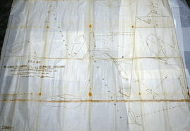
Weller's and Hay Bay Islands claimed by Alnwick Indians
Part of Map collection
An original, waxed linen map entitled "Plans of Islands claimed by the band of Alnwick Indians. Pursuant to Instructions bearing date “Crown Lands Department” Quebec 2nd October 1861." The area in mention concerns Weller's Bay and Hay Bay, in Prince Edward County. Surveyed by John McNaughton, P. L. S. in April and May 1862. Scale: 8 chains to an inch.
McNaughton, John, P.L.S. & D.P.S.
Wilkins, Col. Charles, 1782-1867
A history on Col. Charles Wilkins and notes made by Mr. Gerald Boyce. 13 pages.

A family history on the Wilkins' family. 2 pages.

Map of the Counties of Hastings and Prince Edward
Part of Map collection
A "Map of the Counties of Hastings and Prince Edward." In 1898, the lots, concessions, churches, schools and mines are shown of the townships in Hastings and Prince Edward. Scale: 1.5 miles to an inch. Published by the Canadian Map Publishing Company in Hamilton, Ontario, for the Belleville Sun. Revised by Henry Carre, C.E. Inset is the map of North Hastings, scale 400 chains to an inch.
Carre, Henry, O.L.S.
Young, Lieut. Col. Reuben Young - Obituary 1899
File contains the obituary (7-February-1899) for Lt. Col. Reuben Young. Born 19-July-1805 in Carrying Place, oldest son of Lieut. Col. James Young, M.P. Lt. Col. Reuben Young married Nancy Briant in 1829, she predeceased him 10 years.

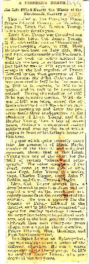
Sprague Family, Prince Edward County History
This file contains a newspaper clipping titled "The Sprague Family: How They Migrated From New York to Prince Edward".

Map Hastings, Prince Edward, Northumberland and Peterborough Counties
Part of Map collection
A map of Hastings, Prince Edward, Northumberland and Peterborough counties in 1916 from the Department of Interior Canada. Published by J.E. Chalifour, Chief Geographer. Scale: 3" to 95 miles. Dimensions 63.5cm x 96.5cm.
The legend includes additional information about counties, towns, villages, boundaries, railways, canals, lots, concessions, portages, rapids and First Nations Territories.
Canada. Department of the Interior

Topographical Map of Ontario - Belleville Sheet
Part of Map collection
A map of Hastings, Prince Edward, Northumberland and Peterborough counties in 1929 from the Department of Interior Canada. By J.E. Chalifour, Chief Geographer. Scale: 1" to 3.95 miles.
The legend includes additional information about counties, towns, villages, boundaries, railways, canals, lots, concessions, portages, rapids and First Nations Territories.
Canada. Department of the Interior

Topographical map of Duck Island
Part of Map collection
A topographical map of Duck Island- Canada sheet #30 N/15. Published by the Army Survey Establishment, Department of National Defence in 1932. Scale one inch to one mile - 1/63, 360.
Donated by Gerry Boyce.
Canada. Department of National Defence

Topographic Map of Ontario - Belleville Sheet
Part of Map collection
A map from the Eastern Canada series entitled "Topographic Map of Ontario - Belleville Sheet 31 C/3." The map includes Hastings County to Hillier in Prince Edward County. Published in 1938 by the Department of National Defence. Scale 1 inch to 1 mile.
Donated by the Belleville Public Library in 2014.
Canada. Department of National Defence
Topographical maps of Wellington
Part of Map collection
A topographical map of Wellington - Canada sheet #30 N/14, both east and west half sheets. Published by the Army Survey Establishment, Department of National Defence in 1951. Scale 1:50,000.
Canada. Department of National Defence
File contains the genealogy for George & Mary Lawrence Young, descended from Oliver Cromwell, settled Hastings County and donated land for present day Belleville Cemetery. The file also contains newspaper clippings from 1955 about the celebrations for Beniah Young's 101st birthday (January 12, 1955) and his obituary (November 2, 1955). Mr. Ben Young was born in Roblin's Mills, Prince Edward County and died in Trenton, Ontario. He is buried in Carrying Place Cemetery. Mr. Beniah Young was a decedent of George & Mary Lawrence Young.

Road Map of Prince Edward County 1955
Part of Map collection
A road map of Prince Edward County in 1955. Portions of adjoining counties are also pictured. County boundaries are yellow, while roads are blue and red. Published by the Ontario Department of Highways. Scale: 1 inch = 4 miles.
Ontario. Department of Highways
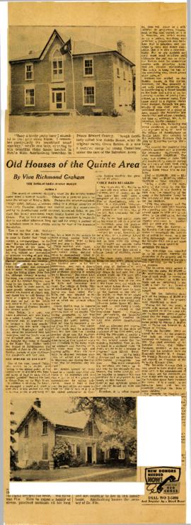
Newspaper article on the Roblin grey-stone house in Ameliasburgh. Includes photographs.