
- CA ON00156 CH/13/1/6
- Item
- 1884
Part of County of Hastings records
Digital copy of 1884 Union Publishing Company's directory of the Counties of Frontenac, Hastings, Lennox, Addington, Prince Edward
41 results with digital objects Show results with digital objects
Part of County of Hastings records
Digital copy of 1884 Union Publishing Company's directory of the Counties of Frontenac, Hastings, Lennox, Addington, Prince Edward
Part of County of Hastings records
Digital copy of 1886 Directory of the Counties of Frontenac, Hastings, Lennox, Addington, Prince Edward

Part of County of Hastings records
Digital copy of 1893 Union Publishing Company's directory of the Counties of Durham, Hastings, Lennox, Addington, Northumberland, Prince Edward

Part of County of Hastings records
Digital copy of 1899 Union Publishing Company's directory of the Counties of Frontenac, Hastings, Lennox, Addington, Prince Edward
Entry for Historical Fiction Writing Contest by W. D. Hawthorne. Three excerpts from "Gunshot and Gleanings of the Historic Carrying Place, Bay of Quinte" and "Joe Alcorn's Boy". 10 Pages.
Adult Writing Contest - Wannamaker, John "Reminiscences of Cashel Township"
Entry for Historical Fiction Writing Contest by John Wannamaker. 39 Pages.
Aerial Photograph of Prince Edward County
Part of Map collection
An aerial photograph of Prince Edward County.
Northway Photomap Inc.
Aerial Photograph of Sophiasburgh Township
Part of Map collection
An aerial photograph of Sophiasburgh Township, Map # 1.71-4402- 2-144 (enlarged section). The total area covered includes, Consecon Creek and Marsh, Hwy 62, County Road 2 and west Concession 7 in centre of map. A “Little Swamp”, Provincial Government Aerial Photo. Scale 1:10,000. Dated 1971.
Aerial Photograph of Sophiasburgh Township
Part of Map collection
An aerial photograph of Sophiasburgh Township, Map # 1.71-4402- 2-144, (small section). The total area covered includes, Hwy 62 along the east side, Smith Road on west side, and in the centre Concession 7. A Provincial Government Aerial Photo. Dated 1971.
Aerial Photograph of Sophiasburgh Township
Part of Map collection
An aerial photograph of Sophiasburgh Township, Map # 1.71-4402- 2-144. The total area covered includes, Consecon Creek and Marsh, Hwy 62, County Road 2 and west Concession 7 in centre of map. A “Little Swamp”, Provincial Government Aerial Photo. Scale 1:10,000. Dated 1971.
Aerial Photograph of west Prince Edward County
Part of Map collection
An aerial photograph of Prince Edward County focusing on the area north from Pleasant Bay to south Huyck's Bay.
History of Victoria Sunday School, Rednersville Church
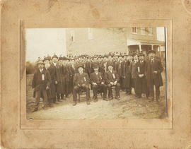
Ancient Order of United Workmen, Lodge 262 photograph
Photograph of members of the Ancient Order of United Workmen, Lodge 262 (Ameliasburgh) and two newspaper clippings from 1983 relating to the society.
Individuals identified are:
Seated: 1. ? Carnrite [Carnrike?]
James E. Glenn
Albert Lont
Dorland Fox
Dr. File M.D.
Moran Lont
Lewis Lont
Fred File
Gil Choat?
Byron Frederick
Ferris Wood
Francis Wood
John Tice
James A. Van Cott
William Bisdee
Charles Wood
Jessie Sprong
Albert Crosby
Will Reddick
Edgar Redner?
Fred Lauder?
Architectural Conservancy of Ontario, Quinte Region Branch records
Contains mostly the Quinte Branch newsletter but also correspondence, minutes, reports and a number of walking tours of Belleville and Picton. Some of the minutes from meetings are also included as are some newspaper clippings associated with historic buildings of the region.
Architectural Conservancy of Ontario, Quinte Branch
The file contains a copy of the publication "Journal of the Society for the study of Architecture in Canada" Vol. 30, no. 2, 2005. On pages 25-38 there is an article (with pictures) titled "Joseph Connolly in the Roman Catholic Archdiocese of Kingston, Ontario. It discusses churches in Belleville, Kingston, Kemptville, Prescott, Tweed, Grafton, Gananoque and Picton.
Argyll Light Infantry : first organization and inspection
File contains a printed account of the organization of the 15th Battalion Argyll Light Infantry and its initial inspection and review at Picton on 29 July 1863.
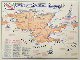
Map showing the location, names and dates of shipwrecks around the shoreline of Prince Edward County.
Ralley, Allan A.

Article on building of Skyway Bridge
Newspaper clipping (possibly from the Intelligencer newspaper of Belleville) with a photograph of the construction of the piers of the new Skyway Bridge at Green Point in Prince Edward County, Ontario.
The file contains three newspaper articles (2 from The Intelligencer; 1 from The Community Press, Quinte Edition), all from November 2004 and about Donnah Cameron celebrating 90 yeas as an artist.
Account book of John Bailey, a farmer in Madoc. Contains lists of expenses, expenditures and assets of farm operation.