An original plan entitled "Plan of Indian Lands in Tyendinaga Leased 999 Years." Surveyed by William R. Aylsworth, O.L.S. of Belleville. Also written on the plan is "Wallbridge's Plan of Part of Shannonville. Was filed in the Registry Office of Hastings June 21, 1872."
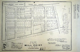
A certified reproduction of the Plan of part of Mill Point in parts of Lots # 38-39 in Concession A of Tyendinaga. Proprietors: H. B. Rathbun & E. W. Rathbun. Surveyed by William R. Aylsworth, P.L.S. and signed March 29, 1871.
This copy was made in 1972 of plan #143, as registered in the Hastings Land Registry Office.
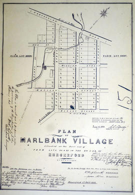
A certified reproduction of the "Plan of Marlbank Village situated on the rear end of farm Lots # 34 & 35 in 2nd Concession of Hungerford. Laid out by John Allen executor of the late James Allen." Surveyed by William R. Aylsworth, O.L.S., and signed February 1, 1865.
This copy was made in 1972 of plan #151, as registered in the Hastings Land Registry Office.
A certified reproduction of the "Plan of Lots Laid out on Block F of Stirling - prepared for F. B. Parker; J. Clare Halliwell.” Surveyed by William R. Aylsworth O. L. S. and dated May 16, 1901.
This copy was made in 1972 of plan #326, as registered in the Hastings Land Registry Office.
A certified reproduction of the "Subdivision of Block 60, Tweed, for proprietor James Quinn, witnessed by Stafford Quinn, clerk.” Surveyed by William R. Aylsworth, P.L.S., and signed August 17, 1900.
This copy was made in 1972 of plan #305, as registered in the Hastings Land Registry Office.
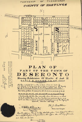
A certified reproduction of the "Plan of part of Deseronto, showing subdivision of Blocks J and H." Plan complied from W. R. Aylsworth P.L.S. in 1888 and resubdivided by M. J. Butler O.L.S. in November 14, 1898.
This copy was made in 1972 of plan #301, as registered in the Hastings Land Registry Office.
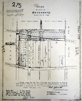
A certified reproduction of the "Plan of Part of Deseronto, Block J and Block H in part of Lot # 38 and Lot # 39 in Concession 2 and 3. Tyendinaga, for the Rathburn Company the proprietors.” Surveyed by William R. Aylsworth, P.L.S. and dated June 1, 1888.
This copy was made in 1972 of plan #275, as registered in the Hastings Land Registry Office.
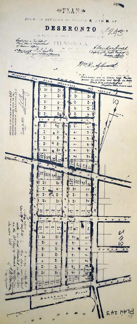
A certified reproduction of the "Plan showing of Blocks K and M of Deseronto, on west plot of Lot 3, Concession A, Township of Tyendinaga.” Blocks K and M are from Main Street north to the original Concession Road Allowance, west to Brant Street, and east to Mill Street. Plan signed by William R. Aylsworth, P.L.S. and dated March 26, 1885.
This copy was made in 1972 of plan #243, as registered in the Hastings Land Registry Office.
A certified reproduction of the "Plan of Incorporated Village of Marmora." The plan includes the Road Allowance between Concession 3 & 4 (west), side line between Lots # 8 & 9 (north), road allowance between Concession 4 & 5 plus Loucks Estate on part of Concession 5, Lot # 8 (east), and the Road Allowance between Lots # 5 & 6 (south). Surveyed by William R. Aylsworth, P.L.S., and signed September 31, 1901.
This copy was made in 1972 of plan #307, as registered in the Hastings Land Registry Office.
1972 Copy of Plan 162 registered in the Hasting County Land Registry Office, drawn up in 1873. The plan shows the lots in the village of Mill Point (incorporated in 1871, later named Deseronto), Ontario.
Map showing Grand Trunk railway extending from Belleville to Point Ann in Hastings County. Also shows different lots, with named proprietors and number of acres. Dated June 10, 1904. Scale: 1" : 400ft. Surveyed by R. Aylsworth, Ontario Land Surveyor.
Map showing CPR railway extending from Belleville to Point Ann in Hastings County. Dated June 15, 1903. Scale: 1" : 400ft. Surveyed by R. Aylsworth, Ontario Land Surveyor.