Showing 104 results

Archival description
Trenton With digital objects
Print preview Hierarchy View:

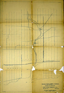
Trenton Electric & Water Co. Limited in Thurlow and Sidney Townships

  • CA ON00156 M/M430-2998 - 3001/M430-2999
  • Item
  • 31 Mar 1910
  • Part of Map collection

An original map produced for the Trenton Electric & Water Co. Limited, concerning proposed transmission lines within the Townships of Thurlow and Sidney. However, the map also features railways, roads, mills and land boundaries. Dated March 31, 1910. Scale: 1/4 mile = 1 inch. Map composed by Smith, Kerry and Chace Engineers located in Toronto, Winnipeg, Calgary and Vancouver.

The map includes the first 4 concessions, Lots 33-38 in Sidney Township and Lots 1-13 in Thurlow Township.

Donated by David Pershick.

Smith, Kerry and Chace Engineers

Photograph

A newspaper photograph of members of the Trenton Victoria Order of Nurses, Miss Mary Margaret Gillies, Mrs. Jean Onyette, Mrs. Ann Larry, and Mrs. Ann Smith, wearing VON uniforms from different eras.

Intelligencer

Map of Hastings with the Principal Villages and the City of Belleville

A map of Hastings County including the Town of Belleville and other principal villages:

Trenton, Madoc, Marmora, Tweed, Bridgewater, Stirling, Wicklow, Bangor, Herschel, Monteagle, Carl, Dungannon, Wollaston, Limerick, Cashel, Tudor, Grimsthorpe, Elzevir; Rawdon, Huntingdon, Hungerford, Sidney, Thurlow, Tyendinaga.

Scale: 3 miles =1 inch. Published by Evans & Bolger, P. L. Surveyors, P.L.S. in 1879-1880.

Evans and Bolger

Map of Hastings with townships

A map of Hastings County outlining the twelve townships:
Marmora and Lake, Madoc, Tudor, Grimsthorpe, Elzevir; Rawdon, Huntingdon, Hungerford, Sidney, Thurlow, Tyendinaga.
As well as, the lots and concessions. Circa 1916.Scale: 4 miles: 1 inch.

Donated by K.G.M. Ross.

Map of Murray Township showing several lots

A copy of an original map by Surveyor General David W. Smith showing several lots of land in Murray Township in the District of Newcastle. Specifically, the map shows Lots 1-5 near the 1st Concession and River Trent. Published by Henry Smith on July 24, 1799.

Donated by K.G.M. Ross in 1963.

Smith, David William

Diagram of Town plot called Trent Port

A copy of an original map by Deputy Provincial Surveyor F. P. Rubidge showing a diagram of a town plot at the mouth of the Trent River called the "Town of Trent Port." Specifically, the map shows Lot 2 near the 1st Concession bordering Murray Township in the County of Northumberland.
Published in Cobourg on September 25, 1852.
Donated by K.G.M. Ross.

Rubidge, Frederick Preston, D.P.S.

Map of Lot L on the Trent River

A photostat of a map by from an H. Belden & Company's atlas showing Lot L on the Trent River - 1878.
Donated by K.G.M. Ross in 1963.

H. Belden & Company

Burttdale Heights subdivision in Trenton

A certified reproduction of the "Burttdale Heights subdivision of Lots # 19 to 28 on East side of Reid Street. Reg'd plan no. 240, Trenton.” The area includes; Lots # 1 to 168, Block A-D, east of Reid Street and south of Hamilton Road, being Lot # 1 Concession 1, Township of Sidney. Surveyed by Ronald Benn, O. L. S. and signed October 14, 1964.

Donated by Walter I. Watson, P. L. S.

Benn, Ronald, O.L.S.

Plan of Mount Pelion Block in the Township of Murray

A certified reproduction of the "Plan of Mount Pelion Block, being a subdivision of the North Part of Block D, east half of Lot # 3, Concession 1 in Murray Township now Town of Trenton, for A.E.M. Falkiner.” Surveyed by Bolger and Drewry, P.L.S., and signed September 29, 1885.

This copy was made in 1972 of plan #249, as registered in the Hastings Land Registry Office.

Donated by Walter I. Watson, P. L. S.

Bolger and Drewry, P.L.S.

Subdivision of Block 1 in the Town of Trenton

A certified reproduction of the "Plan of subdivision of part of Block 1 in the Town of Trenton, being part of Lot # 3, Concession A, in Township of Murray. Property of J. H. Peck.” Surveyed by Thomas O. Bolger, P.L.S., and signed June 23, 1884.

This copy was made in 1972 of plan #246, as registered in the Hastings Land Registry Office.

Donated by Walter I. Watson, P. L. S.

Bolger, Thomas Oliver, P.L.S.

Plan of Park Lots 14, 17-18 in the Town of Trenton

A certified reproduction of the "Plan of subdivision of Park Lots # 14, 17 & 18, Lot # 1, Concession 1, Township Murray, now Town of Trenton, for Albert W. Hawley.” Surveyed by William S. Drewry, P.L.S., and dated November 1883.

This copy was made in 1972 of plan #236, as registered in the Hastings Land Registry Office.

Donated by Walter I. Watson, P. L. S.

Drewry, William Stewart, P.L.S.

Plan of Jubliee Block in the Town of Trenton

A certified reproduction of the "Plan of Jubilee Block, being subdivision of part of Block D situated on the east half of Lot # 3, Concession 1, Township of Murray, now in the Town of Trenton for Catherine MacLellan, owner.” Surveyed by John D. Evans, P.L.S., and signed June 4, 1888.

This copy was made in 1972 of plan #282, as registered in the Hastings Land Registry Office.

Donated by Walter I. Watson, P. L. S.

Evans, John Dunlop, P.L.S.

Subdivision of part of Block E in the Town of Trenton

A certified reproduction of the "Subdivision of Part of Block E on Evans & Bolger Plan of Trenton for Hugh Leonard O'Rourke and J. W. Crews.” Surveyed by Evans & Evans, Civil Engineers & O. L. S. and signed July 7, 1913.

This copy was made in 1972 of plan #445, as registered in the Hastings Land Registry Office.

Donated by Walter I. Watson, P. L. S.

Evans and Co., Engineers and Surveyors

Subdivision of Bayview Gardens in the Town of Trenton

A certified reproduction of the "Bayview Gardens, subdivision being part of Lot # 1, Concession 1, Sidney Township, Trenton.” Surveyed by Evans & Evans, Civil Engineers & O. L. S. and signed December 20, 1913.

This copy was made in 1972 of plan #453, as registered in the Hastings Land Registry Office.

Donated by Walter I. Watson, P. L. S.

Evans and Co., Engineers and Surveyors

Subdivision of Lot 22 in the Town of Trenton

A certified reproduction of the "Subdivision of Lot # 22 - east side of West Street in Trenton, for Alexander Miron.” Surveyed by Evans & Evans, Civil Engineers & O. L. S. and signed May 15, 1917.

This copy was made in 1972 of plan #474, as registered in the Hastings Land Registry Office.

Donated by Walter I. Watson, P. L. S.

Evans and Co., Engineers and Surveyors

Plan of part of the Hawley Estate in the town of Trenton

A certified reproduction of the Plan of part of “Hawley Estate” in the town of Trenton, along side of the River Trent as described in Deed from John Rowe to Sheldon Hawley. Depicts buildings and Gilmours Wharf. Surveyed by Innes and MacLeod, P.L.S. in August 1865.

This copy was made in 1972 of plan #107, as registered in the Hastings Land Registry Office.

Donated by Walter I. Watson, O.L.S.

Innes and MacLeod, P.L.S.

Plan of Francis Survey of Town Lots in Trenton

A certified reproduction of the Plan of Francis Survey of Town lots, composed of part of Lot # 1 in 1st Concession of Murray Township. Surveyed by John J. Haslett, P.L.S. and signed April5, 1869.

This copy was made in 1972 of plan #122, as registered in the Hastings Land Registry Office.

Donated by Walter I. Watson, O.L.S.

Haslett, John James, P.L.S. & D.P.S.

John Fairbairn Anderson negatives

  • CA ON00156 JFA
  • Fonds
  • 1903-1918

Negatives of photographs taken by John Fairbairn Anderson. They include images of dams, electricity generating plants, the Beal family cottage on Stoney Lake and photographs of places Anderson visited, including Orillia, Los Angeles, Peterborough, Young's Point, Sulphide, Port Hope, Muskegon (Michigan), Chicago and Trenton (Ontario).

Many of the negatives are associated with an index card, on which Anderson wrote the number of the negative, the subject of the photograph and the date it was taken. There were also a number of negatives with no associated card.

Anderson, John Fairbairn

Results 1 to 20 of 104