This file contains a copy of the publication "Heritage Buildings East of the Moira River" published by Heritage Belleville - 199. It is an inventory of buildings of historical and architectural interest, east of the Moira River.
This file contains copies of the Heritage Belleville Annual Reports for the year 1994 to 1998 inclusive, along with a copy of suggested guidelines and procedures for researching historical buildings in Belleville.
A study of Front Street Heritage Buildings. The study was completed in 1980 by the Local Architectural Conservation Advisory Committee and funded by the Summer Youth Employment Program. A reference map (in two sheets) corresponds to drawings of buildings labelled A-U.
A map of heritage buildings, using Goad's Fire Insurance Maps from 1904-1908, in the East Hill area of Belleville, Ontario. Prepared by the Local Architectural Conservation Advisory Committee in 1985. A colour chart dictates red for first priority; yellow for important to the street scape; blue for lost heritage; green for open areas.
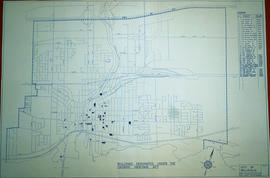
A map of the Buildings Designated under the Ontario Heritage Act in Belleville, Ontario. Created by the Heritage Belleville Committee on November 22, 1985 and revised February 14, 1994. The area includes; the Bay of Quinte north to Highway 401 with designations in the area between Sidney Street and McDonald Avenue.
A research project completed by the Heritage Belleville Committee from October 1993 - February 1994. The project researched designated (red) and non-designated (blue) heritage properties in the West Hill area of Belleville, Ontario.
Videos showing buildings visible from city streets in Belleville and Thurlow wards of the City of Belleville, Ontario. The filming was done in February and March 1998 by camera operator Angela Rowan and drivers Peter Kellett and Reg Stacey.