A certified reproduction of the Plan of Higgins Block, part of Lot # 13 in the 1st Concession of Rawdon Township, for Thomas Jahred Higgins. One building marked “School House” on the west side of Marmora Street. Surveyed by John J. Haslett, P.L.S. in 1853.
This copy was made in 1972 of plan #42, as registered in the Hastings Land Registry Office.
A certified reproduction of the Plan of part of Rawdon (Stirling) Village: the east half of Lot # 11 in 1st Concession of Rawdon Township. Property of Edward Fidlar. Depicted are bridges, buildings of Grist Mill & Saw Mill on Rawdon Creek. Surveyed by John J. Haslett, P.L.S. and signed May 1849.
This copy was made in 1972 of plan #59, as registered in the Hastings Land Registry Office.
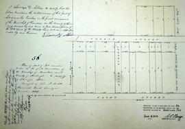
A certified reproduction of the Plan of part of Lot # 12 in 1st Concession of Rawdon Township. Property of Ebenezer D. Allan. Note that this plan became a part of the village of Stirling. Surveyed by John J. Haslett, P.L.S. and signed December 1849.
This copy was made in 1972 of plan #56, as registered in the Hastings Land Registry Office.
A certified reproduction of the Plan of part of Rawdon (Stirling) Village, the north end of Lot # 23 in 9th Concession of Rawdon Township. A tannery is by the shore of Rawdon Creek and buildings are on Wright Street and John Street. An “Old Bridge” & a “New Bridge” extend over the Creek. Surveyed by John J. Haslett, P.L.S. in 1849.
This copy was made in 1972 of plan #54, as registered in the Hastings Land Registry Office.
A certified reproduction of the Plan of part Lot # 12 in 1st Concession of Rawdon, for proprietor Joseph Green. The lot is bounded by Marmora Road, Church Street. the Line between Concessions 11 & 12 and Front Street. Surveyed by John J. Haslett, P.L.S. and signed in December 1849.
This copy was made in 1972 of plan #52, as registered in the Hastings Land Registry Office.
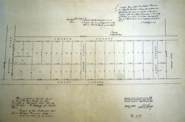
A certified reproduction of the Plan of Allan's Block, part Lot # 12 in 1st Concession of Township of Rawdon (Stirling). Surveyed by John J. Haslett, P.L.S. in 1853.
This copy was made in 1972 of plan #57, as registered in the Hastings Land Registry Office.