
Survey plans transferred from City of Belleville Engineering Department
- CA ON00156 2021-073
- Série organique
- 1974-1999
A series of 506 land registry survey plans for various parcels of land in Thurlow Township.
Survey plans transferred from City of Belleville Engineering Department
A series of 506 land registry survey plans for various parcels of land in Thurlow Township.

Subdivision of part of Lot 13 in the Township of Thurlow
Fait partie de Map collection
A certified reproduction of the "Subdivision of part of Lot # 13, Concession 1, Township of Thurlow, Belleville.” The area includes; Lot # 1 to 11, and Block “A” South of Bridge Street East and West of Haig Road. Surveyed by Walter I. Watson, O. L. S. and signed October 18, 1973.
Donated by Walter I. Watson, P. L. S.
Sans titre

Corporation of Thurlow Map of Roads
Fait partie de Map collection
A map from the Corporation of the Township of Thurlow showing Ontario Hydro lines, concessions and additional country roads. Circa 1970.
Donated by the City of Belleville.

Corporation of Thurlow Map of Wards
Fait partie de Map collection
A map from the Corporation of the Township of Thurlow showing the ten ward boundaries. Circa 1970.
Donated by the City of Belleville.

Old Mill Park Subdivision in the Township Thurlow
Fait partie de Map collection
A certified reproduction of the "Old Mill Park Subdivision: part of Lots # 4 and 5, Concession V, Township of Thurlow, owner Maurice Rollins.” The area includes; Moira River shore to County Road No. 5 and west of Canadian National Railway, being Lots # 1 to 18, Block A-D on Fox Lane and Old Mill Road, Township of Thurlow. Surveyed by Walter I. Watson, O. L. S. and signed July 7, 1968.
Donated by Walter I. Watson, P. L. S.
Sans titre

Subdivision of Part of Lot 17 in the Township of Thurlow
Fait partie de Map collection
A certified reproduction of the "Subdivision of part of Lot # 17, Reg'd Plan No. 769, formerly Township of Thurlow now Belleville.” The area includes; Lot # 1, 2, 3 South of Auburn Street and East of Glendale Road and Northerly from College St. West. Surveyed by Ronald Benn O. L. S. and signed June 7, 1967.
Donated by Walter I. Watson, P. L. S.
Sans titre

Fait partie de HCHS Textual Records collection: Files 2500 to 2999
File contains a typescript note on the status of Thurlow schools by school section, indicating the dates of their establishment and their current use.
Registrar's Plan of part of Lot 3 in the Township of Thurlow
Fait partie de Map collection
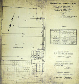
A certified reproduction of the "Registrar's Compiled Plan: Part Lot # 3, Concession 2, Township of Thurlow, now City of Belleville.” The area includes; Lots # 1 to 24, west of North Front Street and north from Tracey Street. Prepared by S.C. Geneja CST, Registry Office, County of Hastings and signed March 23, 1966.
Donated by Walter I. Watson, P. L. S.
Sans titre

Registrar's Plan of part of Lot 3 in the Township of Thurlow
Fait partie de Map collection
A certified reproduction of the "Registrar's Compiled Plan: Part Lot # 3, Concession 2, Township of Thurlow, now City of Belleville.” The area includes; west of North Front Street, and north from College Street West to both sides of Tracy Street.
Prepared by S.C. Geneja CST, Registry Office, County of Hastings and signed March 23, 1966.
Donated by Walter I. Watson, P. L. S.
Sans titre
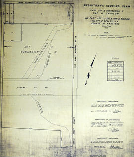
Registrar's Plan of part of Lot 3 in the Township of Thurlow
Fait partie de Map collection
A certified reproduction of the "Registrar's Compiled Plan: part of Lot # 3, Concession 2, Township of Thurlow, now Belleville.” The area includes; west of North Front Street and Hwy 14, south from Road Allowance between Concession 2 & 3,bisected by Hwy 401.
Prepared by S.C. Geneja CST, Registry Office, County of Hastings and signed March 23, 1966.
Donated by Walter I. Watson, P. L. S.
Sans titre

Subdivision of Lots 17-18 in the Township of Thurlow
Fait partie de Map collection
A certified reproduction of the "Subdivision of part of Lots # 17 & 18, Reg'd Plan No. 797...Concession 2 formerly Township of Thurlow, now Belleville, owner Joseph Gajdicar & Sons, Ltd.” The area includes; Lots # 1 to 20, Block A & B, Glendale Road & Ernest Court, being north of Parkdale Drive and west of Lemoine Street. Surveyed by Walter I. Ransom of Ransom & Watson, O. L. S. and signed September 16, 1965.
Donated by Walter I. Watson, P. L. S.
Sans titre

Subdivision of Lot 13 in Township of Thurlow
Fait partie de Map collection
A certified reproduction of the "Subdivision of north half of Lot # 13, Reg'd Plan No. 769, County of Hastings, City of Belleville, formerly Township of Thurlow, [for] owners Ernest A. and Ada C. Hughes.” The area includes; Lots # 1,2, 3, south of Auburn and east of Sidney Streets. Surveyed by Thomas S. Ransom of Ransom & Watson, O. L. S. and signed July 24, 1965.
Donated by Walter I. Watson, P. L. S.
Sans titre

East Park Subdivision in the City of Belleville
Fait partie de Map collection
A certified reproduction of the "East Park Subdivision, part of east half of Lot # 13, Concession 1, formerly Township of Thurlow, now Belleville - owner Lambert Rollins Construction.” The area includes; Lots # 1 to 47, Block A-C, east of Haig Road, with Bridge Street East, Joyce Crescent, Freemont Road. Surveyed by T. S. Ransom O. L. S. (of Ransom & Watson, O. L. S.) and signed April 21, 1965.
Donated by Walter I. Watson, P. L. S.
Sans titre
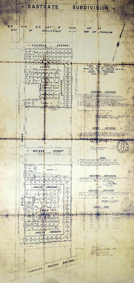
East Gate Subdivision in the City of Belleville
Fait partie de Map collection
A certified reproduction of the "Subdivision of Part of East ½ of Lot # 13, Concession 1, Township of Thurlow, now Belleville laid out for Maple View Realty Ltd. Pres. Maurice Rollins.” The area includes; Lots # 1 to 110 and Blocks A, B, C, D, E, F and Haig Road, Joyce Crescent, Richmond Grove, Janlyn Crescent, Whalen Court, all east of Haig Road. Surveyed by Walter I. Watson, O. L. S. and signed February 10, 1964.
Donated by Walter I. Watson, P. L. S.
Sans titre

Subdivision of part of Lot 14 in the City of Belleville
Fait partie de Map collection
A certified reproduction of the "Subdivision of part of Lot # 14, Reg'd No. 769, formerly Township of Thurlow now Belleville, owner James S. Colligan.” The area includes; Lots # 1, 2, 3 south of Aurburn Street and west of Shamrock Street, being part of Lot # 14. Surveyed by Ronald Benn, O. L. S. and signed April 24, 1964.
Donated by Walter I. Watson, P. L. S.
Sans titre

Subdivision of part of Lots 15-16 in the City of Belleville
Fait partie de Map collection
A certified reproduction of the "Subdivision of part of Lots # 15 and 16, Reg'd Plan No. 769, formerly Township of Thurlow, now City of Belleville.” The area includes; Lots # 1, 2, 3, south of Auburn Street, between Shamrock Street [Road], Glendale Road and north from College Street West. Surveyed by Ronald Benn, O. L. S. and signed January 29, 1964.
Donated by Walter I. Watson, P. L. S.
Sans titre

Subdivision of part of Lot 3 in the Township of Thurlow
Fait partie de Map collection
A certified reproduction of the "Subdivision of part of Lot # 3 Concession V, Township of Thurlow, owner Helen Ash.” The area includes; Lots # 1 to 4 on East shore of the Moira River and North of Road Allowance between Concession 4 & 5, Lot # 3 Thurlow Township Concession 5. Surveyed by Ronald Benn, O. L. S. and signed August 18, 1963.
Donated by Walter I. Watson, P. L. S.
Sans titre

Subdivision of part of Lot 4 in the Township of Thurlow
Fait partie de Map collection
A certified reproduction of the "Subdivision of part of Lot # 4, Concession IV, Township of Thurlow, owner Omar C. Chisholm” The area includes; north side of Farnham Road and west of the eastern limit of Lot # 4, Concession IV being homes 89 to 119 on Farnham Rd. Surveyed by Ronald Benn, O. L. S. and signed March 22, 1963.
Donated by Walter I. Watson, P. L. S.
Sans titre

Leisure Acres Subdivision in the Township of Thurlow
Fait partie de Map collection
A certified reproduction of the "Leisure Acres Subdivision of part of Lot # 1, Concession III, Thurlow, owner Clarence S. Bird.” The area includes; east of road allowance between Townships of Sidney & Thurlow with Lots on Thurlow Drive, Bird Crescent and Leisure Drive. Surveyed by Ronald Benn, O. L. S. and signed March 26, 1963.
Donated by Walter I. Watson, P. L. S.
Sans titre

Map of Southern Hastings County
Fait partie de Map collection
Southern Hastings County in 1963. Map features boundaries, roads and railways. Scale: 1:63,360. Published by the Department of Highways, Ontario. Made by Hunting Survey Corp. Ltd. Dimensions 107.5cm x 92.5cm.
A unique "one-inch" map because all one-inch series maps were converted to 1:50,000 after 1950. However, this map was converted to 1:63,360.
Sans titre