File contains photocopies from The Report of The Bureau of Archieves, published in 1903. Contains lists of claims printed in The Journal of the House of Assembly of Upper Canada (title varies slightly) issued under the following title: Journals of the Legislative Assembly of Upper Canada for the years ... (numbered as vol. 1 (1792/1804)-v. 5 (1821/1824)); the 7th (1910) and 12th (1915) reports include the Journal and proceedings of the Legislative Council of the Province of Upper Canada issued under the following title: Journals of the Legislative Council of Upper Canada for the years ... (numbered as [vol. 1] ((1793/1819) and vol. 2 (1821/1824).
File contains a memorandum dated 20-June-1967 from J. Kidd, Public Archives of Canada, addressed to Robert F. Kirk, subject U.E. Loyalist Lists. The memo indicates the location of these lists.
File contains Bulletin No. 45 of the Departments of History and Political and Economic Science in Queen's University, Kingston, Ontario. Dated May 1923. Formation of division, including Hastings County; Early surveys and surveyors. Donated by Mr. & Mrs. Earl VanBlaricom.
File contains a copy of the “Law for Attainting the Persons, and Forfeiting and Disposing of the Estates of the Loyalists”. It contains the names of the U.E.L. families of the State of New York this law was enacted upon.
This file contains three brochures, and numerous newspaper articles; regarding Upper Canada Village, Quinte – St. Lawrence Parks, and the history surrounding them.
File contains notes written by Carole (Wallbridge) Punchard about the settlement in the Wallbridge Tract of Lower Massassaga. Contains family genealogy information.
Genealogical research materials on members of the Van Blaricom family, United Empire Loyalists and early settlers of Hastings and Prince Edward Counties in Ontario.
This file contains original copy of the Indenture of the conveyance made 20 January 1844 between David Vermilyea of Ameliasburg, Township of Prince Edward County, and Peter W. Merritt of the township of Sidney, for the sale of land and premises in the Township of Huntingdow in the District of Victoria.
A circa 1940 "Clearview" city directory map of Belleville, Ontario. The map features streets, water ways and major city buildings, as seen in the legend. Surveyed by Charles A. Mott, City Engineer. Published by Vernon Directories (Hamilton, Ontario). Heading of the map "Central Ontario Credit Exchange, The home of Collections, East Robertson Block, 219 Front Street, Licenced and Bonded Collection Specialists."
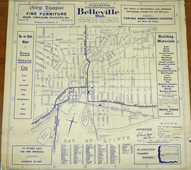
A 1932 "Clearview" city directory map of Belleville, Ontario. The map features streets, water ways and major city buildings, as seen in the legend. Composed by Charles A. Mott, City Engineer. Published by Vernon Directories (Hamilton, Ontario) and Might Directories (Toronto, Ontario). Six advertisements also border the map.
A certified reproduction of the "Victoria Gardens Subdivision - part of east half of Lot # 10, Concession 1, now [the] City of Belleville. Owner- Lambert-Rollins Construction Ltd.” The area includes; north of Victoria Avenue, Lots # 1 to 70 on Rollins Drive and Clifford Crescent. Surveyed by John Thomas Ransom, O. L. S. and signed October 17, 1960.
A regional planning map for the Village of Salem in Thurlow Township, February 1st, 1859. Area extends from concession #8 in lot 12. By Wm Wallbridge, P.L.S. Dimensions 71cm x 32cm. Scale: 1" = 2 chains.
Written in blue ink on the back of flowery wallpaper.
An original plan entitled "Plan of Indian Lands in Tyendinaga Leased 999 Years." Surveyed by William R. Aylsworth, O.L.S. of Belleville. Also written on the plan is "Wallbridge's Plan of Part of Shannonville. Was filed in the Registry Office of Hastings June 21, 1872."
File contains a photocopy of pages from the book “Pioneer Sketches of Long Point Settlement”, written by E.A. Owen, Toronto, 1898. The pages copied are titled “Offshoots of Welsh Nobility-Walsh Family” and appear to be a biography of Francis L. Walsh.
The Wanamaker fonds consists of textual records and graphic materials of genealogical histories of various families. The fonds also contains records, brochures, pamphlets, publications, books, and other textual records from towns and cities throughout Ontario, predominantly from the Quinte Area and Hastings County.
Family Photographs of the Sayers family, Ralph Wanamaker's family, the Hodgen family, of Loral Wanamaker's family, Parliament family, Van Cott family, Post family, as well as loose photographs of the Parliament family, the McTaggart family, various snapshots and negatives of scenery and views, as well as 2 boxes of slides
1 box of Books and Binders with genealogical records, as well various records of various towns in Ontario ca. 1816 - 1957
Genealogical notes, histories, birth records, death records, pages from family Bibles, receipts, and other textual records for over 40 individual families
Genealogical charts, and ancestral charts
Genealogical correspondences *Newspapers, and News clippings from Hastings County, Hastings County Museum, Historical Society, Lennox and Addington, Prince Edward County, Trenton, Tyendinaga, and United Empire Loyalists
Legal documents, seals and original deeds, and land records ca. 1803 - 1848
Genealogy forms, research materials, reference materials
Various artworks and postcards (of Hastings County, the Quinte Region, the British Military and Navy, the Belleville Art Association, and travel)
Quinte region, Belleville, Trenton, and Prince Edward County miscellaneous publications, newspaper clippings, brochures, pamphlets, notes, directories, histories, records, and tourism guides and publications
Ontario, New York , and Canada pamphlets, magazines, calendars, and an Ontario Liquor License Act, 1891
Land Abstracts for Prince Edward County
Maps and plans: 1778-1779 Blue Print Surveys from General Washington, New York Historical Society; 1784 Ontario (printed by Ministry of Natural Resources), 1984; 1860-1861 Hastings County, 1860-1861 from the Hastings County Directory; 1928 Lloyd's Map of Hastings County; c. 1930 Belleville Post Office Carrier Route #8, North Front and North Park Streets
Scrapbooks ca. 1958-1972
Miscellaneous Publications (almanacs, newspaper clippings, miscellaneous pins belonging to Loral Wanamaker, blue print surveys)
Map showing a measured sketch of the water communication between the Bay of Quinte and Lake Huron, May 1818. The total area extends from the Bay of Quinte and Lake Huron by Rice Lake to the falls of the River Trent to its mouth. A reproduction from the Archives of Canada.