Showing 1530 results

Archival description
Land, settlement and immigration
Print preview Hierarchy View:

888 results with digital objects Show results with digital objects

City of Belleville and Advertisements

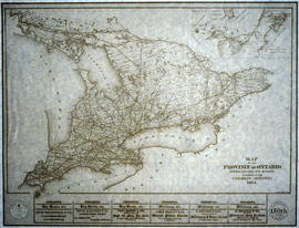
A hand-drawn map of Belleville, Ontario in 1950. The map itself features street names and major water ways. Advertisements surround the map. Published by S. A. Renouf Advertising Co. and drawn by F. P. Lloyd. Scale 1:15,000.

S. A. Renouf Advertising Co.

City of Belleville ByLaw 6495 Zoning Map

A map of the City of Belleville, with the districts based on By Law # 6495 superimposed. The base map is one of Charles A. Mott's, City Engineer.

Mott, Charles Allan

City of Belleville Map with Property Boundaries in 1981

A map of the City of Belleville, including property boundaries, waterways and roads. From the Moira River in the east to the Bay of Quinte south and CNR & North Front Street in the north to Avondale Road in the west. Map composed by the Quinte Planning Board and dated October 1, 1981. Scale 1:4800.

Donated by the Heritage Belleville Committee in 2017.

Quinte Planning Board

City of Belleville on Acme advertisement

A map of the City of Belleville in 1950, on an advertisement for Acme Plumbing. The map itself features street names and major water ways. Street names are at the bottom of the map. Published by S. A. Renouf Advertising Co. and drawn by F. P. Lloyd. Scale 2" : 2,000 feet.

S. A. Renouf Advertising Co.

City of Belleville on hardware advertisement

A map of the City of Belleville in 1950, on an advertisement for Walker Hardware Company Limited. The map itself features street names and major water ways. Street names are at the bottom of the map. Published by S. A. Renouf Advertising Co. and drawn by F. P. Lloyd. Scale 2" : 2,000 feet.

S. A. Renouf Advertising Co.

City of Belleville Zoning By-laws

  • CA ON00156 M/M440-1328 - 1334
  • Item
  • 6 Nov 1976 - 19 Aug 1991
  • Part of Map collection

Key to Zoning By-law Maps of the City of Belleville. Scale: 1:4800. Published by the Quinte Planning Board.
1) M440-1328. Dated 6 Nov 1976. Revised 2 Apr 1991.
2) M440-1329. Dated 6 Nov 1976. Revised 6 Jun 1991.
3) M440-1330. Dated 6 Nov 1976. Revised 19 Aug 1991.
4) M440-1331. Dated 6 Nov 1976. Revised 28 May 1991.
5) M440-1332. Dated 10 Oct 1990.
6) M440-1333. Dated 16 Dec 1985. Revised 21 Feb 1990.
7) M440-1334. Dated 19 Dec 1985. Revised

Quinte Planning Board

CNO Railway from Toronto to Ottawa 1910

A photocopy of a map detailing the CNO railway from Toronto to Ottawa. Dated November 15, 1910. Annotations of proprietors and boundaries have been added to the map.

CNR Crossing at Cannifton Road Blueprint

A blueprint planning the CNR crossing and gas mains at Cannifton Road in Belleville, Ontario. Drawn by Charles Mott - September 21, 1929. Scale: 1" : 4'0.
Features: 4/4/59 Canadian National Railways Agreement as to Laying Pipes Under Track.

Mott, Charles Allan

Comfort Country Map of Hastings County

A excerpt map from a news paper. The map is entitled "Comfort Country" and highlights vacation areas in Stirling, Tweed, Madoc, Marmora. Advertisements on back with numbers to show on Map where it is located.

Commercial Bank Subdivision of Lots 11-19 in Belleville

A certified reproduction of the "Commercial Bank Plan of subdivision of Lots # 11, 12, 13, 14, 15, 16, 17 and 19, of Belleville, being part of Lot # 2 Concession 1 Thurlow." Surveyed by John D. Evans, P.L.S., and dated April 18, 1873.

This copy was made in 1972 of plan #160, as registered in the Hastings Land Registry Office.

Donated by Walter I. Watson, O.L.S.

Evans, John Dunlop, P.L.S.

Copies of documents relating to the Pitman family

  1. 1801 April 25: Certificate by Andrew Embury that Russell Pitman has charge of Lot 12 ir the Third Concession of Thurlow and that no person shall cut or destroy and kind of timber on that lot.

  2. 1801 Dec 29: Copy of Summons from Alexander Fisher to Russell Pitman ordering him to appear in District Court at Kingston on January 13, 1802, to answer the complaint of Reuben Bedell in a "plea of contract" involving a note for £3.2s.7 d.

  3. 1809 Jun 7: Articles of Agreement between (1) John Leslie in the Town of Thurlow" and (2) William Anderson, Thomas Pitman, and Martin Pitman, re: manufacture of 100 bushels of rye into whisky.

  4. 1812 Mar 28: Road Warrant from James McNabb, J.P. and Samuel Sherwood, J.P. to Thomas Pitman, "overseer of roads" informing him of statute labour to be performed on certain roads and bridges in Thurlow Township.

  5. 1820: Unsigned Sample Certificate by John Carter and Martin Pitman regarding the late Russell Pitman's claim to a part of Lot 27 in the Third Concession of Ernestown and stating that his eldest son Thomas Pitman is pro per heir to the land.

  6. 1820: Unsigned Sample Certificate that Thomas Pitman nas 'served faithfully and honestly in the Flank Company of Hastings Militia" and is entitled to Crown land.

  7. 1824 Jan 13: Receipt by Russell Pitman and Diana Pitman for dowe ry payment made to them by Thomas Pitman from the estate of the late Russell Pitman, father of Thomas.

  8. 1837 Nov 27: Letter from James McDonnell to Martin Pitman concerning letter of Christopher A. Hagerman and Pitman's claims for lands granted to his sisters.

  9. 1889 Sep 15: Copy of Subpoena from Robert Pearson to Thomas Pitman, ordering him to appear before the Court of Queen's Bench at Belleville on September 21, to testify in the case of Joseph Thrasher versus David Read.

Copy of a Map of the Province of New York and Jersey

A reproduction of "A New & Accurate Map of the Province of New York and Part of the Jerseys, New England and Canada. Showing the Scenes of our Military Operations during the Prejant War- Also the New Erected State of Vermont." Originally published by J. Bow on October 31, 1780. Date of reproduction is unknown.

Donated by the Belleville Public Library in 2014.

Copy of a Map of the Province of Ontario showing Railways

A reproduction of a "Map of the Province of Ontario Showing Railways now Running." A series of Toronto business advertisements line the bottom of the map. Originally published by the Canadian Almanac in 1884. Reproduced by COPP Clark Professional in January 1997 for the celebration of 150 continuous years of almanac and directory publishing.

Donated by the Belleville Public Library in 2014.

Copp Clark Limited

Copy of Fire Insurance Map 1878

1878 Fire Insurance Map from Charles Goad's Atlas. Details streets, buildings and lots in Belleville, Ontario. Donated by Beth Green.

Chas. E. Goad Company

Results 121 to 140 of 1530