A reproduction of a map of the Township of Monteagle in the County of Hastings. The map features railway lines, Concessions & Lots with the names of residents. The original map was published by the Quebec Department of Lands on July 30, 1862 and revised in 1906.
A map of Hastings County, in 1932, showing lakes, rivers, cities, towns and townships. A list of businesses within the county are on the right. Drawn exclusively for and published by Croydon Publishing Company.
A certified reproduction of the "Tracy Subdivision - being a re-subdivision of Lots # 7 to 15, inclusive as shown on Reg'd Plan No. 797.” The area includes; east side of Sidney Street to Lemoine Street, north side of College Street West and north to include both sides of Tracy Street. Surveyed by Smith & Smith, O. L. S. and signed October 18, 1950.
This copy was made in 1972 of plan #852, as registered in the Hastings Land Registry Office.
An original map produced for the Trenton Electric & Water Co. Limited, concerning proposed transmission lines within the Township of Sidney. However, the map also features railways, roads and land boundaries. Circa 1910. Scale: 50 chains = 1 inch. Map composed by Smith, Kerry and Chace Engineers located in Toronto, Winnipeg, Calgary and Vancouver.
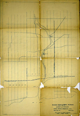
An original map produced for the Trenton Electric & Water Co. Limited, concerning proposed transmission lines within the Townships of Thurlow and Sidney. However, the map also features railways, roads, mills and land boundaries. Dated March 31, 1910. Scale: 1/4 mile = 1 inch. Map composed by Smith, Kerry and Chace Engineers located in Toronto, Winnipeg, Calgary and Vancouver.
The map includes the first 4 concessions, Lots 33-38 in Sidney Township and Lots 1-13 in Thurlow Township.
An original map produced for the Trenton Electric & Water Co. Limited, concerning their water mains, towers and substations within the Township of Thurlow. However, the map also features railways, roads and land boundaries. Circa 1910. Scale: 50 chains = 1 inch. Map composed by Smith, Kerry and Chace Engineers located in Toronto, Winnipeg, Calgary and Vancouver.
A reproduction of an air survey photograph produced by the Ontario Ministry of Natural Resources. Map # 443771W of Tyendinaga Township in Hastings County, Ontario. Circa 1950.
The photograph shows Lonsdale, Melrose and north to Concession 8, Township of Tyendinaga.
Donated by Walter I. Watson, P. L. S.
Ontario. Ministry of Natural Resources and Forestry
A circa 1940 "Clearview" city directory map of Belleville, Ontario. The map features streets, water ways and major city buildings, as seen in the legend. Surveyed by Charles A. Mott, City Engineer. Published by Vernon Directories (Hamilton, Ontario). Heading of the map "Central Ontario Credit Exchange, The home of Collections, East Robertson Block, 219 Front Street, Licenced and Bonded Collection Specialists."
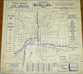
A 1932 "Clearview" city directory map of Belleville, Ontario. The map features streets, water ways and major city buildings, as seen in the legend. Composed by Charles A. Mott, City Engineer. Published by Vernon Directories (Hamilton, Ontario) and Might Directories (Toronto, Ontario). Six advertisements also border the map.
A certified reproduction of the "Victoria Gardens Subdivision - part of east half of Lot # 10, Concession 1, now [the] City of Belleville. Owner- Lambert-Rollins Construction Ltd.” The area includes; north of Victoria Avenue, Lots # 1 to 70 on Rollins Drive and Clifford Crescent. Surveyed by John Thomas Ransom, O. L. S. and signed October 17, 1960.
A regional planning map for the Village of Salem in Thurlow Township, February 1st, 1859. Area extends from concession #8 in lot 12. By Wm Wallbridge, P.L.S. Dimensions 71cm x 32cm. Scale: 1" = 2 chains.
Written in blue ink on the back of flowery wallpaper.
An original plan entitled "Plan of Indian Lands in Tyendinaga Leased 999 Years." Surveyed by William R. Aylsworth, O.L.S. of Belleville. Also written on the plan is "Wallbridge's Plan of Part of Shannonville. Was filed in the Registry Office of Hastings June 21, 1872."
An original, waxed linen map entitled "Plans of Islands claimed by the band of Alnwick Indians. Pursuant to Instructions bearing date “Crown Lands Department” Quebec 2nd October 1861." The area in mention concerns Weller's Bay and Hay Bay, in Prince Edward County. Surveyed by John McNaughton, P. L. S. in April and May 1862. Scale: 8 chains to an inch.
An original, waxed linen map entitled "Islands claimed by Alnwick Indians, Pursuant to Instructions bearing date Crown Lands, Dept. Quebec 2nd October 1861." The area in mention concerns the West Lake Islands, in Prince Edward County. Surveyed by Duncan McDonell Greenfield and John McNaughton, P. L. S. in May and June 1862. Scale: 8 chains to an inch.
A map showing, primarily, zoning limits within the City of Belleville. The limits are coloured in crayon and can be referenced on the legend (left). The map was first created c. 1959 (as written in pencil). However, more recent revisions were made June 4, 1970. Scale: 1:12,000. Additional information about by-laws is available on the map's border.
Note the two names listed on the top left corner: K. Murray and D. Williams - possible authors or owners.