
Corby's Has Oldest Firm Distinction
- CA ON00156 TR/0924/3
- Item
- [c.1965]
A newspaper article about the Corby Distillery and its history.
Corby's Has Oldest Firm Distinction
A newspaper article about the Corby Distillery and its history.

H. Corby Distillery Ltd. 1968 Annual Report
1968 annual report for the Corby Distillery
H. Corby Distillery Ltd.

Corby's “The Home of Good Spirits” 1960
File contains a magazine, “The Home of Good Spirits”, published by the Corby Distillery in 1960.
Corby's Distilleries

File contains a newspaper clipping about the reforestation of the Corby Distillery farm.

Mackenzie Bowell bill with letter head 1865
File contains an 1865 printing bill from the Intelligencer to Mackenzie Bowell.

File contains 2 newspaper clippings about Deacon Shirt Co. - a 1934 article advertising the local Belleville business, and a 1968 article on Mrs. Elizabeth McEvoy, long time employee of Deacon Shirt Co. Being honored.
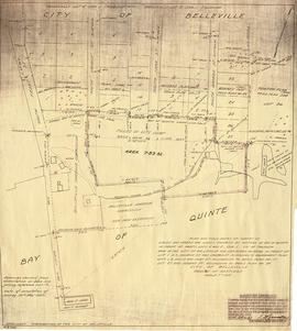
Map of planned Belleville Harbour
Part of Map collection
A map showing a plan for the Belleville Harbour. The total area stretches from south Front Street to the Ponton Plan. Published by John T. Ransom on May 19th, 1947. The map features field notes of survey of lands, marshes and Bay of Quinte waters. Scale: 1':100'.
Ransom, John Thomas, P.L.S.

Dominion of Canada with Hudson's Bay areas
Part of Map collection
A Map of the Dominion of Canada Shewing the Establishments of the Hudson's Bay Company. Scale: 1:10,500,00. Note the presence of the Districts of Mackenzie, Keewatin and Franklin and the border of Manitoba - circa 1905.

Bird's Eye View Map of Belleville
Part of Map collection
Reproduction by the Hastings County Historical Society of an 1874 Bird's Eye View of Belleville, Ontario, showing buildings that existed at that time.
The original map was drawn by Herman Brosius and printed by Charles Sober & Co. of Chicago.
Plot Plan in the City of Belleville in 1960
Part of Map collection
A plan of a plot in the City of Belleville. Some of the buildings on site include Zellers, A and P, Reitmans. The plot is located between Dundas Street and Bridge Street. Published December 30, 1960 by Principal Investments Ltd., General Contractors.
Donated by the Belleville Public Library in 2014.

Photocopies of 1865 Edwin Whitefield sketches of Belleville, made from originals at Library and Archives Canada. Flyer from Foster, Barber and Brignall, dry goods store at the northwest corner of Bridge and Front Streets, Belleville, Ontario (listed at this location in the 1877 directory: https://archive.org/details/bellevilledirect1877hooguoft/page/32) [202 Front Street in 2019].

Carre's Plan of the city of Belleville 1892
Part of Map collection
A copy of a map planning streets and buildings in Belleville, Ontario, 1892. The total area extends from Belleville to Bay of Quinte to Bridge Street (sheet 2) and from Bridge Street to Concession Road Allowance - now College Street - (sheet 1). Surveyed by Henry Carre, Ontario Land Surveyor.
Scale: 10 chains to an inch.
Carre, Henry, O.L.S.

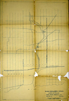
Trenton Electric & Water Co. Limited in Sidney Township
Part of Map collection
An original map produced for the Trenton Electric & Water Co. Limited, concerning proposed transmission lines within the Township of Sidney. However, the map also features railways, roads and land boundaries. Circa 1910. Scale: 50 chains = 1 inch. Map composed by Smith, Kerry and Chace Engineers located in Toronto, Winnipeg, Calgary and Vancouver.
Donated by David Pershick.
Smith, Kerry and Chace Engineers

Seymour Power & Electric Co. Limited in Murray Township
Part of Map collection
An original map produced for the Seymour Power & Electric Co. Limited, concerning proposed transmission lines within the Township of Murray. However, the map also features railways, roads, mills and land boundaries. Circa 1910. Scale: 50 chains = 1 inch. Map composed by Smith, Kerry and Chace Engineers located in Toronto, Winnipeg, Calgary and Vancouver.
Donated by David Pershick.
Smith, Kerry and Chace Engineers
Trenton Electric & Water Co. Limited in Thurlow and Sidney Townships
Part of Map collection
An original map produced for the Trenton Electric & Water Co. Limited, concerning proposed transmission lines within the Townships of Thurlow and Sidney. However, the map also features railways, roads, mills and land boundaries. Dated March 31, 1910. Scale: 1/4 mile = 1 inch. Map composed by Smith, Kerry and Chace Engineers located in Toronto, Winnipeg, Calgary and Vancouver.
The map includes the first 4 concessions, Lots 33-38 in Sidney Township and Lots 1-13 in Thurlow Township.
Donated by David Pershick.
Smith, Kerry and Chace Engineers

Trenton Electric & Water Co. Limited in Thurlow Township
Part of Map collection
An original map produced for the Trenton Electric & Water Co. Limited, concerning their water mains, towers and substations within the Township of Thurlow. However, the map also features railways, roads and land boundaries. Circa 1910. Scale: 50 chains = 1 inch. Map composed by Smith, Kerry and Chace Engineers located in Toronto, Winnipeg, Calgary and Vancouver.
Donated by David Pershick.
Smith, Kerry and Chace Engineers

Town of Trenton with advertising businesses
Part of Map collection
A photocopy of a map of the Town of Trenton, circa 1915. The map features advertisements for local businesses, important sites, industries and many railways and stations.
Donated by Bruce Polmanter.
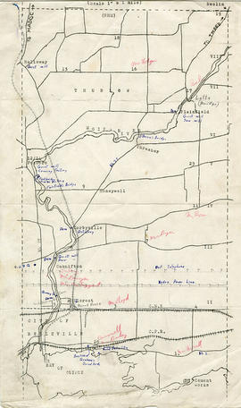
Map of Thurlow Township with annotations
Part of Map collection
A map of Thurlow Township featuring the addition of handwritten annotations. Concessions, railways, proprietors, businesses and locations are featured. The map extends from the Bay of Quinte in the southwest to Roslin the northeast. Circa 1950 (Bakelite plant opened c. 1948 and the Foxboro Cheese Factory closed in 1961).
Specific annotations are as follows: Halloway Grist Mill, Latta Bridge, Plainfield Grist, Saw Mill, O'Brien's Bridge, Grist Mill, Canning Factory Foxboro, Footbridge, Cheese Factory, Fairfields Bridge, Dam Corbyville, Distillery, Cannifton Dam, Grist & Saw Mill, Quarry & Substation, Round House, Brickyard, Graham's Dried Foods, Bell Telephone Lines, Hydro Power Lines, and Cement Works.

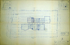
Floor plans for L. W. Yeoman's Drug Store
Part of Map collection
An original hand-painted, paper set of floor plans. The plan was drawn in 1873 for L. W. Yeoman & Company's drug store. The store was located on the corner of Front and Market Streets. The drawings cover the plans for the foundation, ground, second and third floors. Scale: 8 feet to one inch. Published by H. Belden & Company. John Forin built the building.
H. Belden & Company

Deseronto Town Hall photograph collection
Photographs of Deseronto, Ontario dating from the 1970s to 2011, depicting a variety of Town events. They include a set of aerial photographs of the town from the 1980s; the interior of the former Home Hardware store in the Baker Block on Main Street; the O’Connor House on Main Street before its demolition; the 1989 100th Anniversary celebrations, photographs of Centennial Park and Rathbun Memorial Park; the opening of the Deseronto Public Library in its 358 Main Street location in 2001; the Ontario Provincial Police handover ceremony in 2001; an Easter Parade from the early 2000s; a Santa Parade; the 2002 New Year’s Levee; and the 2010 Olympic Flame run in Deseronto.
Most of the photographs appear to have been taken by Town staff. One envelope was donated to the Town by Irene Usher and contains photographs taken by her late husband, Tom.