Showing 133 results

Archival description
Madoc, Township of
Print preview Hierarchy View:

49 results with digital objects Show results with digital objects

Hydro-Electric Power Commission of Ontario, Tweed-Section

  • CA ON00156 M/M430-2995 - 2996, 3018 - 3021, 3031/3018
  • Item
  • 16 Oct 1951
  • Part of Map collection

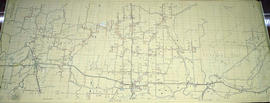
An original map produced for the Hydro-Electric Power Commission of Ontario, concerning hydro power lines, stations and transformers. However, the map also features railways, roads and land boundaries.

This map is the West Centre Section - Tweed ROA. The total area includes parts of Rawdon, Marmora, Huntingdon, Madoc, Hungerford, and Elzevir Townships. Dated October 16, 1951. Scale: 1.2 inches = 1 m.

Donated by David Pershik.

Madoc : history and churches

File contains a newspaper clipping and photocopied manuscript history of Madoc Township from early French exploration in 1615 to ca. 1965, including a discussion of the creation of roads, schools and local churches. The historical research was composed by Mrs. Ken Bateman for Gerry Boyce as background for Historic Hastings.

Madoc : O'Hara's pioneer home

File contains printed announcements and booklets concerning the opening of O'Hara's Mill Conservation Area in July 1957, the restoration of the property and the official opening of the pioneer house in July 1969. Also contains several newspaper clippings regarding the restoration of the pioneer home.

O'Hara's Mill Conservation Area

File contains printed booklets entitled respectively, “The Official Opening of the O'Hara Mill Conservation Area...Wednesday, July 24th, 1957,” and “O'Hara Mill : An Historical Monument Being Preserved by the Moira River Conservation Authority,” the latter of which contains photographs of the Mill and associated artifacts. Also included is a photocopied booklet entitled “The O'Hara Mill Project," by the Moira River Conservation Authority, 1956. Also present are several newspaper clippings regarding the restoration of the O'Hara Mill in the 1950s .

Royal Visit

The file contains three newspaper clippings about the Royal Visit of Queen Elizabeth II and Prince Philip to Kingston. Included in the articles are references to the Tyendinaga Mohawk Territory and presentations by the Indigenous people. Also, during the same visit, in Toronto the meeting of the Royals with Peter Ramsay of Madoc.

Geological Map of the Madoc and Gananoque areas

2 maps showing geological areas in Madoc (Map No. 2053) and Gananoque (Map No. 2053). Scale 1 in to 2 miles. Booklet by D. F. Hewitt, Senior Geologist, Ontario Department of Mines, Toronto.

Ontario. Ministry of Natural Resources and Forestry

Aerial Photograph of Madoc Township

  • CA ON00156 M/M470-2781 - 2794/2781
  • Item
  • c. 1977
  • Part of Map collection

Madoc Township, Map # A18256-148 showing areas of Hwy 62 at Bannockburn and the road east to Cooper. The railway parallel with Hwy 62. The Ontario Hydro easement running west from Cooper. By the Air Photographic Production Division of the Deptartment of Mines & Technical Surveys - Government of Canada.

Canada. Department of Mines and Technical Surveys

Aerial Photograph of Madoc Township

  • CA ON00156 M/M470-2781 - 2794/2782
  • Item
  • c. 1977
  • Part of Map collection

Madoc Township, north part Bannockburn with Hwy 62, the railway, and the Bannockburn Road running east toward Cooper. By the Air Photographic Production Division of the Deptartment of Mines & Technical Surveys - Government of Canada.

Canada. Department of Mines and Technical Surveys

The Gladys Rollins Collection

This file contains: 1) A photocopied typed article titled "Telegraph Island Light", about the lighthouse erected 1870 in the Bay of Quinte; 2) A timetable for the steamer Varuna, circa 1920, Captain A. Hicks; 3) A photocopy of the obituary for Rev. James Rollins born 28 October 1865 in Madoc and died 7 February 1943 in Kingston.

Results 61 to 80 of 133