
Sketch of the mill privileges at Coleman's dam
- CA ON00156 TR/0915-1/0915-1
- Pièce
- 18, October, 1873
Fait partie de HCHS Textual Records collection: Files 1 to 999
Sketch of the mill privileges of Coleman's dam on the west side of the Moira River
888 résultats avec objets numériques Afficher les résultats avec des objets numériques
Sketch of the mill privileges at Coleman's dam
Fait partie de HCHS Textual Records collection: Files 1 to 999
Sketch of the mill privileges of Coleman's dam on the west side of the Moira River

Fait partie de HCHS Textual Records collection: Files 1 to 999
File contains a history/biography on William Bell and his role in the settlement of the Bay of Quinte. Identified as part of the W. C. Mikel papers.
Sans titre
Belleville – 1789 to 1812 by Gerry Boyce “A settlement at Meyer's Creek"
Fait partie de HCHS Textual Records collection: Files 1 to 999
Typescript draft of "A Settlement at Meyers' Creek" (Chapter 6 of Historic Hastings by Gerry Boyce), with annotations and suggestions by H. C. Burleigh.
Sans titre
Belleville – Crown patents for City Lots
Fait partie de HCHS Textual Records collection: Files 1 to 999
File contains lists of patents for Crown grants for lots within the Corporation of the City of Belleville.

Belleville – Early settlers – Meyer's Creek
Fait partie de HCHS Textual Records collection: Files 1 to 999
File contains a history of the early settlers of Meyer's Creek written by Allan Dempsey.
Sans titre
Belleville 1832; Letter re Land Grants to Immigrants
Fait partie de HCHS Textual Records collection: Files 1 to 999
File contains a letter written to Gerry Boyce in regards to enquires he made about land grants for immigrants during 1832.
Fait partie de HCHS Textual Records collection: Files 1 to 999
File contains a c.1905 map of Belleville city streets and lots.
Fait partie de HCHS Textual Records collection: Files 1 to 999
File contains copies of a 1816 map of plots laying out the town of Belleville.
Tax Sale Deed & Poster 1864-1887
Fait partie de HCHS Textual Records collection: Files 1 to 999
File contains an 1887 Treasurer's Deed to Thomas Callard(?) Luscombe from Wellington Jeffers Diamond and Robert Taunahill(?) of the City of Belleville; and a “Sheriff's Sale of Lands” poster from 1864.
Fait partie de HCHS Textual Records collection: Files 1 to 999
File contains biographical information of Anthony Burgess, an immigrant from Portugal who lived in Thurlow and was a sheep breeder in the 1870s.
Canada – the formative years 1812-1871; Imperial Review 1967
Fait partie de HCHS Textual Records collection: Files 1 to 999
File contains a book published in 1967 titled “Canada 1812-1871: The Formative Years”.
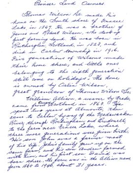
Carlow Township – pioneer land owners
Fait partie de HCHS Textual Records collection: Files 1 to 999
File contains information of pioneer land owners and their families in Carlow Township.
Coleman, Thomas – deed to Everett H. Coleman 1854
Fait partie de HCHS Textual Records collection: Files 1 to 999
File contains 1854 deed of sale from Thomas Coleman to Everett H. Coleman.
Deed of sale 1854-1878 Nugent-Pake-Covert
Fait partie de HCHS Textual Records collection: Files 1 to 999
File contains a deed of sale between Nugent-Pake-Covert in Belleville.
Murray Township : surveyor's notes
Fait partie de HCHS Textual Records collection: Files 2000 to 2499
File contains manuscript field notes of an 1884 survey of the Trent River in the Township of Murray in the Newcastle District by Provincial Land Surveyor, F.P. Rubidge.
McClure Township : field notes 1858-1870
Fait partie de HCHS Textual Records collection: Files 2000 to 2499
File contains a microcopied manuscript diary and field notes of the township of McClure, 1858 by J.S. Peterson, Provincial Land Surveyor. Also contains a microcopied manuscript report and field notes of the township of McClure. 1870 by Cosford Chalmers Forneri and Lachlan Kennedy, Provincial Land Surveyors.

Fait partie de Map collection
A regional planning map for the Village of Salem in Thurlow Township, February 1st, 1859. Area extends from concession #8 in lot 12. By Wm Wallbridge, P.L.S. Dimensions 71cm x 32cm. Scale: 1" = 2 chains.
Written in blue ink on the back of flowery wallpaper.
Donated by Mrs. R. Sills.
Sans titre

Fait partie de Map collection
A map showing concessions and lots of Huntingdon - Madoc Township, Hastings County. Circa 1869. 30 advertisements for companies surround the map. Published by Macleod and Carre, Engineers and Surveyors. Scale: 1:63,000. Dimensions: 34.0cm x 37.0cm. Map was created from Government plan.
Donated from the Col. W. N. Ponton Estate. Penciled notes on map show Ponton family's interest in mining, especially after the Eldorado Gold Rush in 1866.
Sans titre

Fait partie de Map collection
A map of Sidney Township, the Plan of Lots on Gladstone Avenue/Trent Road, 1912. Published by Lucien & Allen C.E. on January 2nd, 1912. Created by A.W. Ponton, P.L.S. Scale: 100 feet : 1 inch.
Sans titre

Plan 204 - Brown Block, Belleville, Ontario
Fait partie de Map collection
Copy of plan 204 registered in the Hastings County Land Registry Office, showing the Brown Block between Sidney Street (Townline Street) and Wilkins Street in Belleville, Ontario. The plan was drawn up by Evans and Bolger for James W. Brown, a tailor.
Sans titre