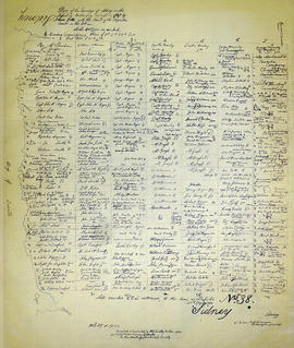
- CA ON00156 TR/3849/1
- Item
- 27 February 1809
Sale of the eastern half of lot 37 in the second concession of Sidney Township by Anthony Ostrum of New York State, yeoman, to Roswell Leavens of Thurlow Township, blacksmith.
91 results with digital objects Show results with digital objects
Sale of the eastern half of lot 37 in the second concession of Sidney Township by Anthony Ostrum of New York State, yeoman, to Roswell Leavens of Thurlow Township, blacksmith.
Jellett, Morgan; documents – mort. Etc.
File contains various documents that belonged to Morgan Jellet, such as Land Deeds for property in Sindey and Assignment of Mortgage.
File contains a newspaper article that features the history of the Ketcheson family farm and cemetery in Sidney. The farm had been in the family since the early 1800s.
Ketcheson family; funeral cards
File contains the funeral cards for Everett Ketcheson (b. 1891, d. 1914) and Edward Ketcheson (b. 1832, d. 1915). There is also a book published in 1958, “The Ketcheson Family”, a newspaper article from 1968 about Mr. and Mrs. Lawrenson L. Ketcheson celebrating their 60th wedding anniversary, and an invite for the Ketcheson family reunion in 1965 at the Memorial Park in Tweed.
Ketcheson, Elijah; reunions & birthdays
File contains information about Col. Elijah Ketcheson (b. 1793) of Sidney. There are also newspaper clipping about the Ketcheson family reunion in 1962 in Tweed and Fred A. Ketcheson celebrating his 90th Birthday. There are two invitation to Mr. and Mrs. Gerald Boyce for the Ketcheson family reunion in 1959 and 1961, as well as information about the family reunion in 1964.
Ketcheson, William & Mary family
File contains the family history of William and Mary Ketcheson (nee Rull), married 1779, formerly of Sidney and latterly of Belleville.

Lloyd's Map of Hastings County
Part of Map collection
A map of Hastings County outlining the twelve townships:
Marmora and Lake, Madoc, Tudor, Grimsthorpe, Elzevir; Rawdon, Huntingdon, Hungerford, Sidney, Thurlow, Tyendinaga. The northern townships are pictured on the right side.
As well as, the lots and concessions. Circa 1922. Scale: 1.5 miles: 1 inch. Published by Lloyd's Maps, Map Publisher.
Lloyd's Map, Map Publisher

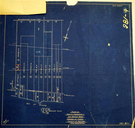
Lot Division Map of Sidney Township
Part of Map collection
A lot division map of Sidney Township in Hastings County, Ontario. Published by the Department of Land Surveys on August 18th, 1944. Scale: 1=4,000.
Bottom right corner reads "Dominion of Canada, War Assets Corporation" and discusses a storage yard location on Lot 3, Concession 1.
Department of Land Surveys
Map 3 from the Hydro Comission Route Inquiry
Part of Map collection
A map studying the proposed routes for power transmission from Lennox to Oshawa. The area covers from West Oshawa, East Mount Pleasant Jct. North Rice Lake & South Lake Ontario.
Solandt Commission Inquiry

Map of District of Prince Edward County
Part of Map collection
Map showing townships in the District of Prince Edward County: South Murray, Sidney, Thurlow, Ameliasburgh, Sophiasburgh. See boundary lines on map. Surveyed by Publius Virgillius Elmore, D.L.S. Dated 1835. Map copied from the Archives of Ontario.
Elmore, Publius Virgillius, D.P.S.
Map of Expropriated Land for Trenton Air Base
Part of Map collection
A map of Sidney Township, part of Concession #1 and Broken Front, October 18th, 1912. The map details a tract of land expropriated for Trenton Air Base. Scale: 12.5 chains : 1 inch.
Attached is a letter dated May 1st, 1931, The King versus Maitland Hutton and Leda Hutton.

Map of Hastings County in 4 sections
Part of Map collection
A map of Hastings County outlining townships from the Bay of Quinte in the south, to Wallaston, Limerick and Cashel in the north.
Map is in four sections. Scale: 3 miles : 1 inch. Original map is dated 1894. Photocopy from the Archives of Ontario.

Map of Hastings with the Principal Villages and the City of Belleville
Part of Map collection
A map of Hastings County including the Town of Belleville and other principal villages:
Trenton, Madoc, Marmora, Tweed, Bridgewater, Stirling, Wicklow, Bangor, Herschel, Monteagle, Carl, Dungannon, Wollaston, Limerick, Cashel, Tudor, Grimsthorpe, Elzevir; Rawdon, Huntingdon, Hungerford, Sidney, Thurlow, Tyendinaga.
Scale: 3 miles =1 inch. Published by Evans & Bolger, P. L. Surveyors, P.L.S. in 1879-1880.
Evans and Bolger

Map of Hastings with townships
Part of Map collection
A map of Hastings County outlining the twelve townships:
Marmora and Lake, Madoc, Tudor, Grimsthorpe, Elzevir; Rawdon, Huntingdon, Hungerford, Sidney, Thurlow, Tyendinaga.
As well as, the lots and concessions. Circa 1916.Scale: 4 miles: 1 inch.
Donated by K.G.M. Ross.

Map of Sidney and Thurlow Townships
Part of Map collection
This original map displays early township lots and proprietor names of Sidney and Thurlow Townships. Its date of creation is estimated to be between 1858-1863. Scale: 1:47,000.
Note that by observing the border, this map looks as if it was apart of a larger map. This is the only known copy.

Part of Map collection
A map of Sidney Township featuring lots, concessions, roads, nearby towns and the Canadian National Railway.

Part of Map collection
A map of Sidney Township, specifically the District of Mecklenburg in 1787. Contains information on the plans for the 1st, 2nd, and 3rd concessions, as well as property owners. Created by Lewis Kotte, Deputy Provincial Surveyor. Scale: 40 chains to an inch.
Kotte, Lewis
Map of Sidney Township in 1787 - 1981 rewrite
Part of Map collection
A recopy of the 1787 map of Sidney Township. The original map entitled "Plan of the Township of Sidney in the District of Mecklinburg. Surveyed in 1787 by Lewis Kotts, with the names of the proprietor inserted in the Lots." The recopy was completed by Mrs. Dorothy Ashton in 1981, for the Corby Public Library and Hastings County Historical Society. Scale 40 chains to an inch.
Donated by the Belleville Public Library in 2014.
Kotte, Lewis

Map of Southern Hastings County
Part of Map collection
Southern Hastings County in 1963. Map features boundaries, roads and railways. Scale: 1:63,360. Published by the Department of Highways, Ontario. Made by Hunting Survey Corp. Ltd. Dimensions 107.5cm x 92.5cm.
A unique "one-inch" map because all one-inch series maps were converted to 1:50,000 after 1950. However, this map was converted to 1:63,360.
Ontario. Department of Highways

Map of the Counties of Hastings and Prince Edward
Part of Map collection
A "Map of the Counties of Hastings and Prince Edward." In 1898, the lots, concessions, churches, schools and mines are shown of the townships in Hastings and Prince Edward. Scale: 1.5 miles to an inch. Published by the Canadian Map Publishing Company in Hamilton, Ontario, for the Belleville Sun. Revised by Henry Carre, C.E. Inset is the map of North Hastings, scale 400 chains to an inch.
Carre, Henry, O.L.S.