Showing 720 results

Archival description
Government
Print preview Hierarchy View:

136 results with digital objects Show results with digital objects

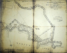
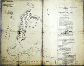
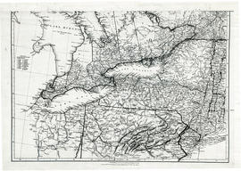
Ontario Federal Constituencies

A map showing the members of parliament to the federal constituencies of Ontario, Canada. Published by External Policy Implementation Committee of Ontario Secondary School Teachers Federation.

Ontario Historical Society Records, Vol. L, #3, 1958

File contains a print copy of Ontario Historical Society Records, Volume L Number 3. This issue includes information about Samuel Bealy Harrison, a political reformer; the Midewiwin, Ontario's first Medical Society; History of Froomefield, Moore Township; The War of 1812; Horse Thieves, Pirates and Witches; and minutes from the annual meeting.

Ontario Historical Society Records, Vol. LI, #4, 1959

File contains a print copy of Ontario Historical Society Records, Volume LI Number 4. This issue includes information about John Rolph, political reformer who was aware of the Upper Canada Rebellion; an 1837 letter from Government House, Toronto; Catholic Missionary Labours on the Lake Superior Frontier, 1667-1751; the Diary of Henry Ransford; Four Canadian Soldiers that Fought in the American Civil War; and functions and operations of the Historical Branch.

Palmer Gardens Subdivision in the City of Belleville

A certified reproduction of the "Palmer Gardens subdivision...Registrar's compiled Plan 1824 formerly in Township of Sidney now Belleville.” The area includes; East of Palmer Road and Northerly from Leland Drive to Bridge St. West, being Lots # 1 to 126, Blocks A-K and streets Dunnet Boulevard, O'Hare St, Hope Crescent, Robertson Lane. Surveyed by Lloyd Parker, O. L. S. and signed April 25, 1969.

Donated by Walter I. Watson, P. L. S.

Parker, Lloyd Edward George, O.L.S.

Part 1 of the Subdivision of Part of Lots 22-24 in the Township of Cashel

A certified reproduction of the "Subdivision of Part of Lots # 22, 23, & part of Broken Lot # 24, Concession 5, Township of Cashel and part of Lot # 22 & part of Broken Lots # 23, 24, Concession 4, Township of Cashel.” The area includes; northeast shore of Gunter Lake, east from the Narrows Little Salmon Lake (Cashel Lake) and along the shore to the creek. Surveyed by Browne, Cavell and Jackson, O.L.S. and signed October 28, 1963.

Donated by Walter I. Watson, P. L. S.

Browne, Cavell and Jackson Ltd.

Part 2 of the Subdivision of Part of Lots 22-24 in the Township of Cashel

A certified reproduction of the "Subdivision of part of Lots # 22 & 23 & part of Broken Lots # 24, Concession 5 and Part of Lot # 22 & part of Broken Lots # 23 & 24, Concession 4, Township of Cashel. For Owner High Pine Developments, Muriel O. Therrian, Pres." The area includes; Lots # 29 to 43 & Block D along the east shore of Cashel Lake (Little Salmon Lake) near the narrows. Surveyed by William Jackson, O.L.S. of Browne, Cavell and Jackson, O.L.S. and signed October 24, 1963.

Donated by Walter I. Watson, P. L. S.

Jackson, William, O.L.S.

Parts of Ontario and USA in 1834

A map showing settlements of Ontario and part of the United States in February 1834 by J. Arrowsmith. The total area extends from Lake Huron East to Montreal and south Ohio to Long Island.
Received from the Archives of Canada's map collection - 11 May 1977.

Arrowsmith, John

Petition of J. W. D. Moodie & others

Petition of the state of a road leading to 2nd Concession of Sidney, signed by J. W. Dunbar Moodie, William Symons, Benjamin Hinker, William Haddrell, Joseph Bedford, G. Booth, James Booth, Farley Ellis, Robert Bennett, James Winelett, William Harris, Daniel Perry, Walter Lackie, and W. Tofrell.

Plan of Easements Lot 1-86 in Trenton

A certified reproduction of the "Compiled Plan of Easements, Part of Lots # 1 to 86 & part of Blocks B & C. Reg. Plan No. 1946, Town of Trenton.” The area includes; East of Byron Street & including Connolly Avenue, Shoniker Avenue, Nelles Avenue. Surveyed by Edward C. Carter, O. L. S. (Carter Horwood Ltd. , O. L. S.) and signed August 13, 1971.

Donated by Walter I. Watson, P. L. S.

Carter, Edward Christian, O.L.S.

Plan of Re-subdivision of Lot 7-24 in the Town of Trenton

A certified reproduction of the "Plan of Resubdivision of Lots # 7 to 24 inclusive and Lot # 48, Bowen Crescent, Downs Park Ave and Coulter Crescent as shown on Reg. Plan 775, Trenton, owner Downs Coulter & Co. (Canada) Ltd.” The area includes; Trenton- Lots # 7 to 31 on Coulter Crescent, North of Prince Charles School grounds and Westerly from Dufferin St. to Hanna Park. Surveyed by W. J. Pattison, O. L. S. and signed July 22, 1965.

Donated by Walter I. Watson, P. L. S.

Pattison, William James, O.L.S.

Plans for Schedules A-F in the City of Belleville

  • CA ON00156 M/M440-1344 - 1349
  • Item
  • Aug 1974 - 1990
  • Part of Map collection

Schedule plans A - F for the City of Belleville. Researched by the Quinte Planning Board. Published by Totten Sims Hubick; Associates Limited. All maps must be read in conjunction with the associative text provided.
1) M440-1344. Dated Jul 1988. Schedule A - Planning Districts and Planning Units. Scale 0-1000:4".
2) M440-1345. Dated Aug 1974. Revised Jan and Oct 1975. Schedule B - Land Use Plan. Scale 1" : 800ft.
3) M440-1346. Dated Aug 1974. Revised Jan and Oct 1975. Schedule C - Recreation Plan. Scale 1: 9600.
4) M440-1347. Dated Aug 1974. Revised Jan and Oct 1975. Schedule D - Residential Density Plan. Scale 1: 9600.
5) M440-1348. Dated Aug 1974. Revised Jan and Oct 1975 and Sep 1986. Schedule E - Transportation Plan. Scale 1: 9600.
6) M440-1349. Dated 1990. Schedule F - Municipal Services Plan. Scale 1: 9600.

Totten Sims Hubicki Associates Limited

Results 521 to 540 of 720