Showing 177 results

Archival description
Thurlow, Township of Image
Print preview Hierarchy View:

177 results with digital objects Show results with digital objects

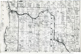
Map of Southern Hastings County

Southern Hastings County in 1963. Map features boundaries, roads and railways. Scale: 1:63,360. Published by the Department of Highways, Ontario. Made by Hunting Survey Corp. Ltd. Dimensions 107.5cm x 92.5cm.

A unique "one-inch" map because all one-inch series maps were converted to 1:50,000 after 1950. However, this map was converted to 1:63,360.

Ontario. Department of Highways

School Section Boundaries in Thurlow Township

A map of the boundaries of school sections in Thurlow Township, December 1859. The sections are colourized polychrome. Concessions and main bodies of water are marked. By John Emerson, P.L.S. Dimensions 22.0cm x 35.0cm.

Donated by Albert Stapley in Belleville, July 1962.

Emerson, John, P.L.S.

Hastings with Town of Belleville and principal villages

A map of Hastings County including the Town of Belleville and other principal villages:

Trenton, Madoc, Marmora, Tweed, Bridgewater, Stirling, Wicklow, Bangor, Herschel, Monteagle, Carl, Dungannon, Wollaston, Limerick, Cashel, Tudor, Grimsthorpe, Elzevir; Rawdon, Huntingdon, Hungerford, Sidney, Thurlow, Tyendinaga.

Scale: 3 miles =1 inch. Published by John P. Evans, P.L.S. in 1869.

Evans, John Dunlop, P.L.S.

Thurlow Township Land Division

A plan showing the division of the South half of Lot #8 in the second concession of Thurlow Township, May 10, 1874, property of the University of Toronto. By T.O. Bolger, P.L.S. Scale: 1:2000. Dimensions: 46.0cm x 31.0cm.

Donated by Dorothy Ashton, 1987.

Bolger, Thomas Oliver, P.L.S.

Townships of Hastings County with advertisements

A map of Hastings County, in 1932, showing lakes, rivers, cities, towns and townships. A list of businesses within the county are on the right. Drawn exclusively for and published by Croydon Publishing Company.

Croydon Publishing Co.

Map of Hastings with townships

A map of Hastings County outlining the twelve townships:
Marmora and Lake, Madoc, Tudor, Grimsthorpe, Elzevir; Rawdon, Huntingdon, Hungerford, Sidney, Thurlow, Tyendinaga.
As well as, the lots and concessions. Circa 1916.Scale: 4 miles: 1 inch.

Donated by K.G.M. Ross.

Plan of Lots in Thurlow Township

A lot division map of Thurlow Township describing a plan on about lots # 9-6 of the 3rd Concession. Published by John Emerson P.L.S. in 1848. This specific plan was created for Joseph Canniff Esquire.

Note that this map was drawn on paper which was then sewn to linen. The map edges are encased in ribbon and sewn also.

Emerson, John, P.L.S.

Lloyd's Map of Hastings County

A map of Hastings County outlining the twelve townships:
Marmora and Lake, Madoc, Tudor, Grimsthorpe, Elzevir; Rawdon, Huntingdon, Hungerford, Sidney, Thurlow, Tyendinaga. The northern townships are pictured on the right side.
As well as, the lots and concessions. Circa 1922. Scale: 1.5 miles: 1 inch. Published by Lloyd's Maps, Map Publisher.

Lloyd's Map, Map Publisher

Plan of Hastings for Hastings Directory

A map of Hastings County outlining townships:
Marmora, Lake, Madoc, Tudor, Grimsthorpe, Elzevir; Rawdon, Huntingdon, Hungerford, Sidney, Thurlow, Tyendinaga - as well as the northern townships.
Inset is "the Village of Marmora." Surveyed by H. A. F. Macleod, C.E. and P.L.S. Published by W. A. Little Lith., Montreal in the 1864-1865 copy of the Hastings Directory . Scale: 1:190,000.

MacLeod, Henry Augustine Fitzgerald, P.L.S.

Map of Thurlow Township 1787 (with footnotes)

A land grant map of the Township of Thurlow, in 1787. Contains names of local property owners within their respective lots and concessions 1-4. Footnotes around the waterfront were added c.1960. Dimensions: 22cm x 28cm.

Map of District of Prince Edward County

Map showing townships in the District of Prince Edward County: South Murray, Sidney, Thurlow, Ameliasburgh, Sophiasburgh. See boundary lines on map. Surveyed by Publius Virgillius Elmore, D.L.S. Dated 1835. Map copied from the Archives of Ontario.

Elmore, Publius Virgillius, D.P.S.

Map of Hastings County in 4 sections

A map of Hastings County outlining townships from the Bay of Quinte in the south, to Wallaston, Limerick and Cashel in the north.
Map is in four sections. Scale: 3 miles : 1 inch. Original map is dated 1894. Photocopy from the Archives of Ontario.

Map of Thurlow Township 1878

Map showing Thurlow Township in 1878. Lots and concessions are show in relation to boundary duration of Crown grants (see insets). Also inset, "Williamsville - Ferry Point and Plainfield." Published by H. Belden & Co. Scale: 50 chains :1 inch.

Photocopy received from the Archives of Canada 26 Jan 1970.

H. Belden & Company

Corporation of Thurlow Map of Roads

A map from the Corporation of the Township of Thurlow showing Ontario Hydro lines, concessions and additional country roads. Circa 1970.
Donated by the City of Belleville.

Thurlow Township Map # 443772E

  • CA ON00156 M/M470-2591 - 2616/2595
  • Item
  • c. 1950
  • Part of Map collection

A reproduction of an air survey photograph produced by the Ontario Ministry of Natural Resources. Map # 443772E of Thurlow Township in Hastings County, Ontario. Circa 1950.

The photograph shows the east part of Thurlow Township and west part of Tyendinaga Township from Concession 5 to Concession 8.

Donated by Walter I. Watson, P. L. S.

Ontario. Ministry of Natural Resources and Forestry

Plan of Sleeper Plot in Thurlow Township

A certified reproduction of the “Sleeper Plot.” A plan for a piece of land laid out for I. E. Sleeper on part of Lot # 5 in the First Concession of Thurlow Township, (now Belleville). The area contained includes; East of Moira River with Lots # 1 to 10 on both sides of the road to Canniffs Mills, Lot # 6, Concession 1 northerly to the line between Concession 1 and Concession 2, Thurlow Township. Originally surveyed by Samuel Benson, D. P. S. and produced on 18 Oct 1836. This copy was made July 30, 1980.

Benson, Samuel Manson, D.P.S. & P.L.S.

Plan of Willard Block in Thurlow

A certified reproduction of the “Willard Block.” A plan for part of Lot # 2 in the First Concession of Thurlow, [now Belleville] surveyed for Julia Willard. The area contained includes; 20 Lots bounded by Bridge St. West, Highland Ave., Ann Street and Willard St., being part of Lot # 2 Concession 1 Township of Thurlow. Originally surveyed by J. J. Haslett, P. L. S. and produced on August 23, 1848.

Haslett, John James, P.L.S. & D.P.S.

Boundary Lines Survey of Thurlow

A certified reproduction of the “Boundary Line Commissioners Survey, Concession 1, Township of Thurlow, for the Victoria District.” The area contained includes; Thurlow Township, Concession 1, Lots # 5 to 31 and the Tyendinaga Mohawk Territory on the Southerly part of Lots # 28, 29, 30, 31 along the bayshore. Originally surveyed by John Emereson, P. L. S. and produced on December 27, 1841. This reproduction was made on June 5, 1972.

Donated by Walter I. Watson, P. L. S.

Emerson, John, P.L.S.

Results 1 to 20 of 177