Aerial GIS view of Pinnacle, Front, Coleman and Everett Streets, Belleville, Ontario
- CA ON00156 2024-006
- Item
- 2009
Overhead view of area between Bridge, Everett, East Moira and Pinnacle Streets, Belleville.
City of Belleville
7 results with digital objects Show results with digital objects
Aerial GIS view of Pinnacle, Front, Coleman and Everett Streets, Belleville, Ontario
Overhead view of area between Bridge, Everett, East Moira and Pinnacle Streets, Belleville.
City of Belleville
Aerial Photograph of Hamilton and Hope Townships
Part of Map collection
Hamilton & Hope Townships, Map (order) 841-5711 showing areas of; Hamilton & Hope Townships-including Cobourg & Port Hope showing Hydro lines and gas & oil pipelines. Dated August 27, 1973. Scale: 1 inch = 2000 feet.

Digital copy of a photograph of the Belleville Memos hockey team
Members of the Belleville Memos hockey team, 1954-1955
Back row: Claude Tice, Vern Goyer, Hub Macey, Ted Degray, Jack Wade Red Doran, John Mockerr, Jerry Hyde
Middle row: Art Charleton, Peter Jones, Davey Jones, Frank Betioll, Doug (Knobber) Day, Bob Wilson, Drury Denyes
Front row: Tony Parisi, Keith MacDonald, Edwin Duncan, Bruce Smith, Erwin Duncan, Doug Hull, Don (Turk) Barclay, Doug Murray
Photographs, several by Belleville photographers.

Panoramic photograph of the Hastings and Prince Edward Regiment
Photograph taken at Camp Barriefield, Ontario.
Marrison Studio
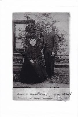
Photocopy of photograph of James and Ann Freeman of Tyendinaga Township, Ontario
Photocopy of a photograph of John Freeman (1836-1905) and his wife, Ann Naphan (1824-1923). At one time they owned the Arlington Hotel in Deseronto, Ontario.
Photocopy of photograph of No. 14 Platoon D Company No. 20 CIBTC-Ca, Brantford, Ontario
Photocopy of a group of men in Canadian Army basic training, including a Deseronto-based relative of the donor.

Digital copy of photograph of wedding of Stan McTaggart and Lalia Histed
Photograph of Stanley (Stan) McTaggart (1924-2007) and Lalia Histed (1921-2014) on their wedding day in November 1942 at their home on Dundas Street, Deseronto, Ontario. St. Mark's Anglican Church is visible in the background. Stan worked at Gibbard's in Napanee and later was a police officer in Deseronto for five years.
The individuals have been identified as:
Back row: Stan Sigsworth, Clarence Taylor, Stan Mastin, Elanora Histed, Mrs Robinson, ?, Mrs Mastin [?], ?
Front row: Katherine McTaggart, Herb Histed, Stan McTaggart, Lalia Histed, Blennet Histed, Annie ?, Pastor Leach.
Donated by Esther Wood, September 2015.

Digital copy of photograph of staff of Shannonville Canning Ltd.
Staff of Shannonville Canning Ltd., Shannonville, Ontario, in September 1938.
Names supplied:
Back row: Nellie Howard, Maggie Brant, Maggie Maracle, Mae Hill, Ethel Bardy, Georgina Rupert, Edna Maracle, Beatarice Brant, John Weese, ?, Mac FitzGerald, Lena FitzGerald, Edna Fuller, Harold Burtt, Mavis John, ?, Beatrice Smart, ?, Blanche Hill, Ivan Hill, Cora Maracle, Harold Elmy, Mr. Rightmyer, Tommy Howard and Percy "Diner" Howard
Second row: Marjorie FitzGerald, Dorsey Brant, Josie FitzGerald, Ethel John, Lydia Marion, Winnifred Maracle, Julia Maracle, Lydia Maracle, Kathleen Louis, Sadie Maracle, Gladys Brant, Eva Burtt, Anita Goodfellow, Stella Breadman, ?, Mrs Burtt, Winnie Howard and Marjorie Brant
Third row: Vincent Bardy, Madeline Spencer, ?, Pearl Brant, Leola Brant, Evelyn Noye, Muriel Hill, Alice Dow, Marjorie Elmy, Marion Hill, Reta Conley, Edna McCarthy, Helena Sager, Maggie Hill, Bertha Reed, Flossie ?, and Helen Fuller
Front row: Austin Fuller, Ross Brant, Clifford Hill, Eugene Maracle, Lorne Maracle, Harry Uens, ?, William Hill, ?, Carmon Spencer, Laural Burtt, Gerald Louis, Blake Cook and Roy Sager

Collage of photographs of members of the Town Council of Deseronto, Ontario
Photographs of members of the council of the Town of Deseronto:
George E. Clement
James Sexsmith
William Irvine
James Whitton
J. M. Olliver
George Parnham
A. A. Richardson, Deputy Reeve
Frederick S. Rathbun, Treasurer
Edward Wilkes Rathbun, Mayor
Robert Irvine, Clerk
James Dryden, Reeve
J. McCollough, Assessor
George Gonyou, Chief of Police
G. E. Deroche, Solicitor
T. D. Galt
William Mellow
James Saunders
Town of Deseronto

Photograph of couple by a barn
Photograph of a man, dog, and woman standing in a field in front of a barn.
Aerial Photograph of Tyendinaga Township
Part of Map collection
An aerial photograph of Tyendinaga Township, Map # TD19684Z01. The total area covered includes, Lots # 22-40, Concession 2, Lot # 22-31, Concession 3 - showing orthophoto right of way Selection Plan. For Ontario Hydro - Route & Site Selection Division. Aerial photo taken on September 10, 1973 and published August 25, 1976. Scale: 1 inch = 200 feet.
Aerial Photograph of Sophiasburgh Township
Part of Map collection
An aerial photograph of Sophiasburgh Township, Map # 1.71-4402- 2-144, (small section). The total area covered includes, Hwy 62 along the east side, Smith Road on west side, and in the centre Concession 7. A Provincial Government Aerial Photo. Dated 1971.
Aerial Photograph of Sophiasburgh Township
Part of Map collection
An aerial photograph of Sophiasburgh Township, Map # 1.71-4402- 2-144 (enlarged section). The total area covered includes, Consecon Creek and Marsh, Hwy 62, County Road 2 and west Concession 7 in centre of map. A “Little Swamp”, Provincial Government Aerial Photo. Scale 1:10,000. Dated 1971.
Aerial Photograph of Sophiasburgh Township
Part of Map collection
An aerial photograph of Sophiasburgh Township, Map # 1.71-4402- 2-144. The total area covered includes, Consecon Creek and Marsh, Hwy 62, County Road 2 and west Concession 7 in centre of map. A “Little Swamp”, Provincial Government Aerial Photo. Scale 1:10,000. Dated 1971.
Aerial Photograph of Haldimand, Percy & Cramahe Townships
Part of Map collection
An aerial photograph of Haldimand, Percy & Cramahe Townships, Map # 2056. The total area covered includes, Lots # 15 to 35, on Concession 4 to 10 in Cramahe Township, Lots # 3 to 16, on Concession 1 to 6, in Percy Township and Lots # 1 to 35, on Concession 1 to 10, in Haldimand Township, Northumberland County. An Ontario Hydro-Aerial Map, showing Hydro line and Trans Canada Pipe Lines. Circa 1975.
Aerial Photograph of Oshawa and Whitby
Part of Map collection
Oshawa & Whitby, Map # 2055 showing areas of; Oshawa & Whitby in Township of East Whitby and Township of Whitby, from Lake Ontario through the 8th Concession and Darlington Township. Then, from Lake to 8th Concession Lots # 30 to 35-showing Ontario Hydro Line, gas and oil pipelines. From Ontario Hydro. Dated 1972. Scale: 1 inch = 2000 feet.
Aerial Photograph of Bowmanville
Part of Map collection
Bowmanville, Map # 2054 showing areas of; Bowmanville and Darlington Township, Concession 1 to 10, Lots # 1 to 29, Showing Ontario Hydro Line, gas and oil pipelines and proposed Darlington Generating Station site. From Ontario Hydro. Dated 1972. Scale: 1 inch = 2000 feet.
Aerial Photograph of Port Hope
Part of Map collection
Port Hope, Map # TD16450Z00 (Mosaic 5 of 5) showing areas of; Hope Township from Lake Ontario to Concession 9, Hamilton Township and Lots # 30 to 35, Clarke Township Lots # 1 to 3, showing Hydro Lines and Pipelines. From Ontario Hydro. Dated December 21, 1972. Scale: 1 inch = 2000 feet.
Aerial Photograph of Clarke Township
Part of Map collection
Clarke Township, Map # TD16450Z00-Mosaic 2 of 4 showing areas of; Clarke Township from Lake Ontario to Concession 10, Hope Township and Lots # 20 to 35 showing Hydro Lines and Pipelines. From Ontario Hydro. Dated 1972.