Showing 41 results

Archival description
Madoc, Township of
Print preview Hierarchy View:

36 results with digital objects Show results with digital objects

Election Canada Districts in Centre Hastings

  • CA ON00156 M/M480-2646 - 2652 and 2654/2646
  • Item
  • 2003
  • Part of Map collection

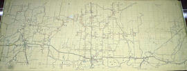
2 copies of maps detailing electoral districts #40 to 45 (inclusive) within Centre Hastings. The map includes polling divisions, road networks and municipal boundaries. Inset # 2, # 35073.

Canada. Department of Natural Resources

Map of Belleville to North of Bancroft

A map containing focused maps of: Trenton, Belleville, Prince Edward County, Frankford, Picton, Bancroft, Deseronto, Stirling, Tweed, Marmora and Madoc. Insets refer to roads, streets and highways. Published by Millhouse Maps in 2001.

MIllhouse Maps

Aerial Photograph of Madoc Township

  • CA ON00156 M/M470-2781 - 2794/2781
  • Item
  • c. 1977
  • Part of Map collection

Madoc Township, Map # A18256-148 showing areas of Hwy 62 at Bannockburn and the road east to Cooper. The railway parallel with Hwy 62. The Ontario Hydro easement running west from Cooper. By the Air Photographic Production Division of the Deptartment of Mines & Technical Surveys - Government of Canada.

Canada. Department of Mines and Technical Surveys

Aerial Photograph of Madoc Township

  • CA ON00156 M/M470-2781 - 2794/2782
  • Item
  • c. 1977
  • Part of Map collection

Madoc Township, north part Bannockburn with Hwy 62, the railway, and the Bannockburn Road running east toward Cooper. By the Air Photographic Production Division of the Deptartment of Mines & Technical Surveys - Government of Canada.

Canada. Department of Mines and Technical Surveys

Geological Map of the Madoc and Gananoque areas

2 maps showing geological areas in Madoc (Map No. 2053) and Gananoque (Map No. 2053). Scale 1 in to 2 miles. Booklet by D. F. Hewitt, Senior Geologist, Ontario Department of Mines, Toronto.

Ontario. Ministry of Natural Resources and Forestry

Hydro-Electric Power Commission of Ontario, Tweed-Section

  • CA ON00156 M/M430-2995 - 2996, 3018 - 3021, 3031/3018
  • Item
  • 16 Oct 1951
  • Part of Map collection

An original map produced for the Hydro-Electric Power Commission of Ontario, concerning hydro power lines, stations and transformers. However, the map also features railways, roads and land boundaries.

This map is the West Centre Section - Tweed ROA. The total area includes parts of Rawdon, Marmora, Huntingdon, Madoc, Hungerford, and Elzevir Townships. Dated October 16, 1951. Scale: 1.2 inches = 1 m.

Donated by David Pershik.

Madoc Township Map # 446773E

  • CA ON00156 M/M470-2591 - 2616/2615
  • Item
  • c. 1950
  • Part of Map collection

A reproduction of an air survey photograph produced by the Ontario Ministry of Natural Resources. Map #446773E of Madoc Township in Hastings County, Ontario. Circa 1950.

The photograph shows the northern part of Madoc Township, Bannockburn, Tudor Township, Concession 1 to 9, Robinson Lake, Westerly to Millbridge, Moira River, Highway 62, and the Canadian National Railway.

Donated by Walter I. Watson, P.L.S.

Ontario. Ministry of Natural Resources and Forestry

Madoc Township Map # 445772W

  • CA ON00156 M/M470-2591 - 2616/2609
  • Item
  • c. 1950
  • Part of Map collection

A reproduction of an air survey photograph produced by the Ontario Ministry of Natural Resources. Map #445772W of Madoc Township in Hastings County, Ontario. Circa 1950.

The photograph shows Madoc Township, Concession 5 to 9, Huntingdon Township Concession 14, northwest Elzevir Township, Queenboro and Black River.

Donated by Walter I. Watson, P.L.S.

Ontario. Ministry of Natural Resources and Forestry

Madoc Township Map # 445773E

  • CA ON00156 M/M470-2591 - 2616/2609
  • Item
  • c. 1950
  • Part of Map collection

A reproduction of an air survey photograph produced by the Ontario Ministry of Natural Resources. Map #445773E of Madoc Township in Hastings County, Ontario. Circa 1950.

The photograph shows Madoc Township, Concession 1 to 7, Hwy 62, and Moira River Watershed, Eldorado, Lake Township, Concession 3 to 10.

Donated by Walter I. Watson, P.L.S.

Ontario. Ministry of Natural Resources and Forestry

Minerals in northern Hastings County

A map of northern Hastings County detailing different types of mineral occurrences, see Legend. Published in 1943 by the Ontario Department of Mines. Scale: 1:120,000. The map includes parts of Quebec and USA, in relation to the region. It was produced to "accompany report by Jas E. Thomson in Vol. LII Ontario Department of Mines, Annual Report, 1943."

Donated by the Ontario Department of Mines, April 1, 1965.

Ontario. Department of Mines

Townships of Hastings County with advertisements

A map of Hastings County, in 1932, showing lakes, rivers, cities, towns and townships. A list of businesses within the county are on the right. Drawn exclusively for and published by Croydon Publishing Company.

Croydon Publishing Co.

South and Central Hastings Map

"Cummins Rural Directory Map:" A map of South and Central Hastings, in 1923, featuring post offices, hamlets and lot owners. Map is surrounded by advertisements. Published by Cummins Map Co., Toronto. Dimensions 71cm x 50.5cm.

Cummins Map Company

Lloyd's Map of Hastings County

A map of Hastings County outlining the twelve townships:
Marmora and Lake, Madoc, Tudor, Grimsthorpe, Elzevir; Rawdon, Huntingdon, Hungerford, Sidney, Thurlow, Tyendinaga. The northern townships are pictured on the right side.
As well as, the lots and concessions. Circa 1922. Scale: 1.5 miles: 1 inch. Published by Lloyd's Maps, Map Publisher.

Lloyd's Map, Map Publisher

Subdivision of part of east half of Lot 1 in the Township of Madoc

A certified reproduction of the "Subdivision of part of the east half of Lot # 1, Concession 6, Township of Madoc & partly in Village of Madoc, property of W. H. McBain.” Surveyed by Henry Carre O. L. S., and signed January 13, 1914.

This copy was made in 1972 of plan #454, as registered in the Hastings Land Registry Office.

Donated by Walter I. Watson, P. L. S.

Carre, Henry, O.L.S.

Map of Hastings with townships

A map of Hastings County outlining the twelve townships:
Marmora and Lake, Madoc, Tudor, Grimsthorpe, Elzevir; Rawdon, Huntingdon, Hungerford, Sidney, Thurlow, Tyendinaga.
As well as, the lots and concessions. Circa 1916.Scale: 4 miles: 1 inch.

Donated by K.G.M. Ross.

Map of the Counties of Hastings and Prince Edward

A "Map of the Counties of Hastings and Prince Edward." In 1898, the lots, concessions, churches, schools and mines are shown of the townships in Hastings and Prince Edward. Scale: 1.5 miles to an inch. Published by the Canadian Map Publishing Company in Hamilton, Ontario, for the Belleville Sun. Revised by Henry Carre, C.E. Inset is the map of North Hastings, scale 400 chains to an inch.

Carre, Henry, O.L.S.

Map of Hastings County in 4 sections

A map of Hastings County outlining townships from the Bay of Quinte in the south, to Wallaston, Limerick and Cashel in the north.
Map is in four sections. Scale: 3 miles : 1 inch. Original map is dated 1894. Photocopy from the Archives of Ontario.

Plan of Rectification Survey of Madoc Township

A certified reproduction of a “Plan showing the Rectification Survey... of the Township of Madoc.” The area contained includes; northern lots #30, 31, 32 on concessions 1-11 (inclusive) in Madoc Township. Originally surveyed by Charles Fraser Aylsworth, P. L. S. and produced on March 18, 1891.

This reproduction was made on June 5, 1972 and approved by the Deputy Registrar.

Donated by Walter I. Watson, P. L. S.

Aylsworth, Charles Fraser Sr., P.L.S.

Plan of Lakeview Cemetery in the Township of Madoc

A certified reproduction of the "Plan of Lake View Cemetery, situated on the west half of Lot # 1, Concession 7, Madoc Township.” Surveyed by C. Fraser Aylsworth Jr., P.L.S., and signed October 23, 1891.

This copy was made in 1972 of plan #287, as registered in the Hastings Land Registry Office.

Donated by Walter I. Watson, P. L. S.

Aylsworth, Charles Fraser Jr., O.L.S.

Plan of subdivision of Town Lot 2 in the Township of Madoc

A certified reproduction of the "Plan of subdivision into Town Lots - part of the south half of the east half of Lot # 2, Concession 5, Township Madoc - for June Whytock witnessed by David Whytock.” Surveyed by C. Fraser Aylsworth Jr., P.L.S., and signed April 3, 1889.

This copy was made in 1972 of plan #281, as registered in the Hastings Land Registry Office.

Donated by Walter I. Watson, P. L. S.

Aylsworth, Charles Fraser Jr., O.L.S.

Results 1 to 20 of 41