
Survey plans transferred from City of Belleville Engineering Department
- CA ON00156 2021-073
- Series
- 1974-1999
A series of 506 land registry survey plans for various parcels of land in Thurlow Township.
815 results with digital objects Show results with digital objects
Survey plans transferred from City of Belleville Engineering Department
A series of 506 land registry survey plans for various parcels of land in Thurlow Township.

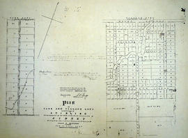
Plan of subdivision in Plainfield
Plan of subdivision creating Bay and Cross Streets in Plainfield, Thurlow Township, Ontario. Text reads: "Plan of Town lots laid out on the front of the East Half of lot number twenty three in the Seventh concession of the Township of Thurlow in the County of Hastings, Surveyed for the proprietor Josephy Fletcher Mackencie [Mackenzie] , By John Emerson P.L.S. October 1877. Scale one chain to an Inch. This plan is correct and is prepared under the provisions of the Registrations of Titles (Ontario) Act. John Emerson P.L.S. Duplicate Plan registered the first day of June A. D. 1878." The lot at the southeast corner is identified as "Halls Tavern Lot".
Emerson, John, P.L.S.

Digital photographs of Trenton fire insurance plans
Digital photographs of two fire insurance plans of Trenton, Ontario.
Chas. E. Goad Company

Map of Hastings County, Ontario
Map of Hastings County, Ontario, with business directory information for Belleville, Deseronto, Frankford, Madoc, Shannonville, Stirling and Tweed in the right and left-hand panels.
Croydon Publishing Company
Reproduction of 1931 fire insurance plan of Deseronto, Ontario
Photocopied sheets of the 1922 fire insurance plan with revision slips to October 1931.

Photocopy of plot plan of the Deseronto Cemetery
Plan of the Deseronto Cemetery, with plot numbers.
Town of Deseronto
Photocopy of plan of Rathbun farms near Deseronto, Ontario
Photocopy of a plan of the Rathbun Farms (later Fingland and Kimmett farms) on Boundary Road to the northeast of Deseronto, showing crop rotations and land use.

Map of Hastings and Prince Edward Counties
Part of Map collection
A map showing the roads, forts and inns of Hastings and Prince Edward Counties in 1850, by Major Baron DeRottenburg. The map extends from Brighton to Gananoque, Prince Edward County. and North to include Rawdon, Huntingdon, Hungerford Townships of Hastings County. Scale: 2 miles = 1". Dimensions 63cm x 44cm.
DeRottenburg, Major Baron

Map Hastings, Prince Edward, Northumberland and Peterborough Counties
Part of Map collection
A map of Hastings, Prince Edward, Northumberland and Peterborough counties in 1916 from the Department of Interior Canada. Published by J.E. Chalifour, Chief Geographer. Scale: 3" to 95 miles. Dimensions 63.5cm x 96.5cm.
The legend includes additional information about counties, towns, villages, boundaries, railways, canals, lots, concessions, portages, rapids and First Nations Territories.
Canada. Department of the Interior

Plan of village of Hastings in 1850
Part of Map collection
A certified reproduction of the "Plan of Village of Hastings on west half of Lot # 1 in 6th Concession of Township of Madoc for Uriah Seymour." Surveyed in May of 1850 by P. Elmore, P. L. S. A Furnace building and other buildings are depicted on a Common between the bridge and dam.
This copy was made in 1976 of plan #13, as registered in the Hastings Land Registry Office.
Donated by Walter I. Watson, O.L.S.
Elmore, Publius Virgillius, D.P.S.
Plan of Park and Village Lots in Stirling
Part of Map collection
A certified reproduction of the "Plan of Park and Village Lots in Village of Stirling. Being Lot # 23 in 9th Concession of Sidney Township for James Ross." Surveyed by John J. Haslett, P.L.S. in 1852.
This copy was made in 1972 of plan #16A, as registered in the Hastings Land Registry Office.
Donated by Walter I. Watson, O.L.S.
Haslett, John James, P.L.S. & D.P.S.
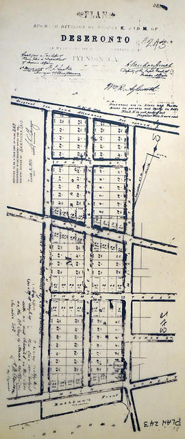
Plan of Blocks K and M in the town of Deseronto
Part of Map collection
A certified reproduction of the "Plan showing of Blocks K and M of Deseronto, on west plot of Lot 3, Concession A, Township of Tyendinaga.” Blocks K and M are from Main Street north to the original Concession Road Allowance, west to Brant Street, and east to Mill Street. Plan signed by William R. Aylsworth, P.L.S. and dated March 26, 1885.
This copy was made in 1972 of plan #243, as registered in the Hastings Land Registry Office.
Donated by Walter I. Watson, P. L. S.
Aylsworth, William Robert, O. L. S.
Teacher's Guide to Quinte in 1785
Part of Map collection
Map showing the Bay of Quinte to Presqu'ile to the eastern tip of Grande Isle (Wolfe Island) used as a teacher's guide to the area in 1785. The 20th century names are in capital letters as per the Legend.
Water Communication between the Bay of Quinte and Lake Huron
Part of Map collection
Map showing a measured sketch of the water communication between the Bay of Quinte and Lake Huron, May 1818. The total area extends from the Bay of Quinte and Lake Huron by Rice Lake to the falls of the River Trent to its mouth. A reproduction from the Archives of Canada.
Reproduction of Murray Canal Plan
Part of Map collection
"Murray Canal Plan Showing Portions of the Old Canal Reserve Which It is Proposed to Grant to the Province of Ontario."
A reproduction from an original at the Archives of Canada's map collection.

Map of Watersheds of the Moira and Napanee Rivers
Part of Map collection
A map of the Watersheds of the Moira and Napanee Rivers, 1950. From the Department of Planning and Development by A. H. Richardson, Chief Conservation Officer. Dimensions: 48cm x 35.5cm.
Richardson, A.H.

Map of Facilities within the Moira River Watershed
Part of Map collection
A map for recreation purposes, showing existing and proposed facilities in the Moira River watershed area. Not dated, circa 1950. Dimensions 47.5cm x 35cm.

Map of the Moira Region Watershed
Part of Map collection
A map of the Moira Region Watershed. Polychrome colours symbolize the varieties of soils and land use surveys, see Legend. Not dated, circa 1950. Published by the Ontario Department of Planning and Development, Conservation Branch. Dimensions 58.5cmx 69cm.
Ontario. Department of Planning and Development
Flood Risk Maps of the Lower Trent Region
Part of Map collection
7 flood risk maps for the Lower Trent Region. Part of the Canada-Ontario Flood Damage Reduction Program.
Ontario. Ministry of Natural Resources and Forestry
Canoe Routes in the Moira River Watershed
Part of Map collection
A double sided, folded map showing the location of canoe routes within the Moira River Watershed.
Moira River Conservation Authority