Showing 104 results

Archival description
Trenton With digital objects
Print preview Hierarchy View:

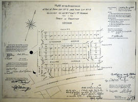
Subdivision of Park Lots 1-4 in the Town of Trenton

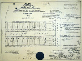
A certified reproduction of the "Subdivision of Park Lots # 1, 2, 3, & 4 being part of Lot # 1A in 1st Concession Township, for M. C. Francis.” Surveyed by J. N. Evans for Evans & Evans, C. E. & O. L. S. and signed May 13, 1913.

This copy was made in 1972 of plan #440, as registered in the Hastings Land Registry Office.

Donated by Walter I. Watson, P. L. S.

Evans and Co., Engineers and Surveyors

Subdivision of Park Lots 16 in the town of Trenton

A certified reproduction of the "Subdivision of Park Lot # 16, Reg. Plan 232, being part of Lot # 1 A, Concession 1, Township of Murray, now Trenton.” The area surveyed includes; Park Lot # 16, both sides of Edward Street and west of Sidney Street. Surveyed by John H. Shaw, O. L. S. and signed July 24, 1917.

This copy was made in 1972 of plan #490, as registered in the Hastings Land Registry Office.

Donated by Walter I. Watson, P. L. S.

Shaw, John Henry, O.L.S.

Subdivision of Park Lots 61-62 in the town of Trenton

A certified reproduction of the "Subdivision of Park Lots # 61-62, part of Lot # 63, Reg. Plan 240 by Evans & Bolger P. L. S. being part of Township Lot A, Concession 1, Sidney Township (now Trenton).” The area surveyed includes; east of Sidney Street, including both sides of Edward Street, both sides of Charles Street, and east to the boundary of Park Lots # 61, 62, and 63. Surveyed by John H. Shaw, O. L. S. and signed October 1, 1918.

This copy was made in 1972 of plan #492, as registered in the Hastings Land Registry Office.

Donated by Walter I. Watson, P. L. S.

Shaw, John Henry, O.L.S.

Subdivision of part Lots 11-12 in the town of Trenton

A certified reproduction of the "Subdivision [of] Part Lots # 11 and 12, east side of Byron Street, formerly Trenton Street. Reg. Plan No. 112, Town of Trenton.” The total area surveyed includes; the east side of Byron Street (formerly Trenton Street), east to Station Street (not open) and both sides of Weeks Avenue. Surveyed by John T. Ransom, O. L. S. and signed September 22, 1948.

This copy was made in 1972 of plan #824, as registered in the Hastings Land Registry Office.

Donated by Walter I. Watson, P. L. S.

Ransom, John Thomas, P.L.S.

Subdivision of part of Block E in the Town of Trenton

A certified reproduction of the "Subdivision of Part of Block E on Evans & Bolger Plan of Trenton for Hugh Leonard O'Rourke and J. W. Crews.” Surveyed by Evans & Evans, Civil Engineers & O. L. S. and signed July 7, 1913.

This copy was made in 1972 of plan #445, as registered in the Hastings Land Registry Office.

Donated by Walter I. Watson, P. L. S.

Evans and Co., Engineers and Surveyors

Subdivision of part of Lot 3 in the Town of Trenton

A certified reproduction of the "Subdivision of part of the west half of Lot # 3, Concession A, in Murray Township, Northumberland County. Block P and part of Block Q according to Evans & Bolger Plan." The area includes; north of Town Park to Dundas Street and west of Film Street. Surveyed by Leighton A. van Skiver, O. L. S. and signed July 1947.

Donated by Walter I. Watson, P. L. S.

van Skiver, Leighton Adelbert, O.L.S. & D.L.S.

Subdivision of part of west half of Lot 3 in the Town of Trenton

A certified reproduction of the "Subdivision of part of the west half of Lot # 3, Concession 1, Township of Murray in Trenton, for Jesse Funnell.” Surveyed by John D. Evans of Evans & Evans, C. E. & O. L. S. and signed May 7, 1913.

This copy was made in 1972 of plan #441, as registered in the Hastings Land Registry Office.

Donated by Walter I. Watson, P. L. S.

Evans and Co., Engineers and Surveyors

Subdivision of part Park Lot 3 in the Town of Trenton

A certified reproduction of the "Subdivision of part of Park Lot # 3, east of Ontario Street, on Plan of Meyer's Park Lots in Trenton.” Surveyed by John D. Evans O. L. S. and signed June 18, 1917.

This copy was made in 1972 of plan #488, as registered in the Hastings Land Registry Office.

Donated by Walter I. Watson, P. L. S.

Evans, John Dunlop, P.L.S.

Subdivision of Sidney Heights in the Town of Trenton

A certified reproduction of the "Sidney Heights subdivision of Part of Park Lots # 16 & 17 - west side of Byron Street, Trenton.” Surveyed by John D. Evans O. L. S. and signed May 15, 1912.

This copy was made in 1972 of plan #419, as registered in the Hastings Land Registry Office.

Donated by Walter I. Watson, P. L. S.

Evans, John Dunlop, P.L.S.

Subdivision of the Hawley Estate in the Township of Murray

A certified reproduction of the "Hawley Estate, subdivision being part of Lot # 1 in 1st Concession of Murray Township.” Surveyed by Archibald W. Ponton, P.L.S., and signed September 26, 1882.

This copy was made in 1972 of plan #229, as registered in the Hastings Land Registry Office.

Donated by Walter I. Watson, P. L. S.

Ponton, Archibald William, P.L.S. & D.L.S.

Subdivision of the part of Park Lot 2, 5 in the Town of Trenton

A certified reproduction of the "Subdivision of Part of Park Lot # 2 and Park Lot # 5, as laid out on Lot 1A, Concession 1, Township of Murray for Charles MacLellan.” Surveyed by John D. Evans O. L. S. and signed July 20, 1917.

This copy was made in 1972 of plan #478, as registered in the Hastings Land Registry Office.

Donated by Walter I. Watson, P. L. S.

Evans, John Dunlop, P.L.S.

Topographical map of east Trenton - Canada sheet

A topographical map of Trenton - Canada sheet 31 C/4. Map was published by the Department of National Defence in December 1962.
This second edition was converted from the first edition of the 1:63,360 map to 1:50,000 by the A. S. E. in 1950.

Insets include:
1) legend
2) index to adjoining sheets
3) mean declination
4) grid reference on the sheet and other minor information.

Army Survey Establishment

Topographical map of Trenton - Canada sheet

  • CA ON00156 M/M470-1559 - 1573, 1576 - 1579, and 1585 - 1621/1615
  • Item
  • 1938
  • Part of Map collection

A topographical map of Trenton - Canada sheet #31 C/4. Published by the Army Survey Establishment, Department of National Defence in 1938. Scale one inch to one mile - 1/63, 360.

Donated by Gerry Boyce.

Canada. Department of National Defence

Topographical Map of west Trenton - Canada sheet

A topographical map of west Trenton - Canada sheet #31 C/4. Area includes the West Half of Trenton and part of Northumberland County. Map was published by the Department of National Defence in December 1962. Scale 1:50,000.

Canada. Department of National Defence

Town of Trenton with advertising businesses

A photocopy of a map of the Town of Trenton, circa 1915. The map features advertisements for local businesses, important sites, industries and many railways and stations.

Donated by Bruce Polmanter.

Trenton Electric & Water Co. Limited in Sidney Township

  • CA ON00156 M/M430-2998 - 3001/M430-3001
  • Item
  • c. 1910
  • Part of Map collection

An original map produced for the Trenton Electric & Water Co. Limited, concerning proposed transmission lines within the Township of Sidney. However, the map also features railways, roads and land boundaries. Circa 1910. Scale: 50 chains = 1 inch. Map composed by Smith, Kerry and Chace Engineers located in Toronto, Winnipeg, Calgary and Vancouver.

Donated by David Pershick.

Smith, Kerry and Chace Engineers

Trenton Electric & Water Co. Limited in Thurlow and Sidney Townships

  • CA ON00156 M/M430-2998 - 3001/M430-2999
  • Item
  • 31 Mar 1910
  • Part of Map collection

An original map produced for the Trenton Electric & Water Co. Limited, concerning proposed transmission lines within the Townships of Thurlow and Sidney. However, the map also features railways, roads, mills and land boundaries. Dated March 31, 1910. Scale: 1/4 mile = 1 inch. Map composed by Smith, Kerry and Chace Engineers located in Toronto, Winnipeg, Calgary and Vancouver.

The map includes the first 4 concessions, Lots 33-38 in Sidney Township and Lots 1-13 in Thurlow Township.

Donated by David Pershick.

Smith, Kerry and Chace Engineers

Trenton Electric & Water Co. Limited in Thurlow Township

  • CA ON00156 M/M430-2998 - 3001/M430-2998
  • Item
  • c. 1910
  • Part of Map collection

An original map produced for the Trenton Electric & Water Co. Limited, concerning their water mains, towers and substations within the Township of Thurlow. However, the map also features railways, roads and land boundaries. Circa 1910. Scale: 50 chains = 1 inch. Map composed by Smith, Kerry and Chace Engineers located in Toronto, Winnipeg, Calgary and Vancouver.

Donated by David Pershick.

Smith, Kerry and Chace Engineers

Results 81 to 100 of 104