Hastings County Roads from Midland District Court.
- CA ON00156 TR/1426-1
- File
- [?]
File contains documents regarding roads in Thurlow and Midland, included in the documents are small maps and diagrams.
7 results with digital objects Show results with digital objects
Hastings County Roads from Midland District Court.
File contains documents regarding roads in Thurlow and Midland, included in the documents are small maps and diagrams.
Hastings Council Roads & Bridges 1862
File contains petitions to the council regarding road repair in Thurlow and Tyendinaga, as well as a special committee report about road and bridge repair and financial information about the cost of repairing various roads.
Thurlow Township : Fairfield Bridge, 1967
File contains a newspaper clipping concerning the replacement of Fairfield's Bridge, on the Moira River, with a new concrete structure.

Townships of Hastings County with advertisements
Part of Map collection
A map of Hastings County, in 1932, showing lakes, rivers, cities, towns and townships. A list of businesses within the county are on the right. Drawn exclusively for and published by Croydon Publishing Company.
Croydon Publishing Co.
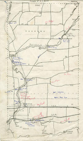
Map of Thurlow Township with annotations
Part of Map collection
A map of Thurlow Township featuring the addition of handwritten annotations. Concessions, railways, proprietors, businesses and locations are featured. The map extends from the Bay of Quinte in the southwest to Roslin the northeast. Circa 1950 (Bakelite plant opened c. 1948 and the Foxboro Cheese Factory closed in 1961).
Specific annotations are as follows: Halloway Grist Mill, Latta Bridge, Plainfield Grist, Saw Mill, O'Brien's Bridge, Grist Mill, Canning Factory Foxboro, Footbridge, Cheese Factory, Fairfields Bridge, Dam Corbyville, Distillery, Cannifton Dam, Grist & Saw Mill, Quarry & Substation, Round House, Brickyard, Graham's Dried Foods, Bell Telephone Lines, Hydro Power Lines, and Cement Works.
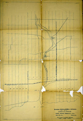
Alternative Hydro Routes from Lennox to Oshawa
Part of Map collection
A map studying alternative routes for hydroelectric power. The area covers from West Oshawa, East Mount Pleasant Jct. North Rice Lake & South Lake Ontario.
Commonwealth Associates Inc.
Map 3 from the Hydro Comission Route Inquiry
Part of Map collection
A map studying the proposed routes for power transmission from Lennox to Oshawa. The area covers from West Oshawa, East Mount Pleasant Jct. North Rice Lake & South Lake Ontario.
Solandt Commission Inquiry

Trenton Electric & Water Co. Limited in Thurlow Township
Part of Map collection
An original map produced for the Trenton Electric & Water Co. Limited, concerning their water mains, towers and substations within the Township of Thurlow. However, the map also features railways, roads and land boundaries. Circa 1910. Scale: 50 chains = 1 inch. Map composed by Smith, Kerry and Chace Engineers located in Toronto, Winnipeg, Calgary and Vancouver.
Donated by David Pershick.
Smith, Kerry and Chace Engineers
Trenton Electric & Water Co. Limited in Thurlow and Sidney Townships
Part of Map collection
An original map produced for the Trenton Electric & Water Co. Limited, concerning proposed transmission lines within the Townships of Thurlow and Sidney. However, the map also features railways, roads, mills and land boundaries. Dated March 31, 1910. Scale: 1/4 mile = 1 inch. Map composed by Smith, Kerry and Chace Engineers located in Toronto, Winnipeg, Calgary and Vancouver.
The map includes the first 4 concessions, Lots 33-38 in Sidney Township and Lots 1-13 in Thurlow Township.
Donated by David Pershick.
Smith, Kerry and Chace Engineers

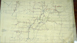
Hydro-Electric Power Commission of Ontario, Frankford Section
Part of Map collection
An original map produced for the Hydro-Electric Power Commission of Ontario, concerning hydro power lines, stations and transformers. However, the map also features railways, roads and land boundaries.
This map is of the North Section - Frankford Rural Power District. The total area includes parts of Thurlow, Huntingdon, Sidney, Rawdon, Campbellford, Seymour, Brighton, and Percy Townships. Circa 1950.
Donated by David Pershik.
Hydro-Electric Power Commission of Ontario, Tweed Section
Part of Map collection
An original map produced for the Hydro-Electric Power Commission of Ontario, concerning hydro power lines, stations and transformers. However, the map also features railways, roads and land boundaries.
This map is of the Southwest Section - Tweed Rural Power District. The total area includes parts of Hungerford, Huntingdon, and Thurlow Townships. Dated October 16, 1951. Scale: 2 inches = 1 mile.
Donated by David Pershik.
Ontario Hydro Aerial Photograph of Thurlow Township
Part of Map collection
An aerial photograph of Thurlow Township, Concession 4 (Map # TD19686Z). The photo includes Lots # 12 to 31, including proposed Hydro right of way and land owner's names and instrument numbers. Photographed on September 10, 1973 and annotations made July 27, 1976. Scale 1 inch = 200 feet.
For the Ontario Hydro Route and site Selection Division, Orthophoto R/W Selection Plan Lennox G. S. - Oshawa Area T. S. Aerial View.
By J. E. Clements- photogrammetric production officer; D. Crozier- chief draftsman; J. Sedgwal- project engineer; C. E. Bishop- Sr R/W planning engineer.
Ontario Hydro
Ontario Hydro Aerial Photograph of Thurlow Township
Part of Map collection
An aerial photograph of Thurlow Township, Concession 4 (Map # TD19687Z). The photo includes Concession 4, part of Concession 5, Lot # 1 to 12, including proposed Hydro right of way and land owners names and instrument numbers. Photographed on September 10, 1973 and annotations made July 27, 1976. Scale 1 inch = 200 feet.
For the Ontario Hydro Route and site Selection Division, Orthophoto R/W Selection Plan Lennox G. S. - Oshawa Area T. S. Aerial View.
By J. E. Clements- photogrammetric production officer; D. Crozier- chief draftsman; J. Sedgwal- project engineer; C. E. Bishop- Sr R/W planning engineer.
Ontario Hydro
Ontario Hydro Aerial Photographs of Lennox to Oshawa Area
Part of Map collection
5 aerial photographs of Thurlow, Tyendinaga and Thurlow Townships, in Hastings County, Ontario.
Photographed on September 10, 1973 and annotations made July 27, 1976. Scale 1 inch = 200 feet.
For the Ontario Hydro Route and site Selection Division, Orthophoto R/W Selection Plan Lennox G. S. - Oshawa Area T. S. Aerial View.
By J. E. Clements- photogrammetric production officer; D. Crozier- chief draftsman; J. Sedgwal- project engineer; C. E. Bishop- Sr R/W planning engineer.
Ontario Hydro
Ontario Hydro Plan of Lots 25-31 in Thurlow Township
Part of Map collection
Plan showing Thurlow Township, Parts of Lots # 25 to 31, Concession 4, and the Ontario Hydro proposed right of way (Map # TD30193Z). For Ontario Hydro, Design and Construction Branch, Surveys and Mapping. Scale 1 inch = 200 feet. Drawn by R. Sweeney, R. A. Schan, O .L. S.
Ontario Hydro
Ontario Hydro Plan of Lots 18-24 in Thurlow Township
Part of Map collection
Plan showing Thurlow Township, Parts of Lots # 18 to 24, concession 4, Ontario Hydro proposed right of way (Map # TD30194Z). For Ontario Hydro, Design and Construction Branch, Surveys and Mapping. Scale 1 inch = 200 feet. Drawn by R. Sweeney, R. A. Schan, O .L. S.
Ontario Hydro
Ontario Hydro Plan of Lots 9-18 in Thurlow Township
Part of Map collection
Plan showing Thurlow Township, Parts of Lots # 9 -18, Concession 4, and the Ontario Hydro proposed right of way. (Map # TD30195Z). For Ontario Hydro, Design and Construction Branch, Surveys and Mapping. Scale 1 inch = 200 feet. Drawn by R. Sweeney, R. A. Schan, O .L. S.
Ontario Hydro
Ontario Hydro Plan of Lots 2-8 in Thurlow Township
Part of Map collection
Plan showing Thurlow Township, Parts of Lots # 2 -8, Concession 4, Ontario Hydro proposed right of way (Map # TD30196Z). For Ontario Hydro, Design and Construction Branch, Surveys and Mapping. Scale 1 inch = 200 feet. Drawn by R. Sweeney, R. A. Schan, O .L. S.
Ontario Hydro
Ontario Hydro Aerial Plan of Lots 25-31 in Thurlow Township
Part of Map collection
Plan showing Thurlow Township, Parts of Lots # 25 to 31, Concession 4, Ontario Hydro proposed right of way (Map # TD30193Z). For Ontario Hydro, Route and Site Selection Division. Scale: 1 inch = 200 feet. Drawn by R. Sweeney 1977, R. A. Schan, O. L. S.
Ontario Hydro
Reproduced plan of Thurlow Railway Company Location
Part of Map collection
A photocopy of the "Thurlow Railway Company Location Plan Profile & Book of Reference, Province of Ontario." The area included extends from Lehigh Portland Cement Co. in Point Ann, First Concession of Thurlow Township and Lot # 23.
Buiy, Rayman R.