Mostrando 195 resultados

Descripción archivística
Natural resources
Imprimir vista previa Hierarchy Ver :

34 resultados con objetos digitales Muestra los resultados con objetos digitales

Plan of Gatling Co.'s Gold Mining Property and adjoining lots in Marmora

  • CA ON00156 M/M440-1443
  • Unidad documental simple
  • c. 1880
  • Parte deMap collection

"Plan of Gatling Co.'s Gold Mining Property and adjoining lots, Marmora, County of Hastings, Ontario." Scale: 1:3000. Published by The Desbarats Lith. and Comp. Montreal.

Donated by the Col. W. N. Ponton Estate. Col. Ponton or a relation presumably made the additional pen-written notes on the map.

Gatling Company owned the Gatling and Tuttle shafts at the Delora Mine, which were first opened by the Gatling Gold and Silver Mining company in 1873.
Read more: http://www.marmorahistory.ca/1866-founding-of-deloro

Sin título

Map of Mineral Deposits in Marmora

  • CA ON00156 M/M430-2645
  • Unidad documental simple
  • c. 1880
  • Parte deMap collection

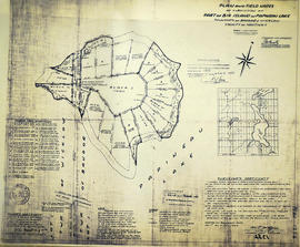
An original, coloured plan of mineral deposits in "Marmora - Scale half mile to an inch." The plan includes Lots 1-20 on Concessions 6-11 in Marmora Township.

The types of mineral deposits include ranges of silurian limestone, metamorphic rocks, a gold bearing belt, and a range of reddish syenites. Mining companies include Hawkeye Co. Mine, Gatling Mining Co., Taule Mine, Severn Mine, McKinnon Mine and the Canada Consolidated Gold Mining Company. Also featured is the settlement of Malone, several roads, lakes and the Central Ontario Railway.

Subdivision of Lot 1 in the Township of Wicklow

  • CA ON00156 M/M430-2318
  • Unidad documental simple
  • 1 Dec 1960
  • Parte deMap collection

A certified reproduction of the "Subdivision of Lot # 1, Concession 10 & 11, Township of Wicklow, for Dept. Lands & Forests.” The area includes; Lots # 1 to 5 and Block 'A' on the northeast shore of Papineau Lake in Wicklow Township. Surveyed by Michael J. McAlpine, O. L. S. and signed December 1, 1960.

Donated by Walter I. Watson, P. L. S.

Sin título

Subdivision of part of Lot 3 in the Township of Wicklow

  • CA ON00156 M/M430-2317
  • Unidad documental simple
  • 1 Dec 1960
  • Parte deMap collection

A certified reproduction of the "Subdivision of part of Lot # 3, Concession 10, Township of Wicklow, prepared for Dept. of Lands & Forests.” The area includes; Lots # 1 to 12, Blocks A to D on the northwest shore of Papineau Lake. Surveyed by Michael J. McAlpine, O. L. S. and signed December 1, 1960.

Donated by Walter I. Watson, P. L. S.

Sin título

Subdivision of part of Big Island on Papineau Lake

  • CA ON00156 M/M430-2316
  • Unidad documental simple
  • 1 Dec 1960
  • Parte deMap collection

A certified reproduction of the "Subdivision of part of Big Island in Papineau Lake, Township of Bangor & Wicklow - for Dept. Lands & Forests.” The area includes; Big Island in Papineau Lake, Lots # 1-8 and Blocks P-I in the Township of Bangor & Wicklow. Surveyed by John Thomas Ransom, O. L. S. and signed December 1, 1960.

Donated by Walter I. Watson, P. L. S.

Sin título

Geological Map of the Madoc and Gananoque areas

  • CA ON00156 M/M430-1156-1157
  • Unidad documental simple
  • 1974
  • Parte deMap collection

2 maps showing geological areas in Madoc (Map No. 2053) and Gananoque (Map No. 2053). Scale 1 in to 2 miles. Booklet by D. F. Hewitt, Senior Geologist, Ontario Department of Mines, Toronto.

Sin título

Map by the Bancroft Mineral Society

  • CA ON00156 M/M430-1150
  • Unidad documental simple
  • c. 1965
  • Parte deMap collection

A map of the highways, gravel roads, towns and mineral deposits located in the town of Bancroft and the surrounding area. Published by the Bancroft and District Chamber of Commerce. On the reverse side is the key to the numbered mineral deposits - types of minerals and the exact location/owner.

Sin título

Restoring Water Quality in the Bay of Quinte

  • CA ON00156 M/M410-1063
  • Unidad documental simple
  • c. 1980
  • Parte deMap collection

A double sided, folded map discussing pollution sources in the Bay of Quinte - where they are located, how they were created and how to clean up the pollutants.

Minerals of Ontario

  • CA ON00156 M/M400-1033
  • Unidad documental simple
  • c. 1972
  • Parte deMap collection

A double sided, folded map showing the location and types of mineral in Ontario. The back side shows photographs of each type of mineral. Published by the Ministry of Industry & Tourism and Ministry of Natural Resources.

Sin título

Map of Ontario Geology and Principal Minerals

  • CA ON00156 M/M400-1024
  • Unidad documental simple
  • 1970
  • Parte deMap collection

A double-sided map of Ontario Geology and Principal Minerals. The inside discusses information, research and statistics of minerals found in Ontario. The map shows where the minerals are found in Ontario. Published by the Ontario Dept. of Mines and Northern Affairs in 1970.

Sin título

Geological Map of the Province of Ontario

  • CA ON00156 M/M400-1020
  • Unidad documental simple
  • 1958
  • Parte deMap collection

A Geological Map of the Province of Ontario published by the Ontario Department of Mines in 1958. Geology compiled by J. Satterly from published and unpublished maps of the Ontario Department of Mines, the Geological Survey of Canada, mining companies & technical publications (as per Legend). Scale 1 inch to 20 miles.

Sin título

Marlbank

File contains two newspaper articles from the Napanee Beaver about the Marlbank Cement Company. founded when the Rathbun Lumber Co. built a cement plant and company town at the site of the present day village of Marlbank. The Marlbank plant was an early victim of downsizing. The ruins outside the town remain just as they were left almost 100 years ago.

Booklet "Over the Hills of Hastings"

This file contains a booklet titled "Over the Hills of Hastings" published in 1923 with the intent to bring attention to the advantages of Hastings County. It contains a brief history of the county, also featuring natural resources in the area, a description of the townships within the county and of Belleville and includes a map of Hasting County .

Resultados 1 a 20 de 195