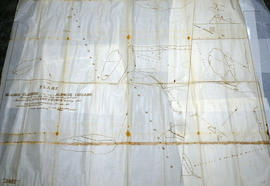
An original, waxed linen map entitled "Islands claimed by Alnwick Indians, Pursuant to Instructions bearing date Crown Lands, Dept. Quebec 2nd October 1861." The area in mention concerns the Huyck Bay Islands, Lake Ontario, and Pleasant Bay. Surveyed by Duncan McDonell Greenfield and John McNaughton, P. L. S. in May, June, July and August, 1862. Scale: 8 chains to an inch.
Map showing counties, townships, concessions and lots in the Districts of Prince Edward and Midland. Surveyed by Publius Virgillius Elmore, D.L.S. Published by Hallowell U.C. Dated 1836. Scale 160 chains : 1". Map copied from the Archives of Ontario.
Map showing townships in the District of Prince Edward County: South Murray, Sidney, Thurlow, Ameliasburgh, Sophiasburgh. See boundary lines on map. Surveyed by Publius Virgillius Elmore, D.L.S. Dated 1835. Map copied from the Archives of Ontario.
An original, waxed linen map entitled "Islands claimed by Alnwick Indians, Pursuant to Instructions bearing date Crown Lands, Dept. Quebec 2nd October 1861." The area in mention concerns the West Lake Islands, in Prince Edward County. Surveyed by Duncan McDonell Greenfield and John McNaughton, P. L. S. in May and June 1862. Scale: 8 chains to an inch.
An original, waxed linen map entitled "Plans of Islands claimed by the band of Alnwick Indians. Pursuant to Instructions bearing date “Crown Lands Department” Quebec 2nd October 1861." The area in mention concerns Weller's Bay and Hay Bay, in Prince Edward County. Surveyed by John McNaughton, P. L. S. in April and May 1862. Scale: 8 chains to an inch.