An 1877 map of Belleville, Hastings County, Ontario by Evans & Bolger, surveyors. Map includes a table showing dates of plans in the registry office with plan name, wards and dates.
A map showing a plan of survey for lots 4, 5, 6, 7, 8, 9 and lots 37, 38, 39, 40 on the south side of Bridge Street East between Dufferin and Macdonald Avenues in Belleville, Ontario. Surveyed by John T. Ransom on March 1, 1951 and amended April 14, 1960. Scale: 1'':50'.
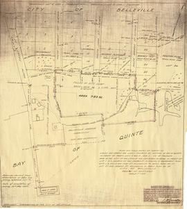
A map showing a plan for the Belleville Harbour. The total area stretches from south Front Street to the Ponton Plan. Published by John T. Ransom on May 19th, 1947. The map features field notes of survey of lands, marshes and Bay of Quinte waters. Scale: 1':100'.
A reproduction of an air survey photograph produced by the Ontario Ministry of Natural Resources. Map # 443772E of Thurlow Township in Hastings County, Ontario. Circa 1950.
The photograph shows the east part of Thurlow Township and west part of Tyendinaga Township from Concession 5 to Concession 8.
Donated by Walter I. Watson, P. L. S.
Ontario. Ministry of Natural Resources and Forestry
Map showing townships in the District of Prince Edward County: South Murray, Sidney, Thurlow, Ameliasburgh, Sophiasburgh. See boundary lines on map. Surveyed by Publius Virgillius Elmore, D.L.S. Dated 1835. Map copied from the Archives of Ontario.
A map of a tract of land known as Lot # 4 in the 1st and 2nd Concessions of the Township of Thurlow in the Midland District of Upper Canada. Part of 428 acres purchased from Mississauga First Nations peoples. The total area was East and West of Moira River extending to the Bay of Quinte. By Grant, Surveyor General's Office York and Jos. Ridout, Surveyor General on September 6th, 1811. Scale: 20 chains to an inch.
A map showing a plan and additional field notes about water lots in the mouth of the Moira River and Bay of Quinte. The total area stretches from the mouth of the Moira River to south Front Street to Mary Street. Published by Thomas S. Ransom on July 31, 1961. The map was used for the installation of sewer lines. Scale: 1':100'.