Belleville Transit Rider Guide and Schedule 2015
- CA ON00156 M/M440/1823
- Unidad documental simple
- 2015
Parte deMap collection
A map featuring the transit routes, street routes and rider fares for the Belleville Bus Transit system.
Sin título
14 resultados con objetos digitales Muestra los resultados con objetos digitales
Belleville Transit Rider Guide and Schedule 2015
Parte deMap collection
A map featuring the transit routes, street routes and rider fares for the Belleville Bus Transit system.
Sin título
Belleville Transit Rider Guide and Schedule 1979
Parte deMap collection
A map featuring the transit routes, street routes and rider fares for the Belleville Bus Transit system.
Sin título
Belleville Transit Rider Guide and Schedule 2018
Parte deMap collection
A map featuring the transit routes, street routes and rider fares for the Belleville Bus Transit system.
Sin título
Belleville Transit Rider Guide and Schedule 2017
Parte deMap collection
A map featuring the transit routes, street routes and rider fares for the Belleville Bus Transit system.
Sin título
Belleville Transit Rider Guide and Schedule 2016
Parte deMap collection
A map featuring the transit routes, street routes and rider fares for the Belleville Bus Transit system.
Sin título
Belleville Transit Rider Guide and Schedule 2010
Parte deMap collection
A map featuring the transit routes, street routes and rider fares for the Belleville Bus Transit system.
Sin título

South and Central Hastings Map
Parte deMap collection
"Cummins Rural Directory Map:" A map of South and Central Hastings, in 1923, featuring post offices, hamlets and lot owners. Map is surrounded by advertisements. Published by Cummins Map Co., Toronto. Dimensions 71cm x 50.5cm.
Sin título

Parte deMap collection
A map showing concessions and lots of Huntingdon - Madoc Township, Hastings County. Circa 1869. 30 advertisements for companies surround the map. Published by Macleod and Carre, Engineers and Surveyors. Scale: 1:63,000. Dimensions: 34.0cm x 37.0cm. Map was created from Government plan.
Donated from the Col. W. N. Ponton Estate. Penciled notes on map show Ponton family's interest in mining, especially after the Eldorado Gold Rush in 1866.
Sin título
Sketch of future Belleville waterfront
Parte deMap collection
A "Surveyor's Concept Plan of Belleville Waterfront in the future." Drawn by Paul Wiegand circa 1970.
Includes heritage buildings moved to new location. Heritage buildings (left to right) Lynch House, [unknown] Patrie House, Margaret Simpson Inn (1820) [church], [house from Pinnacle or Church St.?] . . . 2nd from right: McIntosh, Ridley House, right: [unknown]; in foreground: Petrie Stone building. P. Wreg and Concept of Belleville Harbour.
Sin título

Map of the Counties of Hastings and Prince Edward
Parte deMap collection
A "Map of the Counties of Hastings and Prince Edward." In 1898, the lots, concessions, churches, schools and mines are shown of the townships in Hastings and Prince Edward. Scale: 1.5 miles to an inch. Published by the Canadian Map Publishing Company in Hamilton, Ontario, for the Belleville Sun. Revised by Henry Carre, C.E. Inset is the map of North Hastings, scale 400 chains to an inch.
Sin título
Belleville Transit Rider Guide and Schedule c. 1995
Parte deMap collection
A map featuring the transit routes, street routes and rider fares for the Belleville Bus Transit system.
Sin título
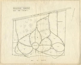
Map of the Belleville Cemetery
Parte deMap collection
A map of the Belleville Cemetery grounds, before 1952. Scale: 100 feet : 1 inch.
Belleville Transit Rider Guide and Schedule 1981
Parte deMap collection
A map featuring the transit routes, street routes and rider fares for the Belleville Bus Transit system.
Sin título
Belleville Transit Rider Guide and Schedule 2012
Parte deMap collection
A map featuring the transit routes, street routes and rider fares for the Belleville Bus Transit system.
Sin título

Parte deMap collection
A map of Prince Edward County featuring information about local historical traditions, agriculture, community life and geography. Published in 1937 through Picton Times by Conger Allison. Dimensions: 72cm x 53cm.
Sin título

School Section Boundaries in Thurlow Township
Parte deMap collection
A map of the boundaries of school sections in Thurlow Township, December 1859. The sections are colourized polychrome. Concessions and main bodies of water are marked. By John Emerson, P.L.S. Dimensions 22.0cm x 35.0cm.
Donated by Albert Stapley in Belleville, July 1962.
Sin título
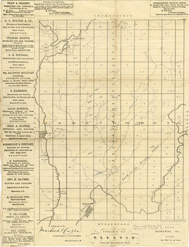
Parte deMap collection
A map showing concessions and lots of Elzevir Township, Hastings County. Circa 1869. 16 advertisements are present on the left-hand side. Published by Macleod and Carre, Engineers and Surveyors. Scale: 1:63,000. Dimensions: 29.0cm x 37.5cm.
Sin título

Parte deMap collection
A map showing concessions and lots of Cashel Township, Hastings County. Circa 1869. 13 advertisements for companies are present on the left-hand side. Published by Macleod and Carre, Engineers and Surveyors. Scale: 1:63,000. Dimensions: 29.0cm x 33cm. Map was created from Government plan.
Donated from the Col. W. N. Ponton Estate. Penciled notes on map show Ponton family's interest in mining, especially after the Eldorado Gold Rush in 1866.
Sin título

City of Belleville and Advertisements
Parte deMap collection
A hand-drawn map of Belleville, Ontario in 1950. The map itself features street names and major water ways. Advertisements surround the map. Published by S. A. Renouf Advertising Co. and drawn by F. P. Lloyd. Scale 1:15,000.
Sin título

Parte deMap collection
Map showing concessions, traveled roads and lots of Marmora Township, Hastings County. Areas of gold mines are also charted. Scale: 1 mile : 1 inch. Published by MacLeod & Carre Engineers and Surveyors in Belleville, Ontario (Canada West). Local advertisements surround map.
Received from the Public Archives of Canada on 3 May 1971.
Sin título