Belleville Transit Rider Guide and Schedule 1979
- CA ON00156 M/M440/M440-1827
- Item
- Mar 1979
Part of Map collection
A map featuring the transit routes, street routes and rider fares for the Belleville Bus Transit system.
Belleville Transit Commission
14 results with digital objects Show results with digital objects
Belleville Transit Rider Guide and Schedule 1979
Part of Map collection
A map featuring the transit routes, street routes and rider fares for the Belleville Bus Transit system.
Belleville Transit Commission
Belleville Transit Rider Guide and Schedule 1981
Part of Map collection
A map featuring the transit routes, street routes and rider fares for the Belleville Bus Transit system.
Belleville Transit Commission
Belleville Transit Rider Guide and Schedule 1984
Part of Map collection
A map featuring the transit routes, street routes and rider fares for the Belleville Bus Transit system.
Belleville Transit Commission
Belleville Transit Rider Guide and Schedule 2010
Part of Map collection
A map featuring the transit routes, street routes and rider fares for the Belleville Bus Transit system.
Belleville Transit Commission
Belleville Transit Rider Guide and Schedule 2012
Part of Map collection
A map featuring the transit routes, street routes and rider fares for the Belleville Bus Transit system.
Belleville Transit Commission
Belleville Transit Rider Guide and Schedule 2015
Part of Map collection
A map featuring the transit routes, street routes and rider fares for the Belleville Bus Transit system.
Belleville Transit Commission
Belleville Transit Rider Guide and Schedule 2016
Part of Map collection
A map featuring the transit routes, street routes and rider fares for the Belleville Bus Transit system.
Belleville Transit Commission
Belleville Transit Rider Guide and Schedule 2017
Part of Map collection
A map featuring the transit routes, street routes and rider fares for the Belleville Bus Transit system.
Belleville Transit Commission
Belleville Transit Rider Guide and Schedule 2018
Part of Map collection
A map featuring the transit routes, street routes and rider fares for the Belleville Bus Transit system.
Belleville Transit Commission
Belleville Transit Rider Guide and Schedule c. 1995
Part of Map collection
A map featuring the transit routes, street routes and rider fares for the Belleville Bus Transit system.
Belleville Transit Commission
Cartoon Map Guide to Belleville and Trenton
Part of Map collection
A full color Map Guide to Belleville & Trenton. Published by Citi Design Group Inc. in 1997. Using a numerical/alpha grid system, different advertisers throughout the city are named and located with cartoon images. On the back is the full name of the business and grid location.
Citi Design Group Inc.

City of Belleville and Advertisements
Part of Map collection
A hand-drawn map of Belleville, Ontario in 1950. The map itself features street names and major water ways. Advertisements surround the map. Published by S. A. Renouf Advertising Co. and drawn by F. P. Lloyd. Scale 1:15,000.
S. A. Renouf Advertising Co.

City of Belleville map from Intelligencer
Part of Map collection
A map of the City of Belleville (with Trenton inset) featured in the September 20, 1961 issue of the Ontario Intelligencer. The map features houses that were open that week for viewing. At the bottom are sponsors of the map.
Intelligencer

City of Belleville on Acme advertisement
Part of Map collection
A map of the City of Belleville in 1950, on an advertisement for Acme Plumbing. The map itself features street names and major water ways. Street names are at the bottom of the map. Published by S. A. Renouf Advertising Co. and drawn by F. P. Lloyd. Scale 2" : 2,000 feet.
S. A. Renouf Advertising Co.

City of Belleville on hardware advertisement
Part of Map collection
A map of the City of Belleville in 1950, on an advertisement for Walker Hardware Company Limited. The map itself features street names and major water ways. Street names are at the bottom of the map. Published by S. A. Renouf Advertising Co. and drawn by F. P. Lloyd. Scale 2" : 2,000 feet.
S. A. Renouf Advertising Co.

Part of Map collection
A map showing concessions and lots of Cashel Township, Hastings County. Circa 1869. 13 advertisements for companies are present on the left-hand side. Published by Macleod and Carre, Engineers and Surveyors. Scale: 1:63,000. Dimensions: 29.0cm x 33cm. Map was created from Government plan.
Donated from the Col. W. N. Ponton Estate. Penciled notes on map show Ponton family's interest in mining, especially after the Eldorado Gold Rush in 1866.
MacLeod and Carre, P.L.S.
Part of Map collection
A map showing concessions and lots of Elzevir Township, Hastings County. Circa 1869. 16 advertisements are present on the left-hand side. Published by Macleod and Carre, Engineers and Surveyors. Scale: 1:63,000. Dimensions: 29.0cm x 37.5cm.
MacLeod and Carre, P.L.S.

Part of Map collection
A map showing concessions and lots of Huntingdon - Madoc Township, Hastings County. Circa 1869. 30 advertisements for companies surround the map. Published by Macleod and Carre, Engineers and Surveyors. Scale: 1:63,000. Dimensions: 34.0cm x 37.0cm. Map was created from Government plan.
Donated from the Col. W. N. Ponton Estate. Penciled notes on map show Ponton family's interest in mining, especially after the Eldorado Gold Rush in 1866.
MacLeod and Carre, P.L.S.

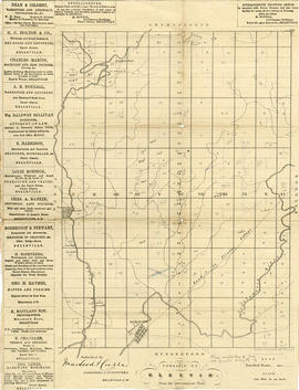
Part of Map collection
Map showing concessions, traveled roads and lots of Marmora Township, Hastings County. Areas of gold mines are also charted. Scale: 1 mile : 1 inch. Published by MacLeod & Carre Engineers and Surveyors in Belleville, Ontario (Canada West). Local advertisements surround map.
Received from the Public Archives of Canada on 3 May 1971.
MacLeod and Carre, P.L.S.

Part of Map collection
A map of Prince Edward County featuring information about local historical traditions, agriculture, community life and geography. Published in 1937 through Picton Times by Conger Allison. Dimensions: 72cm x 53cm.
Allison, Conger