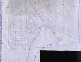
Map of Lot L on the Trent River
- CA ON00156 M/M440-1481
- Item
- 1878
Part of Map collection
A photostat of a map by from an H. Belden & Company's atlas showing Lot L on the Trent River - 1878.
Donated by K.G.M. Ross in 1963.
H. Belden & Company
104 results with digital objects Show results with digital objects
Map of Lot L on the Trent River
Part of Map collection
A photostat of a map by from an H. Belden & Company's atlas showing Lot L on the Trent River - 1878.
Donated by K.G.M. Ross in 1963.
H. Belden & Company
Map of the Town of Trenton 1875 (incomplete)
Part of Map collection
A partial map of the corporation of the Town of Trenton in 1875.
Depth chart of Trenton Harbour
Part of Map collection
A copy of an original map by W. Kingsford (Engineer in charge) showing the depths at various points in the Trenton Harbour on the Bay of Quinte - 1875. Scale: 1 : 9,800.
Photocopied by the Archives of Canada 21 Aug 1979.
Kingsford, William

Plan of the town plots of Trenton East
Part of Map collection
A certified reproduction of an original map showing a plan of the town plots in Trenton East. Specifically located in "Lot A in the core of Sidney". Scale: 1:2000.
Donated by Dorothy Ashton in 1987.
Map of proposed incorporation of the village of Trenton
Part of Map collection
A copy of an original map by J.S. Peterson showing the proposed incorporation of the village of Trenton - May 10, 1852.
Photocopied by the Archives of Canada 21 Aug 1973.
Peterson, J.S., P.L.S.

Diagram of Town plot called Trent Port
Part of Map collection
A copy of an original map by Deputy Provincial Surveyor F. P. Rubidge showing a diagram of a town plot at the mouth of the Trent River called the "Town of Trent Port." Specifically, the map shows Lot 2 near the 1st Concession bordering Murray Township in the County of Northumberland.
Published in Cobourg on September 25, 1852.
Donated by K.G.M. Ross.
Rubidge, Frederick Preston, D.P.S.
Map of Proposed bridge at mouth of the River Trent
Part of Map collection
A copy of an original map by N. H. Baird showing a harbour and bridge proposal at the Mouth of the River Trent - October 26, 1832.
Photocopied by the Archives of Ontario.
Baird, Nicol Hugh
Part of Map collection
A copy of an original map by Surveyor General John Collins showing land from Presqu'ile to Kingston in 1785. Scale: 4 miles : 1 inch.
Photocopied by the Archives of Canada 10 Jan 1990.
Collins, John, Hon.

Map of Murray Township showing several lots
Part of Map collection
A copy of an original map by Surveyor General David W. Smith showing several lots of land in Murray Township in the District of Newcastle. Specifically, the map shows Lots 1-5 near the 1st Concession and River Trent. Published by Henry Smith on July 24, 1799.
Donated by K.G.M. Ross in 1963.
Smith, David William
Road Map of Belleville, Trenton, Kingston, 2004
Part of Map collection
A Road Map of Belleville, Trenton, Kingston in 2004. Scale 1cm : 0.25 km. Composed by Peter Heiler Ltd. Published by Map Art Publishing.
Real Estate Board Map of Belleville and Trenton
Part of Map collection
A map featuring the streets in the City of Belleville and the Town of Trenton, as well as important buildings (e.g. schools, churches etc.).
Quinte and District Real Estate Board

City of Belleville map from Intelligencer
Part of Map collection
A map of the City of Belleville (with Trenton inset) featured in the September 20, 1961 issue of the Ontario Intelligencer. The map features houses that were open that week for viewing. At the bottom are sponsors of the map.
Intelligencer

Hastings with Town of Belleville and principal villages
Part of Map collection
A map of Hastings County including the Town of Belleville and other principal villages:
Trenton, Madoc, Marmora, Tweed, Bridgewater, Stirling, Wicklow, Bangor, Herschel, Monteagle, Carl, Dungannon, Wollaston, Limerick, Cashel, Tudor, Grimsthorpe, Elzevir; Rawdon, Huntingdon, Hungerford, Sidney, Thurlow, Tyendinaga.
Scale: 3 miles =1 inch. Published by John P. Evans, P.L.S. in 1869.
Evans, John Dunlop, P.L.S.
Map of City of Quinte West 2007
Part of Map collection
A map of Quinte West, Ontario featuring Frankford, Murray, Sidney and Trenton areas. Dated 2007.
Bay of Quinte Digital Mapping

Trenton Electric & Water Co. Limited in Sidney Township
Part of Map collection
An original map produced for the Trenton Electric & Water Co. Limited, concerning proposed transmission lines within the Township of Sidney. However, the map also features railways, roads and land boundaries. Circa 1910. Scale: 50 chains = 1 inch. Map composed by Smith, Kerry and Chace Engineers located in Toronto, Winnipeg, Calgary and Vancouver.
Donated by David Pershick.
Smith, Kerry and Chace Engineers

Seymour Power & Electric Co. Limited in Murray Township
Part of Map collection
An original map produced for the Seymour Power & Electric Co. Limited, concerning proposed transmission lines within the Township of Murray. However, the map also features railways, roads, mills and land boundaries. Circa 1910. Scale: 50 chains = 1 inch. Map composed by Smith, Kerry and Chace Engineers located in Toronto, Winnipeg, Calgary and Vancouver.
Donated by David Pershick.
Smith, Kerry and Chace Engineers
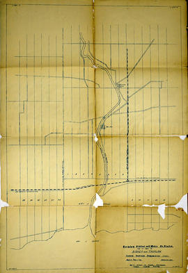
Trenton Electric & Water Co. Limited in Thurlow and Sidney Townships
Part of Map collection
An original map produced for the Trenton Electric & Water Co. Limited, concerning proposed transmission lines within the Townships of Thurlow and Sidney. However, the map also features railways, roads, mills and land boundaries. Dated March 31, 1910. Scale: 1/4 mile = 1 inch. Map composed by Smith, Kerry and Chace Engineers located in Toronto, Winnipeg, Calgary and Vancouver.
The map includes the first 4 concessions, Lots 33-38 in Sidney Township and Lots 1-13 in Thurlow Township.
Donated by David Pershick.
Smith, Kerry and Chace Engineers

Trenton Electric & Water Co. Limited in Thurlow Township
Part of Map collection
An original map produced for the Trenton Electric & Water Co. Limited, concerning their water mains, towers and substations within the Township of Thurlow. However, the map also features railways, roads and land boundaries. Circa 1910. Scale: 50 chains = 1 inch. Map composed by Smith, Kerry and Chace Engineers located in Toronto, Winnipeg, Calgary and Vancouver.
Donated by David Pershick.
Smith, Kerry and Chace Engineers

Town of Trenton with advertising businesses
Part of Map collection
A photocopy of a map of the Town of Trenton, circa 1915. The map features advertisements for local businesses, important sites, industries and many railways and stations.
Donated by Bruce Polmanter.
Plan of survey of part of Dundas Street, Town of Trenton
Part of Map collection
Registered Plans 258, 82, 64 - "Plan of survey of part of Dundas Street, Town of Trenton, showing property frontages and owners." Survey includes; Town of Trenton, part of Dundas Street on 2 sheets, including cross streets Flindal, Herman, Scott, and Campbell.
Allan, Stewart Walker, O.L.S.