Mostrar 817 resultados

Descrição arquivística
Land, settlement and immigration Imagem
Previsualizar a impressão Hierarchy Ver:

817 resultados com objetos digitais Mostrar resultados com objetos digitais

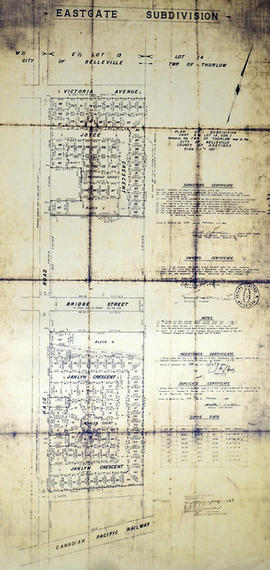
Subdivision of part of Lots 38-39 in the City of Belleville

A certified reproduction of the "Subdivision of part of Lots # 38 & 39. Reg. Plan No. 22, Belleville, owners Ross Robinson & Elizabeth Robinson.” The area includes; Lots # 1, 2, 3, Blocks A & B regarding widening at South East corner of Tracey St. and Lemoine Street. Surveyed by Walter I. Watson, O. L. S. and signed March 29, 1973.

Donated by Walter I. Watson, P. L. S.

Sem título

Subdivision of Lot 13 in the City of Belleville

A certified reproduction of the "Subdivision of part of the West ½ of Lot # 13, Concession 1, Township of Thurlow, now Belleville, owner Lambert-Rollins Construction Ltd.” The area includes; Block A, Lots # 1 to 41, Diamond Crescent, Flint Driver, and Haig Road. Surveyed by Walter I. Watson, O. L. S. and signed December 29, 1972.

Donated by Walter I. Watson, P. L. S.

Sem título

Subdivision of part of Lot 13 in the Township of Thurlow

A certified reproduction of the "Subdivision of part of Lot # 13, Concession 1, Township of Thurlow, Belleville.” The area includes; Lot # 1 to 11, and Block “A” South of Bridge Street East and West of Haig Road. Surveyed by Walter I. Watson, O. L. S. and signed October 18, 1973.

Donated by Walter I. Watson, P. L. S.

Sem título

Canadian National Railway System Map

"The Only Railway Serving All Ten Provinces of Canada:" a map showing the Canadian National Railway System in 1952. The map includes: Canadian National Railways, Grand Trunk Western Railroad Company, Central Vermont Railway Inc., Duluth, Winnipeg and Pacific Railway Company. Composed by C.N.R. Montreal. Scale 10/16 of an inch to 50 miles.

Donated by Bruce Polmanter.

Sem título

Map of the Counties of Hastings and Prince Edward

A "Map of the Counties of Hastings and Prince Edward." In 1898, the lots, concessions, churches, schools and mines are shown of the townships in Hastings and Prince Edward. Scale: 1.5 miles to an inch. Published by the Canadian Map Publishing Company in Hamilton, Ontario, for the Belleville Sun. Revised by Henry Carre, C.E. Inset is the map of North Hastings, scale 400 chains to an inch.

Sem título

East Gate Subdivision in the City of Belleville

A certified reproduction of the "Subdivision of Part of East ½ of Lot # 13, Concession 1, Township of Thurlow, now Belleville laid out for Maple View Realty Ltd. Pres. Maurice Rollins.” The area includes; Lots # 1 to 110 and Blocks A, B, C, D, E, F and Haig Road, Joyce Crescent, Richmond Grove, Janlyn Crescent, Whalen Court, all east of Haig Road. Surveyed by Walter I. Watson, O. L. S. and signed February 10, 1964.

Donated by Walter I. Watson, P. L. S.

Sem título

Part 1 of the Subdivision of Part of Lots 22-24 in the Township of Cashel

A certified reproduction of the "Subdivision of Part of Lots # 22, 23, & part of Broken Lot # 24, Concession 5, Township of Cashel and part of Lot # 22 & part of Broken Lots # 23, 24, Concession 4, Township of Cashel.” The area includes; northeast shore of Gunter Lake, east from the Narrows Little Salmon Lake (Cashel Lake) and along the shore to the creek. Surveyed by Browne, Cavell and Jackson, O.L.S. and signed October 28, 1963.

Donated by Walter I. Watson, P. L. S.

Sem título

Subdivision of Part of Lots 24-26 in the Township of Tudor

A certified reproduction of the "Subdivision of part of Lots # 24, 25, 26, Concession XIII, Township of Tudor, owner V. A. McMurray.” The area includes; Lots # 1 to 44, Blocks A to H, Glanmire Lake Road and Godfrey Road being north of the Road Allowance between Concession 12 & 13 and east of Road Allowance between Lots # 25 & 26. Surveyed by Michael J. McAlpine, O.L.S. and signed August 31, 1964.

Donated by Walter I. Watson, P. L. S.

Sem título

Registrar's Plan of Lot 25 in the Township of Sidney

A certified reproduction of the "Registrars' Compiled Plan. Part of Lot # 25, Concession 1 and Broken Front concession Township of Sidney.” The area includes; the Bay of Quinte to the Canadian National Railway, being along the east side of Montrose Road. Surveyed by Thomas S. Ransom, O. L. S. of Ransom & Watson, O. L. S. and signed March 30, 1965.

Donated by Walter I. Watson, P. L. S.

Sem título

Registrar's Plan of Lots 2-3 in the Township of Sidney

A certified reproduction of the "Registrar's Compiled Plan, of part of Lots # 2 and 3, Concession 2, Township of Sidney.” The area includes; part of Lots # 2 & 3, Concession 2, Sidney Township, northeast of Trenton. Surveyed by Ronald Benn, O. L. S. and signed March 31, 1965.

Donated by Walter I. Watson, P. L. S.

Sem título

Registrar's Plan of part of Lot 3 in the Township of Thurlow

A certified reproduction of the "Registrar's Compiled Plan: Part Lot # 3, Concession 2, Township of Thurlow, now City of Belleville.” The area includes; Lots # 1 to 24, west of North Front Street and north from Tracey Street. Prepared by S.C. Geneja CST, Registry Office, County of Hastings and signed March 23, 1966.

Donated by Walter I. Watson, P. L. S.

Sem título

Subdivision of part of Lot 26 in the Township of Bangor

A certified reproduction of the "Subdivision of part of Lot # 26, Concession XII, Township of Bangor, for Dept. Lands & Forests.” The area includes; Lot # 1 to 8 and Block A on the northeast shore of Kamaniskeg Lake, being part of Lot # 26, Concession XII of Bangor Township. Surveyed by M.J. McAlpine, O. L. S. and signed March 23, 1963.

Donated by Walter I. Watson, P. L. S.

Sem título

Subdivision of Elmwood Acres Extension in the Town of Trenton

A certified reproduction of the "Subdivision “Elmwood Acres Extension”, part [of] Lots # 5 & 6, Reg'd Plan No. 64, Town of Trenton- owner B E P Construction Ltd.” The area includes; west of town limits for the town of Trenton, west to Byron Street, Lots # 1 to 23 and Blocks A, B, C on North Elm Drive and Nelles Ave. Surveyed by Thomas S. Ransom, O. L. S. and signed February 14, 1963.

Donated by Walter I. Watson, P. L. S.

Sem título

Ontario Map from the National Topographic Series

A topographical map of Ontario from the Department of Mines and Technical Surveys, Surveys and Mapping Branch. Area includes west Lake Superior, east Quebec, north James Bay and south to Lake Erie. Dated April 30, 1956. Scale 1:63,360.

Sem título

Map of Thurlow Township with annotations

A map of Thurlow Township featuring the addition of handwritten annotations. Concessions, railways, proprietors, businesses and locations are featured. The map extends from the Bay of Quinte in the southwest to Roslin the northeast. Circa 1950 (Bakelite plant opened c. 1948 and the Foxboro Cheese Factory closed in 1961).

Specific annotations are as follows: Halloway Grist Mill, Latta Bridge, Plainfield Grist, Saw Mill, O'Brien's Bridge, Grist Mill, Canning Factory Foxboro, Footbridge, Cheese Factory, Fairfields Bridge, Dam Corbyville, Distillery, Cannifton Dam, Grist & Saw Mill, Quarry & Substation, Round House, Brickyard, Graham's Dried Foods, Bell Telephone Lines, Hydro Power Lines, and Cement Works.

Subdivision of part of Lots 1-2 in the Township of Wicklow

A certified reproduction of the "Subdivision of part of Lot # 1, Concession XI, part of Lot # 2, Concession XII, Township of Wicklow, prepared for Dept. Lands & Forests.” The area includes; Lots # 1 to 11, Lots # 1A, 2A, 3A, 4A, on the northeast shore of Papineau Lake. Surveyed by M. J. McAlpine, O. L. S. and signed June 3, 1960.

Donated by Walter I. Watson, P. L. S.

Sem título

Elmwood Acres Subdivision in the Town of Trenton

A certified reproduction of the "Elmwood Acres Subdivision of part Lots # 3 & 4, part of Birch Street...Town of Trenton, County of Hastings.” The area includes; Lots # 1 to 70, west of the Township of Sidney and east of Byron Street, being Lots on Elmwood Drive, Warren Road, Nelles Avenue and Birch Street. Surveyed by John Thomas Ransom, O. L. S. and signed October 8, 1960.

Donated by Walter I. Watson, P. L. S.

Sem título

Victoria Gardens Subdivision in the City of Belleville

A certified reproduction of the "Victoria Gardens Subdivision - part of east half of Lot # 10, Concession 1, now [the] City of Belleville. Owner- Lambert-Rollins Construction Ltd.” The area includes; north of Victoria Avenue, Lots # 1 to 70 on Rollins Drive and Clifford Crescent. Surveyed by John Thomas Ransom, O. L. S. and signed October 17, 1960.

Donated by Walter I. Watson, P. L. S.

Sem título

Subdivision of part of Lot 3 in the Township of Wicklow

A certified reproduction of the "Subdivision of part of Lot # 3, Concession 10, Township of Wicklow, prepared for Dept. of Lands & Forests.” The area includes; Lots # 1 to 12, Blocks A to D on the northwest shore of Papineau Lake. Surveyed by Michael J. McAlpine, O. L. S. and signed December 1, 1960.

Donated by Walter I. Watson, P. L. S.

Sem título

Subdivision of part of Lots 23-25 in the Township of Tudor

A certified reproduction of the "Subdivision of part of Lots # 23, 24, 25, Concession XIX, Township of Tudor.” The area includes; Lots # 1 to 28, Blocks A - B and Austin Bay Road along the shore of Bass Lake in Lot # 25, Concession XIX, Tudor Township. Surveyed by Thomas Ransom, O. L. S. and signed August 30, 1961.

Donated by Walter I. Watson, P. L. S.

Sem título

Resultados 61 a 80 de 817