Affichage de 188 résultats

Description archivistique
Sidney, Township of
Aperçu avant impression Hierarchy Affichage :

91 résultats avec objets numériques Afficher les résultats avec des objets numériques

Graphic Index of Lots 37-38, Belleville

  • CA ON00156 M/M440-2417
  • Pièce
  • 2 Jul 1968
  • Fait partie de Map collection

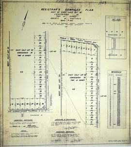
A certified reproduction of the "Registrar's Compiled Plan, being a graphic Index of Part of Lots # 37 and 38, Concession 1, Township of Sidney now City of Belleville.” The area includes;Lots # 1 to 50 Westerly from Sidney Street to Palmer Road and Northerly from Leland Drive to Bridge Street West. Surveyed by S. C. Geneja CST, Registry Office of Hastings and signed July 2, 1968.

Donated by Walter I. Watson, P. L. S.

Sans titre

Graphic Index of Lot 37, Belleville

  • CA ON00156 M/M440-2416
  • Pièce
  • 28 May 1968
  • Fait partie de Map collection

A certified reproduction of the "Registrar's Compiled Plan, being a graphic index of part of Lot # 37, Concession 1, Township of Sidney... now City of Belleville.” The area includes; Lots # 1 to 15 Westerly from Sidney Street to Palmer Road and Northerly from Bridge St. West to Moira Street West.. Surveyed by S. C. Geneja CST, Registry Office of Hastings and signed May 28, 1968.

Donated by Walter I. Watson, P. L. S.

Sans titre

Graphic Index of Lot 28, Belleville

  • CA ON00156 M/M440-2415
  • Pièce
  • 10 May 1968
  • Fait partie de Map collection

A certified reproduction of the "Registrar's compiled plan, being a graphic index of part of Lot # 28, Concession 1, Township of Sidney now City of Belleville.” The area includes; 14 Lots in Concession 1, west of Sidney Street and south of Moira Street. Surveyed by S. C. Geneja CST, Registry Office of Hastings and signed May 10, 1968.

Donated by Walter I. Watson, P. L. S.

Sans titre

Expropriation Plan for Water Resources, Belleville

  • CA ON00156 M/M430-2413
  • Pièce
  • 17 Jul 1967
  • Fait partie de Map collection

A certified reproduction of the "Expropriation Plan for Sewer Easement & Easement Uses only over Blocks “a” and “b” South of Dundas St. Plan 240- Trenton and over Lot # 2 Broken Front Concession, Township of Sidney, now Trenton. Prepared for Ontario Water Resources Commission.” The area includes; South of Dundas St. Trenton and along Bay St. Lot # 2 Broken Front Concession, being East of Flindal Street, Lots # 1 to 14. Surveyed by W. J. Pattison, O. L. S. and signed July 17, 1967.

Donated by Walter I. Watson, P. L. S.

Sans titre

Registrar's Complete Plan of Lot 26 in Sidney Township

  • CA ON00156 M/M430-2409
  • Pièce
  • 10 Mar 1967
  • Fait partie de Map collection

A certified reproduction of the "Registrar's compiled plan, part of Lot # 26, in Concession 1, Township of Sidney.” The area includes; part of Lot # 26, Concession 1, south of Canadian National Railway & Moira St. West. Registered March 10, 1967.

Donated by Walter I. Watson, P. L. S.

Registrar's Plan of Lot 26 in Sidney Township

  • CA ON00156 M/M430-2408
  • Pièce
  • 10 Mar 1967
  • Fait partie de Map collection

A certified reproduction of the "Registrar's compiled plan, part of Lot # 26, in Broken Front Concession Township of Sidney.” The area includes; Lots west ½ and east ½ of Lot 26, Broken Front, being the north of side of Hwy 2. Registered March 9, 1967.

Donated by Walter I. Watson, P. L. S.

Registrar's Plan of Lot 33 in Sidney Township

  • CA ON00156 M/M430-2407
  • Pièce
  • 9 Mar 1967
  • Fait partie de Map collection

A certified reproduction of the "Registrar's Compiled Plan of part of East half of Lot #33, Concession IV.” The area includes; part of the east half of Lot # 33, Concession IV, Sidney Township, Lot # 33 being between Wallbridge Loyalist Road on West and Philburn Rd. Surveyed by Ransom and Watson, O. L. S. and signed March 9, 1967.

Donated by Walter I. Watson, P. L. S.

Sans titre

Plan of part of the village of Frankford

  • CA ON00156 M/M430-2617
  • Pièce
  • April 1853
  • Fait partie de Map collection

A certified reproduction of a "Plan...of the village of Frankford. ” The area includes; part of Frankford Village westerly from King St. to Lots # 1-2 in Sidney Township and northerly from Sidney Street to Adelaide Street, including Cold Creek. Dated April 1853. Surveyed by J. S. Peterson, P.L.S.

This reproduction was made on April 9, 1981 and approved by the Land Registrar.

Donated by Walter I. Watson, P. L. S.

Sans titre

Boundary Lines Survey of Sidney Township, Con. 9

  • CA ON00156 M/M430-2534
  • Pièce
  • 18 Jul 1842
  • Fait partie de Map collection

A certified reproduction of the “Boundary Line Commissioners Survey of the 9th Concession of Sidney, for the Victoria District.” The area contained includes; the 9th Concession of Sidney Township, Block A and Lots # 1 to 38.. Originally surveyed by John Emerson D. P. S. and produced on July 18, 1842.

This reproduction was made on June 5, 1972 and approved by the Deputy Registrar.

Donated by Walter I. Watson, P. L. S.

Sans titre

Boundary Lines Survey of Sidney Township, Con. 5

  • CA ON00156 M/M430-2532
  • Pièce
  • 25 Nov 1840
  • Fait partie de Map collection

A certified reproduction of the “Boundary Line Commissioners Survey of the Fifth Concession of Sidney, for the Victoria District.” The area contained includes; Concession 5, Lot Block A and Lots # 1 to 32. Originally surveyed by Samuel M. Benson, D. P. S. and produced on November 25, 1840.

This reproduction was made on June 5, 1972 and approved by the Deputy Registrar.

Donated by Walter I. Watson, P. L. S.

Sans titre

Boundary Lines Survey of Sidney Township, Con. 3

A certified reproduction of the “Boundary Line Commissioners Survey of the Third Concession of Sidney, for the Victoria District.” The area contained includes; Sidney Township, Concession 3, Lots: Block A and Lots # 1 to 38. Originally surveyed by John Emerson, P. L. S. and produced circa 1841. This reproduction was made on June 5, 1972 and approved by the Deputy Registrar.
Donated by Walter I. Watson, P. L. S.

Sans titre

Boundary Lines Survey of Sidney Township, Con. 2

  • CA ON00156 M/M430-2530
  • Pièce
  • 4 Sep 1840
  • Fait partie de Map collection

A certified reproduction of the “Boundary Line Commissioners Survey of the Second Concession of Sidney, for the Victoria District..” The area contained includes; Sidney Township, Concession 2, Lot Block A and Lots # 1 to 38. Originally surveyed by John Emerson, P. L. S. and produced on September 4, 1840. This reproduction was made on June 2, 1972 and approved by the Deputy Registrar.
Donated by Walter I. Watson, P. L. S.

Sans titre

Boundary Lines Survey of Sidney Township, Con. 1

  • CA ON00156 M/M430-2529
  • Pièce
  • 6 Jun 1841
  • Fait partie de Map collection

A certified reproduction of the “Boundary Line Commissioners Survey of Sidney Township. First Concession and Broken Front, for the Victoria District.” The area contained includes; Sidney Township, Concession 1 and the Broken Front Lots # 5 to 38. Originally surveyed by John Emereson, P. L. S. and produced on June 6, 1841. This reproduction was made by the Archives of Ontario.

Donated by Walter I. Watson, P. L. S.

Sans titre

Sidney Township, Pipeline Map # 21R-1763

  • CA ON00156 M/M430-2621
  • Pièce
  • 17 Dec 1974
  • Fait partie de Map collection

"Sidney Township, Map # 21R-1763" of the "Interprovincial Pipe Line Ltd, Survey of part of Lots # 25, 26, 27, 28 Concession 3, Township of Sidney." Produced on December 17, 1974. Scale: 1 inch = 200 ft. Surveyed by Edward J. Grenkie, O. L. S.

Donated by Walter I. Watson, P. L. S.

Sans titre

Sidney Township, Pipeline Map # 21R-1762

  • CA ON00156 M/M430-2620
  • Pièce
  • 17 Dec 1974
  • Fait partie de Map collection

"Sidney Township, Map # 21R-1762" of the "Interprovincial Pipe Line Ltd, Survey of part of Lots # 21, 22, 23, 24 Concession 3, Township of Sidney." Produced on December 17, 1974. Scale: 1 inch = 200 ft. Surveyed by Edward J. Grenkie, O. L. S.

Donated by Walter I. Watson, P. L. S.

Sans titre

Sidney Township, Gas Line Map # RL32532

"Sidney Township, Map # RL32532." A "Plan showing a survey of a Gas Pipe Line Right of Way though Lots # 20 to 29 inclusive, Concession 3, Township of Sidney, County of Hastings." Surveyed in 1958 by Marshall, Macklin & Monaghan, O. L. S Scale: 1 inch = 400 ft.

Donated by Walter I. Watson, P. L. S.

Sans titre

Sidney Township Map # 442773E

  • CA ON00156 M/M470-2591 - 2616/2591
  • Pièce
  • c. 1950
  • Fait partie de Map collection

A reproduction of an air survey photograph produced by the Ontario Ministry of Natural Resources. Map # 442773E of Sidney Township in Hastings County, Ontario. Circa 1950.

The photograph shows Sidney Township, Concession 1 to 8, Lots # 1 to 25, Hwy 33 and the Trent Canal and Frankford Village, southeast part of Murray Township.

Donated by Walter I. Watson, P. L. S.

Sans titre

Air Surveys of Hastings County, Ontario

  • CA ON00156 M/M470-2622 - 2625
  • Pièce
  • 1982
  • Fait partie de Map collection

All air surveys were published in 1982. Scale 1; 10,000. By the Ontario Ministry of Natural Resources, Map base by Survey and Mapping Branch, Air Photography.

1) M470-2622. Rawdon Township Map # 10-18-2900-49050 showing areas of; the South West area of Rawdon Township, Concession 1 & 2 and Marsh Creek Watershed, Anson (Station) on the C. N. R. and part of Sidney Township, Concession 8.

2) M470-2623. Sidney Township, Map # 10-18-2900-49000 showing areas of; the Northwest area of Sidney Township being Trent River and Canal System including Wilson Island, Glen Ross, Richardson Cove, Heagles Island and South to Concession 6, Township of Sidney.

3) M470-2624. Sidney Township, Map # 10-18-2950-49000 showing areas of; Sidney Township, Concession 6, 7 and 8, Lots # 16 to 26, including part of Rawdon Creek, Oak Lake, Stirling Airfield..

4) M470-2625. Stirling, Map # 10-18-2950-4905 showing areas of; the Village of Stirling and surrounding area of Sidney & Rawdon Townships.

Sans titre

Map of Hastings County in 4 sections

A map of Hastings County outlining townships from the Bay of Quinte in the south, to Wallaston, Limerick and Cashel in the north.
Map is in four sections. Scale: 3 miles : 1 inch. Original map is dated 1894. Photocopy from the Archives of Ontario.

Map of District of Prince Edward County

Map showing townships in the District of Prince Edward County: South Murray, Sidney, Thurlow, Ameliasburgh, Sophiasburgh. See boundary lines on map. Surveyed by Publius Virgillius Elmore, D.L.S. Dated 1835. Map copied from the Archives of Ontario.

Sans titre

Résultats 101 à 120 sur 188