Mostrando 133 resultados

Descripción archivística
Madoc, Township of
Imprimir vista previa Hierarchy Ver :

49 resultados con objetos digitales Muestra los resultados con objetos digitales

Madoc Township Map # 445772W

  • CA ON00156 M/M470-2591 - 2616/2609
  • Unidad documental simple
  • c. 1950
  • Parte deMap collection

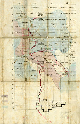
A reproduction of an air survey photograph produced by the Ontario Ministry of Natural Resources. Map #445772W of Madoc Township in Hastings County, Ontario. Circa 1950.

The photograph shows Madoc Township, Concession 5 to 9, Huntingdon Township Concession 14, northwest Elzevir Township, Queenboro and Black River.

Donated by Walter I. Watson, P.L.S.

Sin título

Election Canada Districts in Centre Hastings

  • CA ON00156 M/M480-2646 - 2652 and 2654/2646
  • Unidad documental simple
  • 2003
  • Parte deMap collection

2 copies of maps detailing electoral districts #40 to 45 (inclusive) within Centre Hastings. The map includes polling divisions, road networks and municipal boundaries. Inset # 2, # 35073.

Sin título

Aerial Photograph of Madoc Township

  • CA ON00156 M/M470-2781 - 2794/2781
  • Unidad documental simple
  • c. 1977
  • Parte deMap collection

Madoc Township, Map # A18256-148 showing areas of Hwy 62 at Bannockburn and the road east to Cooper. The railway parallel with Hwy 62. The Ontario Hydro easement running west from Cooper. By the Air Photographic Production Division of the Deptartment of Mines & Technical Surveys - Government of Canada.

Sin título

Blackburn family papers

  • CA ON00156 2011-13
  • Fondo
  • 1901-1930

Collection contains:
1) Twelve letters from Nicholas Wood Blackburn to his future wife, Fannie Elizabeth 'Lizzie' Bateman and one from Lizzie to Nicholas, 1901-1902. Letters from Nicholas were written from Marmora, Blairton, Rat Portage [Kenora], Macdonald (Manitoba), Millbridge, Coe Hill Mines, L'Amable Station, and Turriff.
2) Colour photocopy of certificate of marriage of Nicholas Wood Blackburn and Fannie E. Bateman, 25 March1903
3) Last will and testament of Nicholas Wood Blackburn of Madoc Township, 1918
4) Photocopied diary entries of Lizzie Blackburn at the time of Nicholas's last illness, 1929-1930
5) Photocopy of a letter from the nurse who tended Nicholas Blackburn before his death, 1 January 1930

Sin título

The Gladys Rollins Collection

This file contains: 1) A photocopied typed article titled "Telegraph Island Light", about the lighthouse erected 1870 in the Bay of Quinte; 2) A timetable for the steamer Varuna, circa 1920, Captain A. Hicks; 3) A photocopy of the obituary for Rev. James Rollins born 28 October 1865 in Madoc and died 7 February 1943 in Kingston.

Map of Hastings with the Principal Villages and the City of Belleville

  • CA ON00156 M/M420-1088
  • Unidad documental simple
  • 1879-1880
  • Parte deMap collection

A map of Hastings County including the Town of Belleville and other principal villages:

Trenton, Madoc, Marmora, Tweed, Bridgewater, Stirling, Wicklow, Bangor, Herschel, Monteagle, Carl, Dungannon, Wollaston, Limerick, Cashel, Tudor, Grimsthorpe, Elzevir; Rawdon, Huntingdon, Hungerford, Sidney, Thurlow, Tyendinaga.

Scale: 3 miles =1 inch. Published by Evans & Bolger, P. L. Surveyors, P.L.S. in 1879-1880.

Sin título

Townships of Hastings County with advertisements

  • CA ON00156 M/M420-1104
  • Unidad documental simple
  • 1932
  • Parte deMap collection

A map of Hastings County, in 1932, showing lakes, rivers, cities, towns and townships. A list of businesses within the county are on the right. Drawn exclusively for and published by Croydon Publishing Company.

Sin título

Map of Hastings with townships

  • CA ON00156 M/M420-1101
  • Unidad documental simple
  • c. 1916
  • Parte deMap collection

A map of Hastings County outlining the twelve townships:
Marmora and Lake, Madoc, Tudor, Grimsthorpe, Elzevir; Rawdon, Huntingdon, Hungerford, Sidney, Thurlow, Tyendinaga.
As well as, the lots and concessions. Circa 1916.Scale: 4 miles: 1 inch.

Donated by K.G.M. Ross.

Plans for St Peter's Presbyterian Church

  • CA ON00156 M/M450-1504
  • Unidad documental simple
  • c. 1850
  • Parte deMap collection

A set of plans for St. Peter's Presbyterian Church in Madoc, Hastings County, Ontario. The church itself opened in 1850. Scale: 8 feet : 1 inch.

Reproduction from the Archives of Ontario.

Plan of the Village of Madoc

  • CA ON00156 M/M430-1909
  • Unidad documental simple
  • c. 1878
  • Parte deMap collection

A certified reproduction of the "Plan of Village of Madoc situated on part of Lots # 1-3, Concession 5-6 and Lot # 2, Concession 7 in Township of Madoc and part of Lots # 11 & 12, Concession 14 in Township Huntingdon. Compiled from Registered Plans and Actual Surveys." Surveyed by Evans and Bolger, P.L.S., circa 1878.

This copy was made in 1972 of plan #218, as registered in the Hastings Land Registry Office.

Donated by Walter I. Watson, O.L.S.

Sin título

Plan of subdivision of Town Lot 2 in the Township of Madoc

  • CA ON00156 M/M430-1971
  • Unidad documental simple
  • 3 Apr 1889
  • Parte deMap collection

A certified reproduction of the "Plan of subdivision into Town Lots - part of the south half of the east half of Lot # 2, Concession 5, Township Madoc - for June Whytock witnessed by David Whytock.” Surveyed by C. Fraser Aylsworth Jr., P.L.S., and signed April 3, 1889.

This copy was made in 1972 of plan #281, as registered in the Hastings Land Registry Office.

Donated by Walter I. Watson, P. L. S.

Sin título

Plan of Lakeview Cemetery in the Township of Madoc

  • CA ON00156 M/M430-1977
  • Unidad documental simple
  • 23 Oct 1891
  • Parte deMap collection

A certified reproduction of the "Plan of Lake View Cemetery, situated on the west half of Lot # 1, Concession 7, Madoc Township.” Surveyed by C. Fraser Aylsworth Jr., P.L.S., and signed October 23, 1891.

This copy was made in 1972 of plan #287, as registered in the Hastings Land Registry Office.

Donated by Walter I. Watson, P. L. S.

Sin título

Map of Lots 1-19 in Madoc Township

  • CA ON00156 M/M430-2013
  • Unidad documental simple
  • c. 1878
  • Parte deMap collection

A original plan of Lots 1 to 19 on Concessions 4 to 7 in Madoc Township, with proprietor names on Lots # 8 to 19 on Concessions 8 to 19. The plan is undated, however the proprietors match those of Belden's 1878 Atlas.

The village of Madoc is located at the south. On the left side is presumably part of a legend regarding land use.

Donated by the Glanmore National Historic Site in 2016.

Madoc Township : history of Bannockburn

File contains original and photocopied manuscript histories of the settlement and early development of Bannockburn including the lumbering and sawmilling industries. Includes a printout of a webpage on Maitland House (available on the Internet Archive's Wayback Machine at https://web.archive.org/web/20010805101431/http://casa-de.vrx.net/buildings/) and an article from the Fall 2019 Country Roads magazine about the conversion of St. Bartholomew Anglican Church in Bannockburn into a private home.

Resultados 61 a 80 de 133