A map of the Paleozoic geology featured in the Tweed-Kaladar area during 1981. Scale 1:50,000. Published by the Ontario Ministry of Natural Resources.
Funded by the Federal Department of Regional and Economic Expansion and the Ontario Ministry of Natural Resources under the Minerals Program of Eastern Ontario Subsidiary Agreement.
Ontario. Ministry of Natural Resources and Forestry
A map describing areas of land ownership and fish species in Bancroft/Mazinaw. The map covers the following townships: Hastings County: Lake, Tudor & Grimsthorpe Lennox and Addington County: Ashby, Denbigh, Effingham, Abinger & Anglesea Frontenac County: Barrie, Clarendon, Miller, North Canonto, South Canonto, & Palmerston
Scale 1cm:1km. Published by the Ontario Ministry of Natural Resources in 1993.
Ontario. Ministry of Natural Resources and Forestry
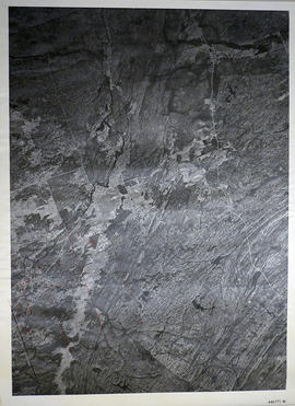
A reproduction of an air survey photograph produced by the Ontario Ministry of Natural Resources. Map #446771W of Kaladar Township in Lennox and Addington County, Ontario. Circa 1950.
The photograph shows Kaladar Township, Concession 1 to 7, Hwy 41, Northbrook and west to Flinton, the Skootamata River and the border of Anglesea Township.
Donated by Walter I. Watson, P.L.S.
Ontario. Ministry of Natural Resources and Forestry
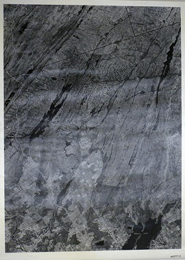
A reproduction of an air survey photograph produced by the Ontario Ministry of Natural Resources. Map #445771E of Sheffield Township in Lennox and Addington County, Ontario. Circa 1950.
The photograph shows Sheffield Township, Concession 3 to 9, Beaver Lake and north to Kaladar Township, Concession VIII to XI, Lingham Lakes in Grimthorpe Township in Hastings County.
Donated by Walter I. Watson, P.L.S.
Ontario. Ministry of Natural Resources and Forestry
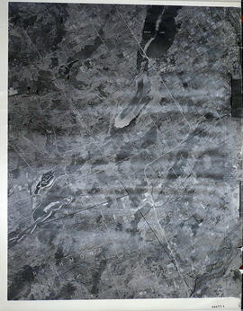
A reproduction of an air survey photograph produced by the Ontario Ministry of Natural Resources. Map #444771E of Sheffield Township in Lennox and Addington County, Ontario. Circa 1950.
The photograph shows the southwest part of Sheffield Township, Concession 1 to 6, Hwy 49, northwest corner of Camden East, northeast corner of Richmond Township and southeast corner of Hungerford with Village of Marlbank and Lime Lake.
Donated by Walter I. Watson, P.L.S.
Ontario. Ministry of Natural Resources and Forestry
A reproduction of an air survey photograph produced by the Ontario Ministry of Natural Resources. Map #443771E of Richmond Township in Lennox and Addington County, Ontario. Circa 1950.
The photograph shows Richmond Township and the east part of Tyendinaga Township.
Donated by Walter I. Watson, P.L.S.
Ontario. Ministry of Natural Resources and Forestry
A map of the Napanee Administrative District including Northumberland, Hasting County, Prince Edward County, Lennox Addington counties. Published by the Ministry of Natural Resources in 1980.
Donated by the Belleville Public Library in 2014.
Ontario. Ministry of Natural Resources and Forestry