- CA ON00156 2010-41
- Item
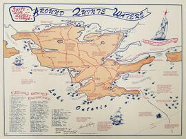
- c.1980
Map showing the location, names and dates of shipwrecks around the shoreline of Prince Edward County.
Ralley, Allan A.
34 results with digital objects Show results with digital objects
Map showing the location, names and dates of shipwrecks around the shoreline of Prince Edward County.
Ralley, Allan A.

Sprague Family, Prince Edward County History
This file contains a newspaper clipping titled "The Sprague Family: How They Migrated From New York to Prince Edward".

Prince Edward Militia : court martial, 1839
File contains a newspaper clipping regarding a document about a June 1839 court martial trial held in Consecon, Ontario, of thirty-five members of the Prince Edward Militia charged with various offences.
Part of County of Hastings records
Digital copy of 1886 Directory of the Counties of Frontenac, Hastings, Lennox, Addington, Prince Edward
The file contains a commemorative pamphlet on the history of the Weller's Stage Coach, along with a copy of an advertisement from the Cobourg Star (11 August 1841).
This file contains: 1) A photocopied typed article titled "Telegraph Island Light", about the lighthouse erected 1870 in the Bay of Quinte; 2) A timetable for the steamer Varuna, circa 1920, Captain A. Hicks; 3) A photocopy of the obituary for Rev. James Rollins born 28 October 1865 in Madoc and died 7 February 1943 in Kingston.
The file contains a letter dated 9 May 1924 from Harwood Weller Quipp looking for information about the Weller Family of Carrying Place. Also, two newspaper articles; one on the death of Lottie Weller (nee Bingley) and one dated 14 April on the 105th Birthday of Mrs. Laura Weller (nee Roberts). Both women descending from local pioneer families.
Wellington Marbelite Brick Company
The file contains a certificate 10 shares of common stock in the Wellington Marbelite Brick Company, dated 23 May 1930.
Map of Rivers and Lakes of Prince Edward County
Part of Map collection
Map showing depths of water and fishing areas[?] of the Bay of Quinte, from Belleville to Big Island and North Port.
van Burren, Jack

Hydrographic Map of Bay of Quinte, Picton to Presqu'ile Bay
Part of Map collection
A hydrographic map of the area surrounding the Bay of Quinte, Picton to Presqu'ile Bay in Ontario, Canada. With maps of Trenton Approaches, [racist slur redacted] Narrows, Belleville Harbour & Telegraph Narrows inset. Surveys completed in in 1952-53 and 1957. Map printed June 15, 1962. Published by the Canadian Hydrographic Service, Marine Sciences Branch, Department of Mines and Technical Surveys, Ottawa. Sheet number 2069.
Canadian Hydrographic Service

A family history on the Wilkins' family. 2 pages.
Topographical maps of Wellington
Part of Map collection
A topographical map of Wellington - Canada sheet #30 N/14, both east and west half sheets. Published by the Army Survey Establishment, Department of National Defence in 1951. Scale 1:50,000.
Canada. Department of National Defence

Topographical map of Duck Island
Part of Map collection
A topographical map of Duck Island- Canada sheet #30 N/15. Published by the Army Survey Establishment, Department of National Defence in 1932. Scale one inch to one mile - 1/63, 360.
Donated by Gerry Boyce.
Canada. Department of National Defence
Discovery Tour of Loyalist Country (pamphlet)
Part of Map collection
A pamphlet describing a 250km tour of historical attractions within Hastings, Prince Edward, Lennox and Addington counties. The history of each destination (e.g. the Macpherson House) is given, as well as its location on a map.
Ontario Heritage Foundation
Letter of complaint about the state of buildings in Prince Edward County. In the same file are three pages of extracts from the publication 'Over the Hills of Hastings', 1923.
Chaplin, Colin E.
Newspaper clipping about retirement of Percy Wilson, Clerk of Hillier Township
Article by D. K. Redner in the Picton Gazette on the career of Percy Wilson.
Picton Gazette Publishing Company
Preliminary Bibliography of the Trent Watershed
List of publications relating to the Trent River watershed compiled by Larry P. Turner of the Ontario Ministry of Natural Resources.
Ontario. Ministry of Natural Resources and Forestry
Printed short history of Prince Edward County.
Prince Edward Historical Society

Topographic Map of Ontario - Belleville Sheet
Part of Map collection
A map from the Eastern Canada series entitled "Topographic Map of Ontario - Belleville Sheet 31 C/3." The map includes Hastings County to Hillier in Prince Edward County. Published in 1938 by the Department of National Defence. Scale 1 inch to 1 mile.
Donated by the Belleville Public Library in 2014.
Canada. Department of National Defence
Photocopies taken from 2 Bibles donated to Belleville Public Library by Robert B. Redner in 1984. Records of births, deaths and marriages include family names: Osterhaout, Redner, Huyak, Wright, Conger, Patterson Clute, Goldsmith, Minaker, Tompkins, Wolever, Delong, Gordon and Baird.