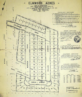
A certified reproduction of the "Elmwood Acres Subdivision of part Lots # 3 & 4, part of Birch Street...Town of Trenton, County of Hastings.” The area includes; Lots # 1 to 70, west of the Township of Sidney and east of Byron Street, being Lots on Elmwood Drive, Warren Road, Nelles Avenue and Birch Street. Surveyed by John Thomas Ransom, O. L. S. and signed October 8, 1960.
A certified reproduction of the "Forest Hill Subdivision of Part East ½ Lot # 11, Concession 1 Township of Thurlow, prepared for Barbara MacDonell.” The area includes; east of Farley Avenue, from Bridge Street East north to Pine Street, being the east half of Lot # 11, Concession 1, Thurlow Township. Surveyed by John T. Ransom, O. L. S. and signed November 8, 1956.
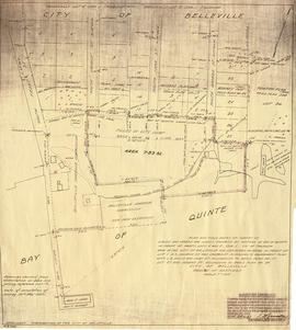
A map showing a plan for the Belleville Harbour. The total area stretches from south Front Street to the Ponton Plan. Published by John T. Ransom on May 19th, 1947. The map features field notes of survey of lands, marshes and Bay of Quinte waters. Scale: 1':100'.
Two maps: 1) Plan of Belleville Harbour area, South Front Street, South Church Street, South John Street and South George Street, showing filled-in city dump area and former shoreline, by John T. Ransom, 1947 2) Plan of the mouth of the Moira river, showing the CPR railway bridge and filled-in land, by Tom Ransom, 1961
A map showing a plan of survey for lots 4, 5, 6, 7, 8, 9 and lots 37, 38, 39, 40 on the south side of Bridge Street East between Dufferin and Macdonald Avenues in Belleville, Ontario. Surveyed by John T. Ransom on March 1, 1951 and amended April 14, 1960. Scale: 1'':50'.
A certified reproduction of the "Plan of Resurvey of part of Township of Lake.” The area includes; Township of Marmora as the south boundary, Township Methuen as the west boundary, and the Township of Wollaston as the north boundary. Surveyed by John T. Ransom, O. L. S. and signed November 18, 1949.
This copy was made in 1972 of plan #840, as registered in the Hastings Land Registry Office.
A certified reproduction of the "Plan of subdivision of part Lot # 28, Reg. Plan No. 65, Township of Thurlow.” The area surveyed includes; east of Herchimer Avenue, being 15 Lots on both sides of Symington Drive. Surveyed by John T. Ransom, O. L. S. and signed June 22, 1955.
This copy was made in 1972 of plan #991, as registered in the Hastings Land Registry Office.
A certified reproduction of the "Plan of Survey of part Lots # 7 & 8, Reg. Plan No. 65, Township of Thurlow.” The area surveyed includes; west of Herchimer Avenue, Lots on both sides of Crestview Avenue and both sides of Rosewood Avenue. Surveyed by John T. Ransom, O. L. S. and signed March 1, 1955.
This copy was made in 1972 of plan #984, as registered in the Hastings Land Registry Office.
A certified reproduction of the "Resubdivision of part Reg'd Plan 171, as follows, Lots # 12,13, 14,15 and 16 and parts of 10,11,17 west of Annie Rose Street...Township of Thurlow.” The area includes; south of Maple Drive, both sides of Jackson Avenue and Highview Crescent and Annie Rose Street. Surveyed by John Thomas Ransom, O. L. S. and signed October 9, 1956.
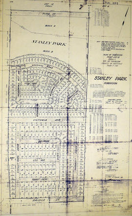
A certified reproduction of the "Stanley Park Subdivision, part of Lot # 12, Concession 1, Township of Thurlow, Stanley Park Ltd. Owner John M. Parrot & Bernice W. Parrot.” The area includes; east of Farley Avenue and north of Bridge Street East, Lots # 1 to 294 and Block A-C. Note, Blocks B and C are dedicated for Park & School purposes. Surveyed by John Thomas Ransom, O. L. S. and signed February 14, 1958.
A certified reproduction of the "Subdivision of Blocks A and B, Part Lots # 52 to 64 inclusive Reg. Plan 985.” The area includes; south of Victoria Avenue, and west of Farley Avenue, being both sides of Smith Crescent and west side of Farley Avenue. Surveyed by John T. Ransom, O. L. S. and signed April 20, 1956.
A certified reproduction of the "Plan of Subdivision of Part Lot # 35, Concession 1 Sidney owner Frank Follwell.” The area surveyed includes; Part Lot # 35, Concession 1, Sidney Township, Lots on both sides of Wright Avenue and Glen Road. Surveyed by John T. Ransom, O. L. S. and signed March 10, 1955.
This copy was made in 1972 of plan #982, as registered in the Hastings Land Registry Office.
A certified reproduction of the "Subdivision of Lot # 6, east of North Park Street, Government Plan,Township of Thurlow.” The area includes; east of North Park Street and both sides of North Park Gardens. Surveyed by John Thomas Ransom, O. L. S. and signed August 25, 1948.
A certified reproduction of the "Plan of Subdivision of part of Lot A, Concession IV, Township of Sidney, prepared for Bata Shoe Co. of Canada Ltd.” The area surveyed includes; Lot A, Concession IV, south of Bata Road and west of Frankford Road being Lots in Sidney Crescent. Surveyed by John T. Ransom, O. L. S. and signed July 2, 1955.
This copy was made in 1972 of plan #993, as registered in the Hastings Land Registry Office.
A certified reproduction of the "Subdivision of part Lots # 11 & 12, Concession 13, Township of Huntingdon.” The area includes; Moira Lake, old County Road Hwy 62 and proposed new bridge. Surveyed by John Thomas Ransom, O. L. S. and signed November 10, 1960.
A certified reproduction of the "Subdivision of part Lots # 12 & 13, Concession XIII, Township of Huntingdon.” The area includes; north shore of Moira Lake, and east of County Road No. 1. Surveyed by John Thomas Ransom, O. L. S. and signed March 13, 1957.
A certified reproduction of the "Subdivision of Lot # 13 and part Lots # 12 & 14, east of MacDonald Avenue, Registered Plan 123, Township of Thurlow.” The area includes; east of MacDonald Avenue, north of MacDonald Gardens, both sides of Cherry Gardens, and west of County Farm. Surveyed by John Thomas Ransom, O. L. S. and signed April 30, 1948.
A certified reproduction of the "Subdivision [of] Lots # 1 to 7, east side Trent Street (formerly Walter Street). Lots # 1 to 9 west side of Delaney Street (formerly Henry Street). Lot # 6 and...Lot # 5, East side of Delaney Street (formerly Henry Street). Reg. Plan 219 Town of Trenton.” Surveyed by John T. Ransom, O. L. S. and signed March 8, 1949.
This copy was made in 1972 of plan #825, as registered in the Hastings Land Registry Office.
A certified reproduction of the "Subdivision: Part of Lots # 21 & 22, East of MacDonald Ave, Reg. Plan 123 City of Belleville.” The area includes; east of MacDonald Avenue being Lots on Eastwood Park Drive. Surveyed by John T. Ransom, O. L. S. and signed February 15, 1954.
This copy was made in 1972 of plan #935, as registered in the Hastings Land Registry Office.
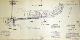
A certified reproduction of the "Subdivision of part Lots # 22 & 23, Concession XIX, Township of Tudor, for Herbert Moore.” The area includes; shore property between Bass Lake and Moore's Road being Lots # 30 to 46, inclusive, beginning at Concession Road between Townships of Tudor & Limerick. Surveyed by John Thomas Ransom, O. L. S. and signed August 9, 1957.