Showing 1076 results

Archival description
Map collection Hastings, County of
Print preview Hierarchy View:

813 results with digital objects Show results with digital objects

The Association of Canadian Clubs Banner

A banner for the Association of Canadian Clubs.

The Women's Canadian Club of Belleville was formed January 31, 1914 to foster Canadian patriotism and presumably dissolved in 1970. It was a member of the Association.

Map of Hastings and Prince Edward Counties

A map showing the roads, forts and inns of Hastings and Prince Edward Counties in 1850, by Major Baron DeRottenburg. The map extends from Brighton to Gananoque, Prince Edward County. and North to include Rawdon, Huntingdon, Hungerford Townships of Hastings County. Scale: 2 miles = 1". Dimensions 63cm x 44cm.

DeRottenburg, Major Baron

Map Hastings, Prince Edward, Northumberland and Peterborough Counties

A map of Hastings, Prince Edward, Northumberland and Peterborough counties in 1916 from the Department of Interior Canada. Published by J.E. Chalifour, Chief Geographer. Scale: 3" to 95 miles. Dimensions 63.5cm x 96.5cm.

The legend includes additional information about counties, towns, villages, boundaries, railways, canals, lots, concessions, portages, rapids and First Nations Territories.

Canada. Department of the Interior

Plan of village of Hastings in 1850

A certified reproduction of the "Plan of Village of Hastings on west half of Lot # 1 in 6th Concession of Township of Madoc for Uriah Seymour." Surveyed in May of 1850 by P. Elmore, P. L. S. A Furnace building and other buildings are depicted on a Common between the bridge and dam.

This copy was made in 1976 of plan #13, as registered in the Hastings Land Registry Office.

Donated by Walter I. Watson, O.L.S.

Elmore, Publius Virgillius, D.P.S.

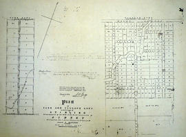
Plan of Park and Village Lots in Stirling

A certified reproduction of the "Plan of Park and Village Lots in Village of Stirling. Being Lot # 23 in 9th Concession of Sidney Township for James Ross." Surveyed by John J. Haslett, P.L.S. in 1852.

This copy was made in 1972 of plan #16A, as registered in the Hastings Land Registry Office.

Donated by Walter I. Watson, O.L.S.

Haslett, John James, P.L.S. & D.P.S.

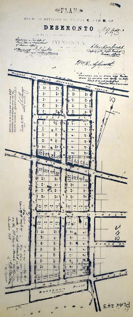
Plan of Blocks K and M in the town of Deseronto

A certified reproduction of the "Plan showing of Blocks K and M of Deseronto, on west plot of Lot 3, Concession A, Township of Tyendinaga.” Blocks K and M are from Main Street north to the original Concession Road Allowance, west to Brant Street, and east to Mill Street. Plan signed by William R. Aylsworth, P.L.S. and dated March 26, 1885.

This copy was made in 1972 of plan #243, as registered in the Hastings Land Registry Office.

Donated by Walter I. Watson, P. L. S.

Aylsworth, William Robert, O. L. S.

Teacher's Guide to Quinte in 1785

Map showing the Bay of Quinte to Presqu'ile to the eastern tip of Grande Isle (Wolfe Island) used as a teacher's guide to the area in 1785. The 20th century names are in capital letters as per the Legend.

Water Communication between the Bay of Quinte and Lake Huron

Map showing a measured sketch of the water communication between the Bay of Quinte and Lake Huron, May 1818. The total area extends from the Bay of Quinte and Lake Huron by Rice Lake to the falls of the River Trent to its mouth. A reproduction from the Archives of Canada.

Reproduction of Murray Canal Plan

"Murray Canal Plan Showing Portions of the Old Canal Reserve Which It is Proposed to Grant to the Province of Ontario."
A reproduction from an original at the Archives of Canada's map collection.

Map of Watersheds of the Moira and Napanee Rivers

A map of the Watersheds of the Moira and Napanee Rivers, 1950. From the Department of Planning and Development by A. H. Richardson, Chief Conservation Officer. Dimensions: 48cm x 35.5cm.

Richardson, A.H.

Map of the Moira Region Watershed

A map of the Moira Region Watershed. Polychrome colours symbolize the varieties of soils and land use surveys, see Legend. Not dated, circa 1950. Published by the Ontario Department of Planning and Development, Conservation Branch. Dimensions 58.5cmx 69cm.

Ontario. Department of Planning and Development

Flood Risk Maps of the Lower Trent Region

7 flood risk maps for the Lower Trent Region. Part of the Canada-Ontario Flood Damage Reduction Program.

Ontario. Ministry of Natural Resources and Forestry

Flood Risk Maps of the Moira River

Flood risk map numbers 1, 2, 3 and 4 for the Moira River. Part of the Canada-Ontario Flood Damage Reduction Program.

Ontario. Ministry of Natural Resources and Forestry

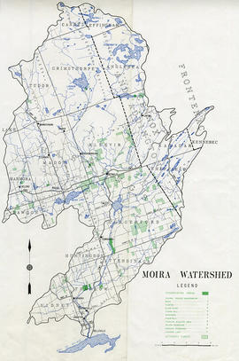
Map of the Moira Watershed

A map of the Moira Watershed showing conservation areas, authority forests and the location of large bodies of water.

Land Use Survey of the Moira Watershed

"Moira Watershed Land Use Survey [for] Recommended Land Use." The varieties of land use include unrestricted, conservation farming, restricted use, permanent vegetation and woodland. Published by the Ontario Department of Planning Development, Conservation Branch in 1950.

Ontario. Department of Planning and Development

Reforestation Land and Existing Woodland in the Moira Watershed

3 parts of a map entitled "Source Areas [of] Reforestation Land and Existing Woodland" in the Moira Watershed. The varieties of land use include existing woodland, scrub areas, source areas, crown land, and timber licences. Published by the Ontario Department of Planning Development, Conservation Branch in 1950.

Ontario. Department of Planning and Development

Results 1 to 20 of 1076