This file contains 4 clippings pertaining to the Quaker Cemetery located in Moira.
A newspaper article from the Ontario Intelligencer dated 2 October 1958 titled "Many Pioneers of District Buried in Moira Cemetery". The article references family names: Swetman, Mullett, Baker, Wood, Hudson, Howe, Denyke and Grass
A handwritten genealogy of the Baker Family beginning with William and Ann Baker from Ireland
An article titled "The Quaker Church" giving a brief history of the church and referencing family names: Mullett, Swetman, Merrill, Latta, Hockey, Wood, Haight, Ostrom, Baker, McTaggart, and Ketcheson
A copy of a page taken from an unknown publication with family information for the Vantassel Family, the Baker Family and Later Families with names Diamond, Denike, Outwaters, Emerson, McGowan and Lafferty.
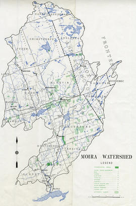
A map of the Moira Region Watershed. Polychrome colours symbolize the varieties of soils and land use surveys, see Legend. Not dated, circa 1950. Published by the Ontario Department of Planning and Development, Conservation Branch. Dimensions 58.5cmx 69cm.
"Cummins Rural Directory Map:" A map of South and Central Hastings, in 1923, featuring post offices, hamlets and lot owners. Map is surrounded by advertisements. Published by Cummins Map Co., Toronto. Dimensions 71cm x 50.5cm.
A map showing, primarily, the depth of the Moira River within Belleville, Ontario. Together with a written report, it proposed a channel to the New Ferry Slip. Major streets and some lots are also labelled. By John D. Evans, P.L.S. on April 28, 1881 or 1887. Scale: 66 feet : 1". Note the interesting colouring at dimmed edges.
3 parts of a map entitled "Source Areas [of] Reforestation Land and Existing Woodland" in the Moira Watershed. The varieties of land use include existing woodland, scrub areas, source areas, crown land, and timber licences. Published by the Ontario Department of Planning Development, Conservation Branch in 1950.
This file contains original copies of the Holbert Family Papers including: mortgages, deeds, insurance policies, correspondence, extension agreement, Sheriff's notice, indenture and abstract, dating from 1895 to 1925. Names include Phoebe Holbert, William Holbert, James Holbert, J. Wesley Holbert, Mouck and Geen.
File contains a publication from the Moira River Conservation Authority, titled “Progress and Achievements 1947-1962; a newspaper article from the Intelligencer dated January 20, 1965 with a photo of the County Warden; a publication from the Corporation of the Township of Sidney, Historic Highlights 1790-1967
Text of interviews with:
an individual who lived in Moira, Ontario and was 3 at the beginning of the Depression
an individual who lived in Huntingdon, Ontario and was 33 at the beginning of the Depression *a woman who lived on a farm and was 26 at the beginning of the Depression
A map for recreation purposes, showing existing and proposed facilities in the Moira River watershed area. Not dated, circa 1950. Dimensions 47.5cm x 35cm.
A map showing, primarily, zoning limits within the City of Belleville. The limits are coloured in crayon and can be referenced on the legend (left). The map was first created c. 1959 (as written in pencil). However, more recent revisions were made June 4, 1970. Scale: 1:12,000. Additional information about by-laws is available on the map's border.
Note the two names listed on the top left corner: K. Murray and D. Williams - possible authors or owners.
File contains the history of Moira Village and the Huntingdon Township, including first nations, french settlers, agriculture, lumbering, churches, population, politics, etc.
This file contains a publicity booklets titled "The Highlands of Hastings And The City of Belleville" published by the County and City of Belleville. Includes local attractions and advertisements for locale businesses.
Digital reproductions of photographs and research materials relating to the village of Moira, Ontario. Paper materials include an edition of the Ontario Intelligencer of 7 August 1934, reporting on a reunion at Moira and notes on the history of the Methodist/United church compiled by Owen Herity
This file contains pages from the publication Our Valley (Department of Planning and Development) volumes 1 thru 6 from July 1955 to the summer of 1960 pertaining to the Moira River.
"Moira Watershed Land Use Survey [for] Recommended Land Use." The varieties of land use include unrestricted, conservation farming, restricted use, permanent vegetation and woodland. Published by the Ontario Department of Planning Development, Conservation Branch in 1950.
Three volumes of accounts of the Moira Cheese Manufacturing Company and one volume (with missing boards) of shareholders' minutes and lists of shareholders.