An aerial photograph of Sidney Township, Concession 3 (Map # TD19689Z). The photo includes Concession 3 and part of Concession 4, Lots A, # 1 to 21, including proposed Hydro right of way and landowners names and instrument numbers. Photographed on September 10, 1973 and annotations made July 27, 1976. Scale 1 inch = 200 feet. For the Ontario Hydro Route and site Selection Division, Orthophoto R/W Selection Plan Lennox G. S. - Oshawa Area T. S. Aerial View. By J. E. Clements- photogrammetric production officer; D. Crozier- chief draftsman; J. Sedgwal- project engineer; C. E. Bishop- Sr R/W planning engineer.
Plan showing Sidney Township, part of Lot # 31, Concession 4, and the proposed right of way for Ontario Hydro Lines. (Map # TD30198D). For Ontario Hydro, Design and Construction Branch, Surveys and Mapping. Scale 1 inch = 60 feet. Drawn by R. Sweeney.
Plan showing Sidney Township, part of Lots # 25 to 29, concession 4 & part of Lot # 25, Concession 3, for proposed right of way for Ontario Hydro Lines (Map # TD30199Z). For Ontario Hydro, Design and Construction Branch, Surveys and Mapping. Scale 1 inch = 200 feet. Drawn by R. Sweeney.
An original map produced for the Hydro-Electric Power Commission of Ontario, concerning hydro power lines, stations and transformers. However, the map also features railways, roads and land boundaries.
This map is of the North Section - Frankford Rural Power District. The total area includes parts of Thurlow, Huntingdon, Sidney, Rawdon, Campbellford, Seymour, Brighton, and Percy Townships. Circa 1950. Donated by David Pershik.
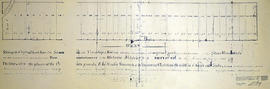
An original map produced for the Trenton Electric & Water Co. Limited, concerning proposed transmission lines within the Township of Sidney. However, the map also features railways, roads and land boundaries. Circa 1910. Scale: 50 chains = 1 inch. Map composed by Smith, Kerry and Chace Engineers located in Toronto, Winnipeg, Calgary and Vancouver.
A map of Sidney Township, the Plan of Lots on Gladstone Avenue/Trent Road, 1912. Published by Lucien & Allen C.E. on January 2nd, 1912. Created by A.W. Ponton, P.L.S. Scale: 100 feet : 1 inch.
A map of Hastings County outlining townships: Marmora, Lake, Madoc, Tudor, Grimsthorpe, Elzevir; Rawdon, Huntingdon, Hungerford, Sidney, Thurlow, Tyendinaga - as well as the northern townships. Inset is "the Village of Marmora." Surveyed by H. A. F. Macleod, C.E. and P.L.S. Published by W. A. Little Lith., Montreal in the 1864-1865 copy of the Hastings Directory . Scale: 1:190,000.
A map of Hastings County outlining townships from the Bay of Quinte in the south, to Wallaston, Limerick and Cashel in the north. Map is in four sections. Scale: 3 miles : 1 inch. Original map is dated 1894. Photocopy from the Archives of Ontario.
Proposal plan for Quinte area containing Sidney and Thurlow townships. Dated 31 Oct 1978. Scale: as shown. Published by the Quinte Planning Board. Composed by Laura.
A certified reproduction of the “Boundary Line Commissioners Survey of the Second Concession of Sidney, for the Victoria District..” The area contained includes; Sidney Township, Concession 2, Lot Block A and Lots # 1 to 38. Originally surveyed by John Emerson, P. L. S. and produced on September 4, 1840. This reproduction was made on June 2, 1972 and approved by the Deputy Registrar. Donated by Walter I. Watson, P. L. S.
A certified reproduction of the “Boundary Line Commissioners Survey of the Third Concession of Sidney, for the Victoria District.” The area contained includes; Sidney Township, Concession 3, Lots: Block A and Lots # 1 to 38. Originally surveyed by John Emerson, P. L. S. and produced circa 1841. This reproduction was made on June 5, 1972 and approved by the Deputy Registrar. Donated by Walter I. Watson, P. L. S.
A certified reproduction of the "Registrar's compiled plan, part of Lot # 26, in Broken Front Concession Township of Sidney.” The area includes; Lots west ½ and east ½ of Lot 26, Broken Front, being the north of side of Hwy 2. Registered March 9, 1967.
A certified reproduction of the "Registrar's compiled plan, being a graphic index of part of Lot # 28, Concession 1, Township of Sidney now City of Belleville.” The area includes; 14 Lots in Concession 1, west of Sidney Street and south of Moira Street. Surveyed by S. C. Geneja CST, Registry Office of Hastings and signed May 10, 1968.
A certified reproduction of the "Registrar's Compiled Plan, being a graphic index of part of Lot # 37, Concession 1, Township of Sidney... now City of Belleville.” The area includes; Lots # 1 to 15 Westerly from Sidney Street to Palmer Road and Northerly from Bridge St. West to Moira Street West.. Surveyed by S. C. Geneja CST, Registry Office of Hastings and signed May 28, 1968.
A certified reproduction of the "Registrar's Compiled Plan- being a graphic index of Lots # 6, 27, 28 and part of Lot # 21, Plan 1631, Township of Sidney.” The area includes; Lots # 1 to 48 Northerly from Hwy 2 to Canadian Pacific Railway and Easterly of Montrose Drive and County Club Drive. Surveyed by Walter I. Watson, O. L. S. and signed January 29, 1970.
A certified reproduction of the "Subdivision of Block A, Reg. Plan No. 1904, Belleville, owner Maurice H. Rollins.” The area includes; Lots # 1 to 14, Blocks A and B and Conger Place North of College Street West ( the third street west of Sidney Street). Surveyed by Walter I. Watson, O. L. S. and signed May 10, 1972.
A "Map of the Counties of Hastings and Prince Edward." In 1898, the lots, concessions, churches, schools and mines are shown of the townships in Hastings and Prince Edward. Scale: 1.5 miles to an inch. Published by the Canadian Map Publishing Company in Hamilton, Ontario, for the Belleville Sun. Revised by Henry Carre, C.E. Inset is the map of North Hastings, scale 400 chains to an inch.