Mostrando 208 resultados

Descripción archivística
Transportation and utilities
Imprimir vista previa Hierarchy Ver :

75 resultados con objetos digitales Muestra los resultados con objetos digitales

Aerial Photograph of Bowmanville

  • CA ON00156 M/M470-2781 - 2794/2787
  • Unidad documental simple
  • 1972
  • Parte deMap collection

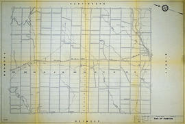
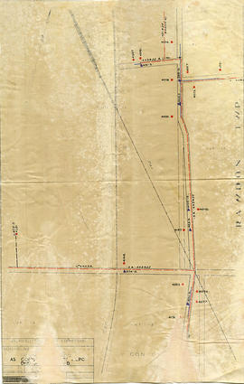
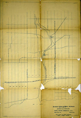
Bowmanville, Map # 2054 showing areas of; Bowmanville and Darlington Township, Concession 1 to 10, Lots # 1 to 29, Showing Ontario Hydro Line, gas and oil pipelines and proposed Darlington Generating Station site. From Ontario Hydro. Dated 1972. Scale: 1 inch = 2000 feet.

Aerial Photograph of Haldimand, Percy & Cramahe Townships

  • CA ON00156 M/M470-2781 - 2794/2790
  • Unidad documental simple
  • c. 1975
  • Parte deMap collection

An aerial photograph of Haldimand, Percy & Cramahe Townships, Map # 2056. The total area covered includes, Lots # 15 to 35, on Concession 4 to 10 in Cramahe Township, Lots # 3 to 16, on Concession 1 to 6, in Percy Township and Lots # 1 to 35, on Concession 1 to 10, in Haldimand Township, Northumberland County. An Ontario Hydro-Aerial Map, showing Hydro line and Trans Canada Pipe Lines. Circa 1975.

Hydro-Electric Power Commission of Ontario, Rawdon Section

  • CA ON00156 M/M430-2995 - 2996, 3018 - 3021, 3031/2995
  • Unidad documental simple
  • 16 Dec 1964
  • Parte deMap collection

A reproduction of an original map produced for the Hydro-Electric Power Commission of Ontario, concerning the boundaries of their eastern region in the Township of Rawdon. However, the map also features railways, roads and land boundaries. Dated December 16, 1964. Scale: 2 inches = 1 mile.

Donated by David Pershick.

Hydro-Electric Power Commission of Ontario, Napanee Section

  • CA ON00156 M/M430-2995 - 2996, 3018 - 3021, 3031/2996
  • Unidad documental simple
  • 2 Mar 1931
  • Parte deMap collection

A reproduction of an original map produced for the Hydro-Electric Power Commission of Ontario, concerning the boundaries of the Napanee Rural Power District, center section. However, the map also features railways, roads and land boundaries. Dated March 2, 1931. Scale: 2 inches = 1 mile.

The map includes the townships of Tyendinaga, Richmond and Camden (East).

Donated by David Pershick.

Hydro-Electric Power Commission of Ontario, Bonarlaw Section

  • CA ON00156 M/M430-2995 - 2996, 3018 - 3021, 3031/3031
  • Unidad documental simple
  • 24 Feb 1943
  • Parte deMap collection

An original map produced for the Hydro-Electric Power Commission of Ontario, concerning hydro power lines, stations and transformers in Bonarlaw, within the Township of Rawdon. However, the map also features railways, roads and land boundaries. Dated February 24, 1943.

This map includes parts of Concession 11 Lot # 13, Concession 12 Lot # 12 and Lot # 14.

Donated by David Pershick.

Trenton Electric & Water Co. Limited in Thurlow and Sidney Townships

  • CA ON00156 M/M430-2998 - 3001/M430-2999
  • Unidad documental simple
  • 31 Mar 1910
  • Parte deMap collection

An original map produced for the Trenton Electric & Water Co. Limited, concerning proposed transmission lines within the Townships of Thurlow and Sidney. However, the map also features railways, roads, mills and land boundaries. Dated March 31, 1910. Scale: 1/4 mile = 1 inch. Map composed by Smith, Kerry and Chace Engineers located in Toronto, Winnipeg, Calgary and Vancouver.

The map includes the first 4 concessions, Lots 33-38 in Sidney Township and Lots 1-13 in Thurlow Township.

Donated by David Pershick.

Sin título

The Political World & The Physical World

  • CA ON00156 M/M400-3036, 3038 - 3041, 3044/M400-3039
  • Unidad documental simple
  • Nov 1975
  • Parte deMap collection

A map showing "The Political World & The Physical World" by the National Geographic Society's Cartography Section. Dated November 1975.

Sin título

A Map of the Atlantic Gateways

  • CA ON00156 M/M400-3036, 3038 - 3041, 3044/M400-3041
  • Unidad documental simple
  • Mar 1983
  • Parte deMap collection

A map showing the gateways of the Atlantic Ocean in North America, by the National Geographic Society's Cartography Section. Scale: 1 centimeter = 13.2 kilometers or 1 inch= 20.8 miles. Dated March 1983.

Sin título

Map of Central Ontario Railways in 1847-1889

  • CA ON00156 M/M400-1009
  • Unidad documental simple
  • 1847-1889
  • Parte deMap collection

A map detailing the railways during 1847-1889 in Central Ontario. The legend assigns a number to the name of each railway. Composed and published by William Michaud of Shannonville, Ontario.

Sin título

New Railway and Commerical Map of Ontario

  • CA ON00156 M/M400-1016
  • Unidad documental simple
  • 1887
  • Parte deMap collection

"New Railway and Commercial Map of Ontario:" a map showing the upper right corner of Ontario, 1887. It features information and reference to railways at the time. Published and donated by S.R.G. Penson.
Received from the Archives of Canada's map collection - 27 Jul. 1966.

Sin título

Townships of Hastings County with advertisements

  • CA ON00156 M/M420-1104
  • Unidad documental simple
  • 1932
  • Parte deMap collection

A map of Hastings County, in 1932, showing lakes, rivers, cities, towns and townships. A list of businesses within the county are on the right. Drawn exclusively for and published by Croydon Publishing Company.

Sin título

Road Maps of Ontario

  • CA ON00156 M/M425-1028-1031, 1038 & M400-3042, 3043, 3047
  • Serie
  • 1961-2009
  • Parte deMap collection

Various road maps of Ontario published by the Canadian Government.

Foot Bridge across Moira River Blueprint

  • CA ON00156 M/M450-2823
  • Unidad documental simple
  • 21 Apr 1936
  • Parte deMap collection

A blueprint planning the suspension footbridge across the Moira River in Belleville, Ontario. Approved by Charles Mott - April 21, 1936. Submitted by Walter H. Patterson of the Patterson Construction Company.

Sin título

COR Station at Bannockburn Plans

  • CA ON00156 M/M450-1492
  • Unidad documental simple
  • 19 Jul 1902
  • Parte deMap collection

A blueprint planning the COR station at Bannockburn, Hastings County, Ontario. Plan features floor, platform plans, elevation and sections. Drawn by John Dunlop Evans, Chief Surveyor/Engineer - July 19, 1902.

Sin título

COR Station at Bloomfield Plans

  • CA ON00156 M/M450-1493
  • Unidad documental simple
  • 24 Jul 1900
  • Parte deMap collection

A blueprint planning the COR passenger station at Bloomfield, Hastings County, Ontario. Plan features floor, platform plans, elevation and sections. Drawn by John Dunlop Evans, Chief Surveyor/Engineer - July 24, 1909.

Sin título

Grand Trunk Station Marysville Plans

  • CA ON00156 M/M450-1507
  • Unidad documental simple
  • 15 Jun 1920
  • Parte deMap collection

A blueprint planning the Grand Trunk Railway station at Marysville, Hastings County, Ontario. Plan features floors, elevation and blocks. Drawn by Belleville Assistant Engineer - June 15, 1920.

COR Station at St. Ola Plans

  • CA ON00156 M/M450-1509
  • Unidad documental simple
  • 1911
  • Parte deMap collection

A blueprint planning the COR station at St. Ola, Hastings County, Ontario. Plan features floor, elevation and sections.

Plans for COR Station at Hillier

  • CA ON00156 M/M450-1516
  • Unidad documental simple
  • 18 Feb 1911
  • Parte deMap collection

A blueprint of the proposed new COR station at Hillier, Prince Edward County, Ontario. Drawn by John Dunlop Evans, Chief Engineer. Published by the Office of Master of Bridges and Buildings G.T.R. on February 18, 1911.

Sin título

Plans for COR Station at Picton

  • CA ON00156 M/M450-1517
  • Unidad documental simple
  • December 1901
  • Parte deMap collection

A blueprint of the proposed new COR station at Picton, Prince Edward County, Ontario. Drawn by John Dunlop Evans, Chief Engineer. Published by the Office of Master of Bridges and Buildings G.T.R. in December 1901.

Sin título

Resultados 121 a 140 de 208