Showing 1164 results

Archival description
Ontario Image
Print preview Hierarchy View:

1164 results with digital objects Show results with digital objects

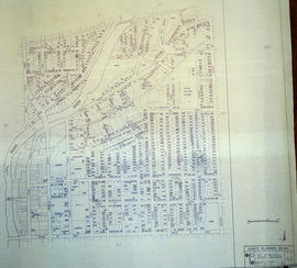
Carre's Plan of the city of Belleville 1892

A copy of a map planning streets and buildings in Belleville, Ontario, 1892. The total area extends from Belleville to Bay of Quinte to Bridge Street (sheet 2) and from Bridge Street to Concession Road Allowance - now College Street - (sheet 1). Surveyed by Henry Carre, Ontario Land Surveyor.

Scale: 10 chains to an inch.

Carre, Henry, O.L.S.

Cell Block and Basement Plans at Court House

A Floor Plan of the Main Cell Block and Basement at the County Court House on Pinnacle Street in Belleville, Ontario. The “Old Cells” are in the basement of the Court House. The Main Cell Block is connected to the Court House on the southeast. Composed by Charles A. Mott, City Engineer, and dated November 15, 1944.

Donated by Heritage Belleville in 2017.

Mott, Charles Allan

Central City of Belleville Map with Property Boundaries in 1976

A map of the City of Belleville, including property boundaries, waterways and roads. House numbers are also included. From Bridge Street East north to Station Street and from the Moira River east to Bleecker Avenue. Map composed by the Quinte Planning Board and dated February 23, 1976. Scale 1:2400.

Donated by the Heritage Belleville Committee in 2017.

Quinte Planning Board

Certification and Plan of Lot 32 in Belleville

A lot certification and map of Lot 32, at the intersection of Front and Bridge Streets, in the town of Belleville. Certified by P.L.S. David Williams and signed April 13, 1870.

Williams, David, P.L.S.

Champlain Map of 1616

The original map is a tracing of the printed map by Samuel de Champlain from "Les Voyages" in 1613. In the 1616 map, more additions were made to the north and south due to increased colonization. It shows Lake Ontario, here called Lac St. Louis today is known as Georgian Bay, Lake Huron and the Great Lakes.

The map was purchased by John Carter Brown Library, July 1953. The library had received it from Arthur Rau, an antique bookseller in Paris. Reproduced by the Meriden Gravure Society in 1956.

Champlain Society

Charter of the Argyll Chapter of the Imperial Order of the Daughters of Empire

  • CA ON00156 2019-050
  • Item
  • 10 November 1910

Founding charter of the Argyll Chapter (number 159) of the Imperial Order of the Daughters of Empire, granted by the National Chapter of Canada to founding members Mary G. Ponton, Zetta S. March, Bertha H. Vermilyea, Amy I. McFee, Helen G. Wallbridge, Edith R. Hyman, Helena G. Vermilyea, Amy R. Wallbridge, Mary Lee, Mary S. Orr, Flora M. Brown.

Imperial Order Daughters of the Empire

City of Belleville and Advertisements

A hand-drawn map of Belleville, Ontario in 1950. The map itself features street names and major water ways. Advertisements surround the map. Published by S. A. Renouf Advertising Co. and drawn by F. P. Lloyd. Scale 1:15,000.

S. A. Renouf Advertising Co.

City of Belleville map from Intelligencer

A map of the City of Belleville (with Trenton inset) featured in the September 20, 1961 issue of the Ontario Intelligencer. The map features houses that were open that week for viewing. At the bottom are sponsors of the map.

Intelligencer

City of Belleville Map with Property Boundaries in 1981

A map of the City of Belleville, including property boundaries, waterways and roads. From the Moira River in the east to the Bay of Quinte south and CNR & North Front Street in the north to Avondale Road in the west. Map composed by the Quinte Planning Board and dated October 1, 1981. Scale 1:4800.

Donated by the Heritage Belleville Committee in 2017.

Quinte Planning Board

City of Belleville on Acme advertisement

A map of the City of Belleville in 1950, on an advertisement for Acme Plumbing. The map itself features street names and major water ways. Street names are at the bottom of the map. Published by S. A. Renouf Advertising Co. and drawn by F. P. Lloyd. Scale 2" : 2,000 feet.

S. A. Renouf Advertising Co.

City of Belleville on hardware advertisement

A map of the City of Belleville in 1950, on an advertisement for Walker Hardware Company Limited. The map itself features street names and major water ways. Street names are at the bottom of the map. Published by S. A. Renouf Advertising Co. and drawn by F. P. Lloyd. Scale 2" : 2,000 feet.

S. A. Renouf Advertising Co.

CNR Crossing at Cannifton Road Blueprint

A blueprint planning the CNR crossing and gas mains at Cannifton Road in Belleville, Ontario. Drawn by Charles Mott - September 21, 1929. Scale: 1" : 4'0.
Features: 4/4/59 Canadian National Railways Agreement as to Laying Pipes Under Track.

Mott, Charles Allan

Collage of photographs of members of the Town Council of Deseronto, Ontario

  • CA ON00156 DA 2020.03
  • Item
  • 1898

Photographs of members of the council of the Town of Deseronto:
George E. Clement
James Sexsmith
William Irvine
James Whitton
J. M. Olliver
George Parnham
A. A. Richardson, Deputy Reeve
Frederick S. Rathbun, Treasurer
Edward Wilkes Rathbun, Mayor
Robert Irvine, Clerk
James Dryden, Reeve
J. McCollough, Assessor
George Gonyou, Chief of Police
G. E. Deroche, Solicitor
T. D. Galt
William Mellow
James Saunders

Town of Deseronto

Commercial Bank Subdivision of Lots 11-19 in Belleville

A certified reproduction of the "Commercial Bank Plan of subdivision of Lots # 11, 12, 13, 14, 15, 16, 17 and 19, of Belleville, being part of Lot # 2 Concession 1 Thurlow." Surveyed by John D. Evans, P.L.S., and dated April 18, 1873.

This copy was made in 1972 of plan #160, as registered in the Hastings Land Registry Office.

Donated by Walter I. Watson, O.L.S.

Evans, John Dunlop, P.L.S.

Copy of a Map of the Province of Ontario showing Railways

A reproduction of a "Map of the Province of Ontario Showing Railways now Running." A series of Toronto business advertisements line the bottom of the map. Originally published by the Canadian Almanac in 1884. Reproduced by COPP Clark Professional in January 1997 for the celebration of 150 continuous years of almanac and directory publishing.

Donated by the Belleville Public Library in 2014.

Copp Clark Limited

COR Station at Bannockburn Plans

A blueprint planning the COR station at Bannockburn, Hastings County, Ontario. Plan features floor, platform plans, elevation and sections. Drawn by John Dunlop Evans, Chief Surveyor/Engineer - July 19, 1902.

Evans, John Dunlop, P.L.S.

Results 61 to 80 of 1164