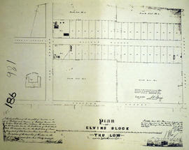
A certified reproduction of the "Plan of Elvins Block, being Park Lots # 2 on [the] east side of Park Street and west side of James Street, composed of part of Lots # 4 - 5 in 2nd Concession, Thurlow for Richard Elvins.” The total area surveyed includes both sides of College Avenue [Donald Street] between [North] Park Street and James Street [Prince of Wales Drive]. Albert College is pictured. Surveyed by John. J. Haslett, P. L. S. Plan registered on June 14, 1875.
This copy was made in 1972 of plan #186, as registered in the Hastings Land Registry Office.
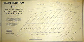
A certified reproduction of the “Willard Block.” A plan for part of Lot # 2 in the First Concession of Thurlow, [now Belleville] surveyed for Julia Willard. The area contained includes; 20 Lots bounded by Bridge St. West, Highland Ave., Ann Street and Willard St., being part of Lot # 2 Concession 1 Township of Thurlow. Originally surveyed by J. J. Haslett, P. L. S. and produced on August 23, 1848.
A certified reproduction of the “Coleman Block.” A plan for W. H. Coleman's Block between Bridge Street [West] and Moira Street, Belleville. The area contained includes; West of Coleman St., South of Moira St. West, Southerly to both sides of Jane St. and including both sides of Everitt and Cedar Streets, Henry St. and Catharine St.. Originally surveyed by J. J. Haslett, P. L. S. and produced 1852.
Plan of Vair's Block registered in the Hastings County Land Registry Office, showing Lots # 22 & 23 North side of Bridge Street & Lot # 15 West side of Town Line Street in Belleville, Ontario. The plan was drawn up John James Haslett, Provincial Land Surveyor, in November 1869.