A map showing, primarily, zoning limits within the City of Belleville. The limits are coloured in crayon and can be referenced on the legend (left). The map was first created c. 1959 (as written in pencil). However, more recent revisions were made June 4, 1970. Scale: 1:12,000. Additional information about by-laws is available on the map's border.
Note the two names listed on the top left corner: K. Murray and D. Williams - possible authors or owners.
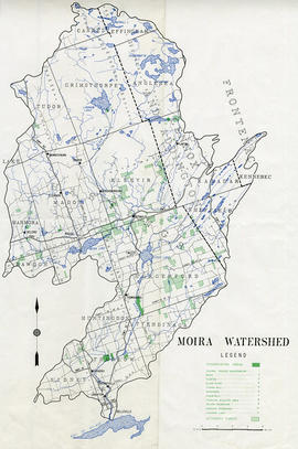
A map of the Moira Region Watershed. Polychrome colours symbolize the varieties of soils and land use surveys, see Legend. Not dated, circa 1950. Published by the Ontario Department of Planning and Development, Conservation Branch. Dimensions 58.5cmx 69cm.
3 parts of a map entitled "Source Areas [of] Reforestation Land and Existing Woodland" in the Moira Watershed. The varieties of land use include existing woodland, scrub areas, source areas, crown land, and timber licences. Published by the Ontario Department of Planning Development, Conservation Branch in 1950.
A map for recreation purposes, showing existing and proposed facilities in the Moira River watershed area. Not dated, circa 1950. Dimensions 47.5cm x 35cm.
"Moira Watershed Land Use Survey [for] Recommended Land Use." The varieties of land use include unrestricted, conservation farming, restricted use, permanent vegetation and woodland. Published by the Ontario Department of Planning Development, Conservation Branch in 1950.
A map of the Watersheds of the Moira and Napanee Rivers, 1950. From the Department of Planning and Development by A. H. Richardson, Chief Conservation Officer. Dimensions: 48cm x 35.5cm.
"Cummins Rural Directory Map:" A map of South and Central Hastings, in 1923, featuring post offices, hamlets and lot owners. Map is surrounded by advertisements. Published by Cummins Map Co., Toronto. Dimensions 71cm x 50.5cm.
A map showing, primarily, the depth of the Moira River within Belleville, Ontario. Together with a written report, it proposed a channel to the New Ferry Slip. Major streets and some lots are also labelled. By John D. Evans, P.L.S. on April 28, 1881 or 1887. Scale: 66 feet : 1". Note the interesting colouring at dimmed edges.