Showing 1230 results

Archival description
Item Land, settlement and immigration
Print preview Hierarchy View:

843 results with digital objects Show results with digital objects

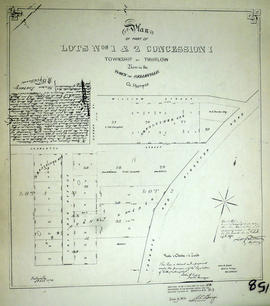
Plan of Ponton's Block in the Town of Belleville

A certified reproduction of the Plan of Ponton's Block, being Lots # 21 & 22 on the south side of Bridge Street West, Belleville, for William Hamilton Ponton, on the Commercial Bank Plan. Surveyed by John J. Haslett P.L.S. in 1853.

This copy was made in 1972 of plan #27, as registered in the Hastings Land Registry Office.

Donated by Walter I. Watson, O.L.S.

Haslett, John James, P.L.S. & D.P.S.

Plan of part of lots 1-2 in the Township of Thurlow

A certified reproduction of the "Plan of part of Lots # 1 & 2, Concession 1 Thurlow, Part of the Commercial Bank Plan. Resubdivided by owners Maria Murney and Nathaniel Baldwin Falkiner." Some of the lot owners are named along the south side of Charlotte Street: George Ritchie Lot # 28, Lt. Col. Campbell and Jacob Wilson Lot # 28. Surveyed by John D. Evans, P.L.S., and signed October 15, 1872.

This copy was made in 1972 of plan #158, as registered in the Hastings Land Registry Office.

Donated by Walter I. Watson, O.L.S.

Evans, John Dunlop, P.L.S.

Map of Mouth of Moira River

Reproduction of a map of a town site at the mouth of the Moira River [Belleville, Ontario]. Features lot owners and businesses already located in the area. Original by Samuel Wilmot, April 24, 1816. Scale: 1= 1,500.

Printed by the Hastings County Historical Society in 1969.

Wilmot, Samuel Street

The Vandervoorts of Sidney Township

This file contains a copy of a school project written by Scott Randolph from Foxboro Sr. Elementary School. It is titled "One Hundred and Eighty Years of Service" The Vandervoorts of Sidney Township and contains information about the genealogy of the Vandervoort Family commencing in 1784 with Peter Vandervoort.

Depth of the Moira River for Channel Plan

A map showing, primarily, the depth of the Moira River within Belleville, Ontario. Together with a written report, it proposed a channel to the New Ferry Slip. Major streets and some lots are also labelled. By John D. Evans, P.L.S. on April 28, 1881 or 1887. Scale: 66 feet : 1". Note the interesting colouring at dimmed edges.

Donated by the Col W. N. Ponton Estate.

Evans, John Dunlop, P.L.S.

Belleville and Bay of Quinte depth chart

Reproduction made in 1976 of an 1875 map of the Belleville Harbour in Bay of Quinte. The map features major streets, buildings and depth readings of travelled waters. Surveyed by F. M. Hamel, C.E. Drawn by J. M. Faga. Scale: 1:6000.

Hamel, F. M., C.E.

Shannonville - 1830

The file contains a newspaper article by A. Dempsey dated 30 April 1960, titled "Shannonville in 1830" giving a brief history of the settlement of the area and a clipping from Maclean's Reports about the Shannonville lease.

Intelligencer

Map of the Dominion of Canada and Newfoundland

A "Map of the Dominion of Canada and Newfoundland" published by the Copp Clark Co. Ltd. of Toronto in 1945.

The map served dual commercial and educational purposes. It advertises for a chocolate company with slogans and images: "Neilson's, The best chocolate bars in Canada [and] Neilson's Jersey milk chocolate - The best milk chocolate made." On the top right corner, an inscription writes that the map was for rural, underprivileged schools and was not to be removed from such locations.

Copp Clark Limited

Quaker Cemetery Huntingdon (Moira) Baker Family

This file contains 4 clippings pertaining to the Quaker Cemetery located in Moira.

  1. A newspaper article from the Ontario Intelligencer dated 2 October 1958 titled "Many Pioneers of District Buried in Moira Cemetery". The article references family names: Swetman, Mullett, Baker, Wood, Hudson, Howe, Denyke and Grass
  2. A handwritten genealogy of the Baker Family beginning with William and Ann Baker from Ireland
  3. An article titled "The Quaker Church" giving a brief history of the church and referencing family names: Mullett, Swetman, Merrill, Latta, Hockey, Wood, Haight, Ostrom, Baker, McTaggart, and Ketcheson
  4. A copy of a page taken from an unknown publication with family information for the Vantassel Family, the Baker Family and Later Families with names Diamond, Denike, Outwaters, Emerson, McGowan and Lafferty.

Plan of Diseronca (Deseronto)

1972 copy of an 1837 plan of 'Diseronca' (now Deseronto, Ontario), surveyed by G.J. Clapp on August 26th, 1837. The plan is Plan 43 of the plans registered in the Hastings County Registry.

The north-south streets shown on the right side of the map are, from right to left, First Street, Second Street, Third Street and Fourth Street. Near the end of Fourth Street a wharf is marked on the map. This is Culbertson's Wharf.

Clapp, Gilbert S. P.L.S.

Aerial Photograph of Hamilton and Hope Townships

  • CA ON00156 M/M470-2781 - 2794/2789
  • Item
  • 27 Aug 1973
  • Part of Map collection

Hamilton & Hope Townships, Map (order) 841-5711 showing areas of; Hamilton & Hope Townships-including Cobourg & Port Hope showing Hydro lines and gas & oil pipelines. Dated August 27, 1973. Scale: 1 inch = 2000 feet.

Crown sale grant of land in Marmora Township

  • 2022-039
  • Item
  • 1867

Province of Canada sale of Crown Lands (lot 15 in the fifth concession of Marmora Township) to John Fidlar, yeoman, of Marmora Township for $300.

Government of Canada

Results 1 to 20 of 1230