- CA ON00156 2010-41
- Item
- c.1980
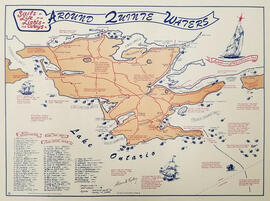
Map showing the location, names and dates of shipwrecks around the shoreline of Prince Edward County.
Ralley, Allan A.
4 results with digital objects Show results with digital objects
Map showing the location, names and dates of shipwrecks around the shoreline of Prince Edward County.
Ralley, Allan A.
CD-ROM of The Salmon River Watershed: Jewel of Eastern Ontario
Friends of the Salmon River

Drone photograph of wildfire smoke over Belleville, Ontario
Photograph taken by drone of wildfire smoke conditions in Belleville, Ontario.
Goulah, Andrew
Front page of Northern Telecom publication "The Switching Post"
Front cover of Northern Telecom publication The Switching Post for January/February/March 1981, with an aerial photograph of flooding on the west side of Belleville, west of Coleman Street and north of Dundas Street.
Nortel Networks

Hydrographic map of the Bay of Quinte from Picton to Presqu'ile Bay
A hydrographic map of the area surrounding the Bay of Quinte, Picton to Presqu'ile Bay in Ontario, Canada. With maps of Trenton Approaches, and Telegraph Narrows inset. Published by the Canadian Hydrographic Service, Marine Sciences Directorate, Department of the Environment, Ottawa. Sheet number 2069.
Scale: 1:60,588
Canadian Hydrographic Service
Booklet produced by the Friends of McGeachie about the McGeachie Conservation Area on Steenburg Lake in Limerick Township, Hastings County, Ontario.
Friends of McGeachie

Moira River Conservation Authority Progress and Achievements, 1947-1962
Printed report on the activities of the Moira River Conservation Authority in Ontario, including maps and photographs.
Moira River Conservation Authority
Photocopy of Community Improvement Plan, Town of Deseronto
Community Improvement Plan revised on 12 December 1988 (project number 24-7109-07).
Totten Sims Hubicki Associates Limited