
The Belleville Directory for 1877
- CA ON00156 CH/13/1/4
- Unidad documental simple
- 1877
Parte deCounty of Hastings records
Digital copy of Hoogs & Milette's 1877 directory of Belleville, Napanee, Trenton, and Brighton.
22 resultados con objetos digitales Muestra los resultados con objetos digitales
The Belleville Directory for 1877
Parte deCounty of Hastings records
Digital copy of Hoogs & Milette's 1877 directory of Belleville, Napanee, Trenton, and Brighton.
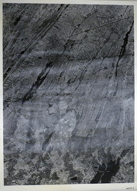
Sheffield Township Map # 445771E
Parte deMap collection
A reproduction of an air survey photograph produced by the Ontario Ministry of Natural Resources. Map #445771E of Sheffield Township in Lennox and Addington County, Ontario. Circa 1950.
The photograph shows Sheffield Township, Concession 3 to 9, Beaver Lake and north to Kaladar Township, Concession VIII to XI, Lingham Lakes in Grimthorpe Township in Hastings County.
Donated by Walter I. Watson, P.L.S.
Sin título
Ontario Hydro Aerial Photograph Plan of Lots 8-12 in Richmond Township
Parte deMap collection
Plan showing Richmond Township, Lennox & Addington County, Lots # 8 -12, Concession 3 & Lots # 1 to 12, Concession 4 (Map # TD19683Z). For Ontario Hydro, Route and Site Selection Division Orthophoto R/W Selection Plan. Scale: 1 inch = 20 feet. By J. E. Clements-photogrammetric production officer.
Sin título
Topographical map of Denbigh - east half
Parte deMap collection
A topographical map of Denbigh - Canada sheet #31 F/3, east half. Published by the Army Survey Establishment, Department of National Defence in 1951. Scale 1:50,000.
Sin título
Topographical map of Denbigh - Canada sheet
Parte deMap collection
A topographical map of Denbigh - Canada sheet #31 F/3. Published by the Army Survey Establishment, Department of National Defence in 1948. Scale 1:50,000.
Sin título
Topographical map of Kaladar - east half
Parte deMap collection
A topographical map of Kaladar - Canada sheet #31 C/11, east half. Published by the Army Survey Establishment, Department of National Defence in 1950. Scale 1:50,000.
Sin título
The file contains an original Rations Book issued to Will Wartman, Bath, Ontario, during WWII.
This file contains 6 copies of a Programme for the Third Annual Meeting of the Belleville District Library Association dated Thursday, the 7th of March, 1912.

Parte deCounty of Hastings records
Digital copy of 1893 Union Publishing Company's directory of the Counties of Durham, Hastings, Lennox, Addington, Northumberland, Prince Edward

Richmond Township Map # 443771E
Parte deMap collection
A reproduction of an air survey photograph produced by the Ontario Ministry of Natural Resources. Map #443771E of Richmond Township in Lennox and Addington County, Ontario. Circa 1950.
The photograph shows Richmond Township and the east part of Tyendinaga Township.
Donated by Walter I. Watson, P.L.S.
Sin título
Hydro-Electric Power Commission of Ontario, Napanee Section
Parte deMap collection
An original map produced for the Hydro-Electric Power Commission of Ontario, concerning hydro power lines, stations and transformers. However, the map also features railways, roads and land boundaries.
This map is of the South Section - Napanee Rural Power District. The total area includes parts of Ernestown, Frederickburgh South, Frederickburgh, Richmond, Tyendinaga, and Adolphustown Townships. Dated January 23, 1942. Scale: 2 inches = 1 mile.
Donated by David Pershik.
Map of Napanee Administrative District 1980
Parte deMap collection
A map of the Napanee Administrative District including Northumberland, Hasting County, Prince Edward County, Lennox Addington counties. Published by the Ministry of Natural Resources in 1980.
Donated by the Belleville Public Library in 2014.
Sin título

Map Hastings, Prince Edward, Northumberland and Peterborough Counties
Parte deMap collection
A map of Hastings, Prince Edward, Northumberland and Peterborough counties in 1916 from the Department of Interior Canada. Published by J.E. Chalifour, Chief Geographer. Scale: 3" to 95 miles. Dimensions 63.5cm x 96.5cm.
The legend includes additional information about counties, towns, villages, boundaries, railways, canals, lots, concessions, portages, rapids and First Nations Territories.
Sin título
Map of Lennox and Addington, Frontenac and Prince Edward Counties.
Parte deMap collection
A map of Lennox and Addington, Frontenac and Prince Edward Counties as of April 1st, 1974. Published by Engineering Plans Office, Cartography section. Produced by the Ministry of Transportation and Communications. Map features information regarding roads, settlements, boundaries, parks and transportation. Scale: 1:250,000. Dimensions: 71cm x 56cm.
Sin título

Map of Hastings County and Townships
Parte deMap collection
A map outlining Hastings County and the townships within. Neighboring counties are also present: Peterborough, Northumberland, Haliburton, Renfrew and Lennox and Addington. The Quinte region, including the cities of Belleville and Trenton are outlined at the bottom of the map.
Map of Land Ownership and Fish Species in Bancroft-Mazinaw
Parte deMap collection
A map describing areas of land ownership and fish species in Bancroft/Mazinaw. The map covers the following townships:
Hastings County: Lake, Tudor & Grimsthorpe
Lennox and Addington County: Ashby, Denbigh, Effingham, Abinger & Anglesea
Frontenac County: Barrie, Clarendon, Miller, North Canonto, South Canonto, & Palmerston
Scale 1cm:1km. Published by the Ontario Ministry of Natural Resources in 1993.
Sin título
Topographical map of Bath - Canada sheet
Parte deMap collection
A topographical map of Bath - Canada sheet #31 C/2. Published by the Army Survey Establishment, Department of National Defence in 1948. Scale 1 inch to 1 mile = 1/63, 360.
Sin título
Topographical map of Mazinaw - east half
Parte deMap collection
A topographical map of Mazinaw Lake - Canada sheet #31 C/14, east half. Published by the Army Survey Establishment, Department of National Defence in 1956. Scale 1:50,000.
Sin título
Wellington Marbelite Brick Company
The file contains a certificate 10 shares of common stock in the Wellington Marbelite Brick Company, dated 23 May 1930.
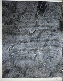
Sheffield Township Map # 444771E
Parte deMap collection
A reproduction of an air survey photograph produced by the Ontario Ministry of Natural Resources. Map #444771E of Sheffield Township in Lennox and Addington County, Ontario. Circa 1950.
The photograph shows the southwest part of Sheffield Township, Concession 1 to 6, Hwy 49, northwest corner of Camden East, northeast corner of Richmond Township and southeast corner of Hungerford with Village of Marlbank and Lime Lake.
Donated by Walter I. Watson, P.L.S.
Sin título