A topographical map of Bancroft - Canada sheet #31 F/4, east half. Published by the Army Survey Establishment, Department of National Defence in 1950. Scale 1:50,000.
A topographical map of Bancroft - Canada sheet #31 F/4, west half. Published by the Army Survey Establishment, Department of National Defence in 1950. Scale 1:50,000.
A topographical map of Bancroft - Canada sheet #31 F/4, west half. Published by the Army Survey Establishment, Department of National Defence in 1956. Scale 1:50,000.
A topographical map of Bancroft - Canada sheet #31 F/4, east half. Published by the Army Survey Establishment, Department of National Defence in 1956. Scale 1:50,000.
A topographical map of Bannockburn - Canada sheet #31 C/12. Published by the Army Survey Establishment, Department of National Defence in 1950. Scale one inch to one mile - 1/63,360.
A topographical map of Barry's Bay - Canada sheet #31 F/5. Published by the Army Survey Establishment, Department of National Defence in 1948. Scale 1 inch to 1 mile = 1/63, 360.
A topographical map of Bath - Canada sheet #31 C/2. Published by the Army Survey Establishment, Department of National Defence in 1948. Scale 1 inch to 1 mile = 1/63, 360.
A topographical map of Belleville - Canada sheet #31 C/3, west half. Published by the Army Survey Establishment, Department of National Defence in 1956. Scale 1:50,000.
A topographical map of Belleville - Canada sheet #31 C/3, east half. Published by the Army Survey Establishment, Department of National Defence in 1956. Scale 1:50,000.
A topographical map of Brockville - Canada sheet #31 B/12. Published by the Army Survey Establishment, Department of National Defence in 1951. Scale 1:50,000.
A topographical map of Campbellford - Canada sheet #31 C/5. Published by the Army Survey Establishment, Department of National Defence in 1956. Scale 1:50,000.
A topographical map of Campbellford - Canada sheet #31 C/5, east half. Published by the Army Survey Establishment, Department of National Defence in 1950. Scale 1:50,000.
A topographical map of Campbellford - Canada sheet #31 C/5, west half. Published by the Army Survey Establishment, Department of National Defence in 1950. Scale 1:50,000.
A topographical map of Clyde - Canada sheet #31 F/2, west half. Published by the Army Survey Establishment, Department of National Defence in 1951. Scale 1:50,000.
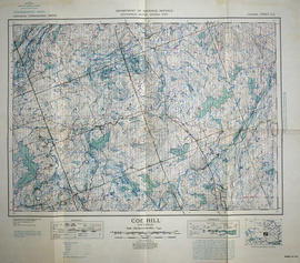
A topographical map of Coe Hill- Canada sheet #31 C/13. Published by the Army Survey Establishment, Department of National Defence in 1949. Scale one inch to one mile = 1/63,360.
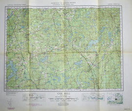
A topographical map of Coe Hill- Canada sheet #31 C/13. Published by the Army Survey Establishment, Department of National Defence in 1950. Scale one inch to one mile = 1/63,360.
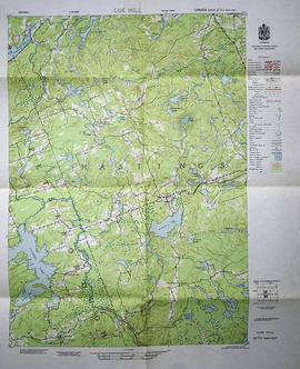
A topographical map of Coe Hill- Canada sheet #31 C/13, west half. Published by the Army Survey Establishment, Department of National Defence in 1956. Scale 1:50,000.
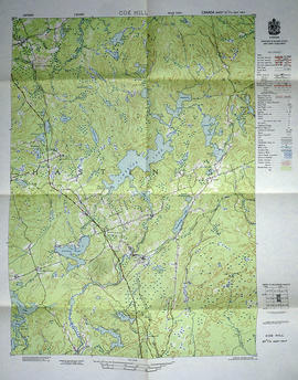
A topographical map of Coe Hill- Canada sheet #31 C/13, east half. Published by the Army Survey Establishment, Department of National Defence in 1956. Scale 1:50,000.
A topographical map of Denbigh - Canada sheet #31 F/3, east half. Published by the Army Survey Establishment, Department of National Defence in 1951. Scale 1:50,000.
A topographical map of Denbigh - Canada sheet #31 F/3, west half. Published by the Army Survey Establishment, Department of National Defence in 1951. Scale 1:50,000.