
Canadian Soldier's Handbook of General Information
- CA ON00156 2021-094/1
- 1943
Parte deInformation for Canadian servicemen in the Second World War
Scanned copy of a Ministry of National Defence publication for Canadian soldiers.
Sin título
33 resultados con objetos digitales Muestra los resultados con objetos digitales
Canadian Soldier's Handbook of General Information
Parte deInformation for Canadian servicemen in the Second World War
Scanned copy of a Ministry of National Defence publication for Canadian soldiers.
Sin título

Topographical map of Bancroft - east half
Parte deMap collection
A topographical map of Bancroft - Canada sheet #31 F/4, east half. Published by the Army Survey Establishment, Department of National Defence in 1950. Scale 1:50,000.
Donated by Gerry Boyce.
Sin título

Topographical map of Bancroft - west half
Parte deMap collection
A topographical map of Bancroft - Canada sheet #31 F/4, west half. Published by the Army Survey Establishment, Department of National Defence in 1950. Scale 1:50,000.
Donated by Gerry Boyce.
Sin título

Topographical map of Bancroft - west half
Parte deMap collection
A topographical map of Bancroft - Canada sheet #31 F/4, west half. Published by the Army Survey Establishment, Department of National Defence in 1956. Scale 1:50,000.
Donated by Gerry Boyce.
Sin título

Topographical map of Bancroft - east half
Parte deMap collection
A topographical map of Bancroft - Canada sheet #31 F/4, east half. Published by the Army Survey Establishment, Department of National Defence in 1956. Scale 1:50,000.
Donated by Gerry Boyce.
Sin título

Topographical map of Bannockburn - Canada sheet
Parte deMap collection
A topographical map of Bannockburn - Canada sheet #31 C/12. Published by the Army Survey Establishment, Department of National Defence in 1950. Scale one inch to one mile - 1/63,360.
Donated by Vera Crabbe in 2008.
Sin título
Topographical map of Barry's Bay - Canada sheet
Parte deMap collection
A topographical map of Barry's Bay - Canada sheet #31 F/5. Published by the Army Survey Establishment, Department of National Defence in 1948. Scale 1 inch to 1 mile = 1/63, 360.
Sin título
Topographical map of Bath - Canada sheet
Parte deMap collection
A topographical map of Bath - Canada sheet #31 C/2. Published by the Army Survey Establishment, Department of National Defence in 1948. Scale 1 inch to 1 mile = 1/63, 360.
Sin título

Topographical map of Belleville - west half
Parte deMap collection
A topographical map of Belleville - Canada sheet #31 C/3, west half. Published by the Army Survey Establishment, Department of National Defence in 1956. Scale 1:50,000.
Donated by Tom Ransom.
Sin título

Topographical map of Belleville - east half
Parte deMap collection
A topographical map of Belleville - Canada sheet #31 C/3, east half. Published by the Army Survey Establishment, Department of National Defence in 1956. Scale 1:50,000.
Donated by Gerry Boyce.
Sin título
Topographical map of Brockville - west half
Parte deMap collection
A topographical map of Brockville - Canada sheet #31 B/12. Published by the Army Survey Establishment, Department of National Defence in 1951. Scale 1:50,000.
Sin título
Topographical map of Campbellford - west half
Parte deMap collection
A topographical map of Campbellford - Canada sheet #31 C/5. Published by the Army Survey Establishment, Department of National Defence in 1956. Scale 1:50,000.
Sin título
Topographical map of Campbellford - east half
Parte deMap collection
A topographical map of Campbellford - Canada sheet #31 C/5, east half. Published by the Army Survey Establishment, Department of National Defence in 1950. Scale 1:50,000.
Sin título
Topographical map of Campbellford - west half
Parte deMap collection
A topographical map of Campbellford - Canada sheet #31 C/5, west half. Published by the Army Survey Establishment, Department of National Defence in 1950. Scale 1:50,000.
Sin título
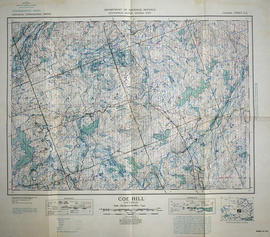
Topographical map of Coe Hill, Ontario
Parte deMap collection
A topographical map of Coe Hill- Canada sheet #31 C/13. Published by the Army Survey Establishment, Department of National Defence in 1949. Scale one inch to one mile = 1/63,360.
Donated by Gerry Boyce.
Sin título
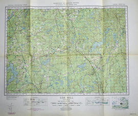
Topographical map of Coe Hill - Canada sheet
Parte deMap collection
A topographical map of Coe Hill- Canada sheet #31 C/13. Published by the Army Survey Establishment, Department of National Defence in 1950. Scale one inch to one mile = 1/63,360.
Donated by Gerry Boyce.
Sin título
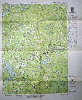
Topographical map of Coe Hill - west half
Parte deMap collection
A topographical map of Coe Hill- Canada sheet #31 C/13, west half. Published by the Army Survey Establishment, Department of National Defence in 1956. Scale 1:50,000.
Donated by Gerry Boyce.
Sin título
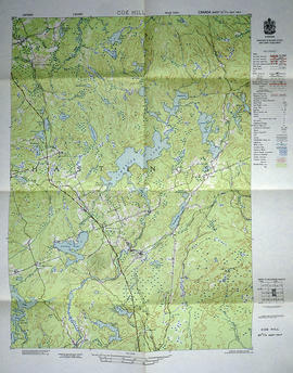
Topographical map of Coe Hill - east half
Parte deMap collection
A topographical map of Coe Hill- Canada sheet #31 C/13, east half. Published by the Army Survey Establishment, Department of National Defence in 1956. Scale 1:50,000.
Donated by Gerry Boyce.
Sin título
Topographical map of Denbigh - east half
Parte deMap collection
A topographical map of Denbigh - Canada sheet #31 F/3, east half. Published by the Army Survey Establishment, Department of National Defence in 1951. Scale 1:50,000.
Sin título
Topographical map of Denbigh - west half
Parte deMap collection
A topographical map of Denbigh - Canada sheet #31 F/3, west half. Published by the Army Survey Establishment, Department of National Defence in 1951. Scale 1:50,000.
Sin título