A map from the Eastern Canada series entitled "Topographic Map of Ontario - Belleville Sheet 31 C/3." The map includes Hastings County to Hillier in Prince Edward County. Published in 1938 by the Department of National Defence. Scale 1 inch to 1 mile.
A topographical map of Bancroft - Canada sheet #31 F/4, east half. Published by the Army Survey Establishment, Department of National Defence in 1950. Scale 1:50,000.
A topographical map of Bancroft - Canada sheet #31 F/4, east half. Published by the Army Survey Establishment, Department of National Defence in 1956. Scale 1:50,000.
A topographical map of Bancroft - Canada sheet #31 F/4, west half. Published by the Army Survey Establishment, Department of National Defence in 1956. Scale 1:50,000.
A topographical map of Bancroft - Canada sheet #31 F/4, west half. Published by the Army Survey Establishment, Department of National Defence in 1950. Scale 1:50,000.
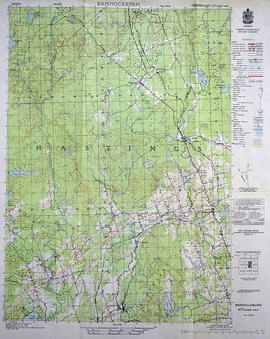
A topographical map of Bannockburn - Canada sheet #31 C/12. Published by the Army Survey Establishment, Department of National Defence in 1950. Scale one inch to one mile - 1/63,360.
A topographical map of Bannockburn - Canada sheet #31 C/12 (east half). Area includes Little Burnt Lake in the north, Crowe Lake and Deloro in the south. From Thompson Lake in the west to Bannockburn in the east. Map was published by the Department of National Defence in 1950. Scale 1:50,000.
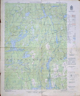
A topographical map of Bannockburn - Canada sheet #31 C/12, west half. Map was published by the Department of National Defence in 1950. Scale 1:50,000.
A topographical map of Belleville - Canada sheet #31 C/3 (west half). Area extends from North-Honeywell corner to South-Conscecon Lake and from East- Hungry Bay to West [racist slur redacted] Narrows. Map was published by the Department of National Defence in 1950. Scale 1:50,000.
A topographical map of Belleville - Canada sheet #31 C/3, east half. Published by the Army Survey Establishment, Department of National Defence in 1956. Scale 1:50,000.
A topographical map of Belleville - Canada sheet #31 C/3, west half. Published by the Army Survey Establishment, Department of National Defence in 1956. Scale 1:50,000.
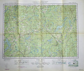
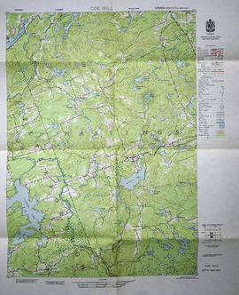
A topographical map of Coe Hill- Canada sheet #31 C/13. Published by the Army Survey Establishment, Department of National Defence in 1950. Scale one inch to one mile = 1/63,360.
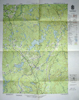
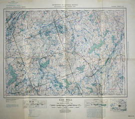
A topographical map of Coe Hill- Canada sheet #31 C/13, east half. Published by the Army Survey Establishment, Department of National Defence in 1956. Scale 1:50,000.
A topographical map of Coe Hill- Canada sheet #31 C/13, west half. Published by the Army Survey Establishment, Department of National Defence in 1956. Scale 1:50,000.
A topographical map of Coe Hill- Canada sheet #31 C/13. Published by the Army Survey Establishment, Department of National Defence in 1949. Scale one inch to one mile = 1/63,360.
A topographical map of Duck Island- Canada sheet #30 N/15. Published by the Army Survey Establishment, Department of National Defence in 1932. Scale one inch to one mile - 1/63, 360.
A topographical map of east Belleville - Canada sheet #31 C/3. Area extends from Tyendinaga Mohawk Territory to Lennox & Addington East to West and South to Picton Bay. Map was published by the Department of National Defence in November 1962. Scale 1:50,000.
A topographical map of Mazinaw Lake - Canada sheet #31 C/14. Published by the Army Survey Establishment, Department of National Defence in 1947. Scale 1 inch to 1 mile = 1/63.360.
A topographical map of Ontario - Campbellford sheet #31 C/5. Map was published by the Department of National Defence and reprinted in 1941. Scale 1:63,360.
A topographical map of the area between Belleville and Kingston. The total area extends from Prince Edward County to Buckshoot Lake North & South and from Havelock to Smith Falls East and West. Dated 1935. Published by the Department of National Defense.