"Sidney Township" maps apart of the zoning bylaws series. Dated 2 Feb 1978. Scale: 1:12,500. Published by the Quinte Planning Board. Composed by Laura.
A by-law map for the City of Belleville covering area from the Bay of Quinte to College Street & the Moira River to Sidney Street. Initially dated April 4, 1977 but revised later on October 2, 1996. Complied by the Quinte Planning Board. Scale 1;4800. Signed by Mayor J. Ben Corke and Clerk Earl M. Dafoe.
A by-law map for the City of Belleville covering area from the Bay of Quinte to College Street & Station Street, Herchimer Avenue to the Moira River. Initially dated April 4, 1977 but revised later on October 2, 1996. Complied by the Quinte Planning Board. Scale 1;4800. Signed by Mayor J. Ben Corke and Clerk Earl M. Dafoe.
A map of the City of Belleville, including property boundaries, waterways and roads. House numbers are also included. From Bridge Street East north to Station Street and from the Moira River east to Bleecker Avenue. Map composed by the Quinte Planning Board and dated February 23, 1976. Scale 1:2400.
Donated by the Heritage Belleville Committee in 2017.
A special policy area map for CFB Trenton. Dated 06 Jan 1979, revised 12 Feb 1979. Scale: 1 inch : 0.5 mile. Published by the Quinte Planning Board. Composed by Laura.
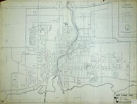
A map of the City of Belleville, including property boundaries, waterways and roads. From the Moira River in the east to the Bay of Quinte south and CNR & North Front Street in the north to Avondale Road in the west. Map composed by the Quinte Planning Board and dated October 1, 1981. Scale 1:4800.
Donated by the Heritage Belleville Committee in 2017.
Key to Zoning By-law Maps of the City of Belleville. Scale: 1:4800. Published by the Quinte Planning Board. 1) M440-1328. Dated 6 Nov 1976. Revised 2 Apr 1991. 2) M440-1329. Dated 6 Nov 1976. Revised 6 Jun 1991. 3) M440-1330. Dated 6 Nov 1976. Revised 19 Aug 1991. 4) M440-1331. Dated 6 Nov 1976. Revised 28 May 1991. 5) M440-1332. Dated 10 Oct 1990. 6) M440-1333. Dated 16 Dec 1985. Revised 21 Feb 1990. 7) M440-1334. Dated 19 Dec 1985. Revised
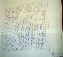
A map of the City of Belleville, including property boundaries, waterways and roads. House numbers are also included. From Bridge Street East north to Station Street and from the Bleecker Avenue east to Herchimer Avenue. Map composed by the Quinte Planning Board and dated February 23, 1976. Scale 1:2400.
Donated by the Heritage Belleville Committee in 2017.
A map featuring the streets in the City of Belleville, as well as important buildings (e.g. schools, churches etc.). Sponsored by and featuring advertisements from McDonald's, Four Seasons Sports, J. F. Nelles & Associates Inc., Complete Rent-alls, Lyons Motors, Shell and Midas.
Schedule plans A - F for the City of Belleville. Researched by the Quinte Planning Board. Published by Totten Sims Hubick; Associates Limited. All maps must be read in conjunction with the associative text provided. 1) M440-1344. Dated Jul 1988. Schedule A - Planning Districts and Planning Units. Scale 0-1000:4". 2) M440-1345. Dated Aug 1974. Revised Jan and Oct 1975. Schedule B - Land Use Plan. Scale 1" : 800ft. 3) M440-1346. Dated Aug 1974. Revised Jan and Oct 1975. Schedule C - Recreation Plan. Scale 1: 9600. 4) M440-1347. Dated Aug 1974. Revised Jan and Oct 1975. Schedule D - Residential Density Plan. Scale 1: 9600. 5) M440-1348. Dated Aug 1974. Revised Jan and Oct 1975 and Sep 1986. Schedule E - Transportation Plan. Scale 1: 9600. 6) M440-1349. Dated 1990. Schedule F - Municipal Services Plan. Scale 1: 9600.
A map featuring properties and boundaries in the City of Belleville. With area extending from Bay of Quinte to 401 and from N. Front Street to just past Haig Road. Published by the Quinte Planning Board. Scale 1" : 400'.
Proposal plan for Quinte area containing Sidney and Thurlow townships. Dated 31 Oct 1978. Scale: as shown. Published by the Quinte Planning Board. Composed by Laura.
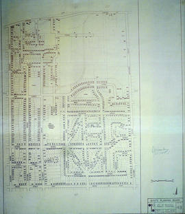
A map of the City of Belleville, including property boundaries, waterways and roads. House numbers are also included. From Bay of Quinte north to Bridge Street East and from the Moira River east to Foster Avenue. Map composed by the Quinte Planning Board and dated February 23, 1976. Scale 1:2400.
Donated by the Heritage Belleville Committee in 2017.
A map detailing local streets, schools and their respective names, in Belleville, Ontario. Composed by the Quinte Planning Board in October 1965. Revised November 1972.
A map detailing local streets, schools and their respective names, in Belleville, Ontario. Composed by the Quinte Planning Board in February 1974. Revised November 2, 1975.