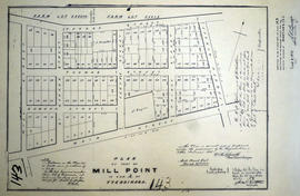
A certified reproduction of the Plan of part of Mill Point in parts of Lots # 38-39 in Concession A of Tyendinaga. Proprietors: H. B. Rathbun & E. W. Rathbun. Surveyed by William R. Aylsworth, P.L.S. and signed March 29, 1871.
This copy was made in 1972 of plan #143, as registered in the Hastings Land Registry Office.
1972 Copy of Plan 162 registered in the Hasting County Land Registry Office, drawn up in 1873. The plan shows the lots in the village of Mill Point (incorporated in 1871, later named Deseronto), Ontario.
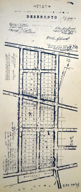
A certified reproduction of the "Plan showing of Blocks K and M of Deseronto, on west plot of Lot 3, Concession A, Township of Tyendinaga.” Blocks K and M are from Main Street north to the original Concession Road Allowance, west to Brant Street, and east to Mill Street. Plan signed by William R. Aylsworth, P.L.S. and dated March 26, 1885.
This copy was made in 1972 of plan #243, as registered in the Hastings Land Registry Office.
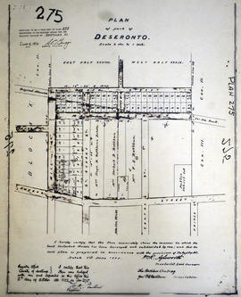
A certified reproduction of the "Plan of Part of Deseronto, Block J and Block H in part of Lot # 38 and Lot # 39 in Concession 2 and 3. Tyendinaga, for the Rathburn Company the proprietors.” Surveyed by William R. Aylsworth, P.L.S. and dated June 1, 1888.
This copy was made in 1972 of plan #275, as registered in the Hastings Land Registry Office.
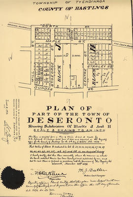
A certified reproduction of the "Plan of part of Deseronto, showing subdivision of Blocks J and H." Plan complied from W. R. Aylsworth P.L.S. in 1888 and resubdivided by M. J. Butler O.L.S. in November 14, 1898.
This copy was made in 1972 of plan #301, as registered in the Hastings Land Registry Office.